
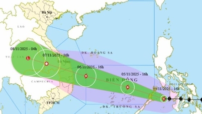
At 1:00 a.m. on November 4, the eye of the storm was over the central Philippines. The strongest wind near the eye of the storm was level 13 (134-149 km/h), gusting to level 16. The storm was still moving at a fast speed of about 25 km/h.
According to the Department of Hydrometeorology ( Ministry of Agriculture and Environment ), Kalmaegi storm is moving fast and very strong, so this agency is expected to issue an emergency storm warning as soon as the storm enters the East Sea (morning of November 5), which means that the storm is likely to affect Vietnam within the next 48 hours. Kalmaegi storm will also become storm number 13 in 2025.

Forecast of the path of typhoon Kalmaegi in the early morning bulletin on November 4. Photo: NCHMF.
From around the afternoon of November 4, the sea area east of the central East Sea will have winds gradually increasing to level 6-7, then increasing to level 8-10; near the storm center, winds will be level 11-13, gusting to level 15-16. Waves will be 5-7m high; the sea will be rough.
The storm is forecast to reach a level 13-14 intensity in the Truong Sa special zone and the Da Nang - Khanh Hoa sea area. During November 5-6, the central area of the East Sea (including the Truong Sa special zone), the sea area off the Da Nang - Khanh Hoa area is likely to be affected by strong winds of level 12-14, gusting over level 17. Waves are 8-10m high, the sea is very rough. All ships and structures operating in the above-mentioned dangerous area are strongly affected by storms, whirlwinds, strong winds and big waves.
From the night of November 6, the storm is likely to directly affect the area from Da Nang to Khanh Hoa . The strongest winds in coastal waters (including Ly Son special zone) are likely to reach level 12-13, gusting over level 15. Inland coastal areas are likely to reach level 10-12, gusting to level 14-15.
Widespread heavy rain is likely to begin from the night of November 6 to November 9 in the area from Quang Tri to Dak Lak. There is a risk of new flooding on rivers from Quang Tri to Khanh Hoa provinces.
The storm is still far away, so the current monitoring and forecast data still need to be monitored. The trajectory, intensity, direction of movement, rain center and rainfall are likely to fluctuate in the coming days. Therefore, the Department of Hydrometeorology recommends that ministries, branches and localities continue to closely monitor forecasts and warnings to proactively respond.
Source: https://nongnghiepmoitruong.vn/bao-kalmaegi-rat-manh-va-co-the-gay-dong-nguy-hiem-d782160.html
![[Photo] The road connecting Dong Nai with Ho Chi Minh City is still unfinished after 5 years of construction.](https://vphoto.vietnam.vn/thumb/1200x675/vietnam/resource/IMAGE/2025/11/04/1762241675985_ndo_br_dji-20251104104418-0635-d-resize-1295-jpg.webp)

![[Photo] Opening of the 14th Conference of the 13th Party Central Committee](https://vphoto.vietnam.vn/thumb/1200x675/vietnam/resource/IMAGE/2025/11/05/1762310995216_a5-bnd-5742-5255-jpg.webp)


![[Photo] Panorama of the Patriotic Emulation Congress of Nhan Dan Newspaper for the period 2025-2030](https://vphoto.vietnam.vn/thumb/1200x675/vietnam/resource/IMAGE/2025/11/04/1762252775462_ndo_br_dhthiduayeuncbaond-6125-jpg.webp)


![From working for hire to becoming a boss: [Lesson 5] Sending - learning - returning - creating](https://vphoto.vietnam.vn/thumb/402x226/vietnam/resource/IMAGE/2025/11/05/1762297489528_1546-anh-3-072934_320.jpeg)


Comment (0)