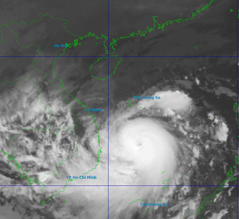
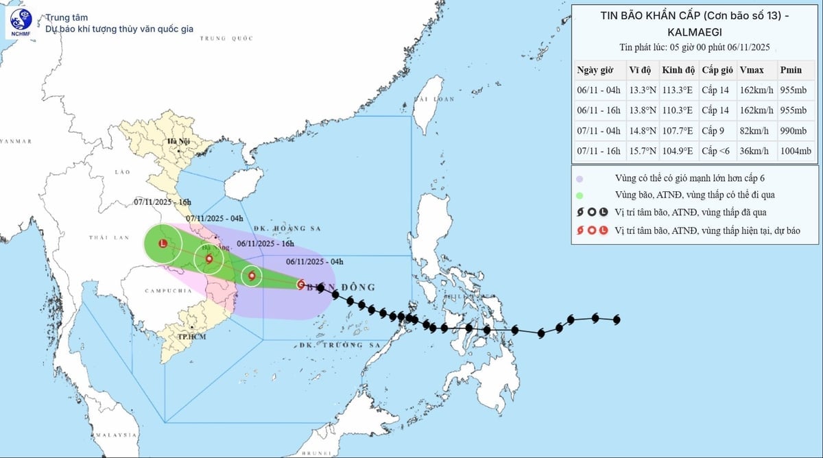
According to the National Center for Hydrometeorology, the storm maintained its intensity at level 14 (150-166 km/h), with gusts up to level 17, and moved faster than last night, at a speed of about 30 km/h.
Forecasts indicate that around 4 PM this afternoon, Typhoon No. 13 will be over the sea area from Quang Ngai to Dak Lak (including Ly Son Special Economic Zone) and will make landfall this evening. Due to the wide circulation of the typhoon, the meteorological and hydrological agency warns of the risk of thunderstorms, tornadoes, and strong gusts of wind both before and during the typhoon's landfall.

The position of Typhoon No. 13 at 6:00 AM on November 6th shows a wide area of storm circulation and the potential for thunderstorms and strong gusts of wind even before it approaches the coast. Photo: NCHMF .
From early morning, the sea area from southern Quang Tri to Khanh Hoa (including Ly Son special zone and Cu Lao Cham island) experienced increasingly strong winds, reaching levels 6-7, then increasing to levels 8-11, with waves 3-6 meters high. Near the center of the storm, winds reached levels 12-14, gusting to level 17, with waves 7-9 meters high; the sea was extremely rough.
Coastal areas from Hue City to Dak Lak are experiencing storm surges of 0.4-0.8m. The storm is very strong, so storm surges and large waves may occur as early as this afternoon, causing flooding in low-lying areas, overflowing dikes and coastal roads, coastal erosion, and slowing flood drainage in the region. All ships, boats, and aquaculture farms in the aforementioned vulnerable areas will be severely affected by thunderstorms, strong winds, large waves, and storm surges.
From this evening onwards, strong winds will gradually increase to level 6-7 in the inland area from southern Da Nang to Dak Lak, then to level 8-9. In the area near the storm's center, winds will reach level 10-12 (with the focus on the eastern part of Quang Ngai and Gia Lai provinces), with gusts up to level 14-15.
Areas from southern Quang Tri to northern Da Nang City and northern Khanh Hoa province will experience strong winds of force 6-7, gusting to force 8-9.
From the evening and night of November 6th, the western provinces from Quang Ngai to Gia Lai experienced increasingly strong winds, reaching levels 6-7, with areas near the storm's center experiencing winds of levels 8-9, gusting to level 11.

Forecast of the intensity and direction of Typhoon No. 13: The storm's wind intensity (level 8 or higher) will remain high until it moves further inland to the western border region. Photo: NCHMF .
Regarding heavy rainfall, on November 6-7, the area from Da Nang City to Dak Lak will experience very heavy rain with a common rainfall amount of 200-400mm/period, and in some localized areas exceeding 600mm/period.
The area from southern Quang Tri to Hue City, Khanh Hoa and Lam Dong will experience heavy rain with rainfall amounts generally ranging from 150-300mm per event, and locally very heavy rain exceeding 450mm per event.
From November 8th onwards, heavy rainfall in the aforementioned areas is expected to decrease.
On the 7th and 8th, the rain is expected to gradually shift northward, resulting in moderate to heavy rain in the area from northern Quang Tri to Thanh Hoa, with rainfall amounts generally ranging from 50-150mm per event, and locally exceeding 200mm per event.
Warning of risk of heavy rainfall exceeding 200mm within 3 hours.
According to the Department of Dike Management and Disaster Prevention, as of 4:30 PM on November 5th, they had notified, counted, and guided 61,475 vessels/291,384 workers, including 303 vessels/5,012 workers anchored in the Hoang Sa and Truong Sa special economic zones. These vessels have received the warning information and are moving to avoid the danger zone; no vessels are currently in the dangerous area.
Da Nang, Quang Ngai, Dak Lak, Khanh Hoa, and Gia Lai have banned sea travel, and Lam Dong province banned sea travel today, November 6th.
Source: https://nongnghiepmoitruong.vn/bao-so-13-con-cach-quy-nhon-360km-d782589.html


![[Photo] Close-up of an Australian warship visiting Tien Sa port, Da Nang](https://vphoto.vietnam.vn/thumb/1200x675/vietnam/resource/IMAGE/2026/03/28/1774675489416_tau-5-jpg.)


Comment (0)