
The storm is still at level 10-12 when it makes landfall.
According to Mr. Nguyen Van Huong, Head of Weather Forecasting Department (National Center for Hydro-Meteorological Forecasting), at 5:00 p.m. on November 5, storm No. 13 was active in the central East Sea, about 320km east of Song Tu Tay Island of Truong Sa special zone, and more than 900km from the mainland.
The storm is forecast to move relatively steadily until the morning of November 6 at a speed of about 20 - 25 km/h. The storm's intensity is currently at level 14, gusting to level 17 and may strengthen to early level 15. "The center assesses this as an especially dangerous storm and may maintain very strong winds when it makes landfall in our country from the evening to the night of November 6," Mr. Khiem emphasized.

Mr. Nguyen Van Huong informed about the forecast of storm No. 13. Photo: Quynh Huong.
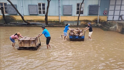
With such wind force, waves around the storm center can be 8-10m high, which can sink all types of boats, including large transport ships. Along the coastal area from southern Quang Tri to Dak Lak, people face strong winds of level 10-12 and waves of 4-6m high. Big waves can appear along the coast even before the storm arrives. In particular, the time when the storm arrives coincides with the period of high tide, with the risk of sea level rise of about 0.9-1.2m, threatening the sea dike system and causing flooding. With such combined impacts, boats, aquaculture cages along the coast of the above area are all at risk of being greatly affected by storm No. 13. In particular, although the storm has not yet made landfall, people need to be extremely vigilant against thunderstorms, whirlwinds, and strong gusts of wind before the storm.
On land, the storm circulation can cause very strong winds from Quang Tri to Khanh Hoa . The center of the storm is likely to be the provinces from Quang Ngai to Dak Lak. People need to be very careful that strong winds of level 10-12, gusting to level 15 and even stronger may appear. The strong wind area is likely to expand to the north, combined with cold air causing winds of level 8-9, gusting to level 11.
According to Mr. Mai Van Khiem, Director of the National Center for Hydro-Meteorological Forecasting, because storm No. 13 moves very quickly, strong winds will not only be found along the coast but also deep into the old Central Highlands provinces, between Gia Lai and Quang Ngai. Based on many years of experience in monitoring storm activity, the Center believes that this area may experience winds of level 9, even level 10 and gusts above level 12. This is extremely dangerous for residential areas, in addition to large constructions.

Mr. Mai Van Khiem, Director of the National Center for Hydro-Meteorological Forecasting, warned of the dangerous impacts of the storm. Photo: Thu Trang.
Regarding rain, the circulation of storm No. 13 is likely to cause a very heavy rain in the area for the provinces of the South Central and Central Central regions. The rain will not last long but will concentrate on the night of November 6 and November 7. The provinces of Gia Lai, Dak Lak, Quang Ngai, and Da Nang City will have heavy rain for about 36 hours, with expected rainfall of about 200-400mm, locally over 600mm. The area from southern Quang Tri to Hue City, Khanh Hoa and Lam Dong will have heavy rain with common rainfall of 150-300mm/period, locally over 450mm/period. Due to heavy rain for many days, such rainfall poses a very high risk of landslides and flash floods. Reservoirs, especially medium and small reservoirs in the South Central and Central Highlands regions, should also pay close attention and proactively prepare response plans.
Officers and observers are ready to forecast and warn.
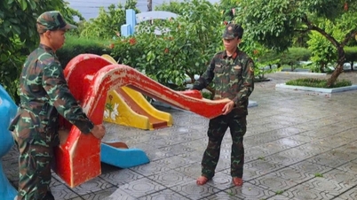
Over the past two days, the Central Hydrometeorological Station and provincial stations have been working with local Civil Defense Commands to review and finalize storm response plans. The Central Station has established shock troops at stations, ensuring that forces, vehicles, forecasting and communication equipment are ready for operation when the storm makes landfall. According to a quick report, provinces from Ha Tinh to Phu Yen (old) have issued sea bans, organized evacuation of people from dangerous areas and proactively prepared response plans when bad situations occur.

Deputy Minister of Agriculture and Environment Le Cong Thanh requested a plan to ensure safety for observers on duty. Photo: Quynh Huong.
Welcoming the preparedness of the hydrometeorological staff, Deputy Minister Le Cong Thanh emphasized the need to ensure maximum safety for observers on direct duty, especially at island stations and meteorological stations in high positions where the winds are strongest.
The storm is very strong and likely to make landfall at night, passing through areas that have suffered damage from heavy rain and floods before. The Deputy Minister requested units to focus on closely monitoring the storm's wind developments in mountainous areas, paying attention to warnings for both transport vessels in dangerous areas at sea and along the coast; risk of heavy rain, rising water in irrigation lakes and reservoirs in the Central Highlands.
In particular, in the context of a two-level government, the stations need to be the contact points with communes and wards, regularly update information to serve the command work of natural disaster prevention, and minimize damage caused by storm No. 13 in the coming time.
Putting storm prevention and control work in a "more urgent state"
Earlier on the morning of November 5, chairing a meeting to deploy response work to storm No. 13, Deputy Prime Minister Tran Hong Ha emphasized that it is necessary to proactively respond to storm Kalmaegi (storm No. 13) in a "more urgent and more dangerous" situation.
The Deputy Prime Minister requested the Ministry of Agriculture and Environment to forecast "with higher requirements" and provide "more dense" information for each stage. Forecasts should be compared with previous storms to help localities and people visualize.
Regarding reservoirs, the Deputy Prime Minister requested the Ministry of Agriculture and Rural Development, the Ministry of Industry and Trade and the Chairmen of the Provincial People's Committees to "take responsibility from now on", assess the safety of reservoirs, operate, and reduce to a safe water level to have flood-cutting capacity on November 6-8, when there is a possibility of heavy rain of 200 to over 300 mm.
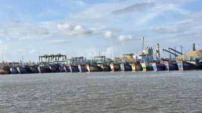
For sea and aquaculture areas, the Deputy Prime Minister requested a 100% ban on ships and rafts going out to sea. People are absolutely not present at sea after 5 p.m. on November 6. Police and border guards ensure safety and control people's property. The evacuation of people from dangerous areas must be completed before 7 p.m. on November 6 in coastal areas subject to high tides and high, isolated, and landslide-prone mountainous areas. Localities must work immediately with Military Region 4 and Military Region 5 to determine forces, numbers, and means, "not waiting until the situation is isolated before sending in troops".
The Ministry of Agriculture and Environment is in charge of consulting with the Ministry of National Defense on arranging a location for the National Civil Defense Steering Committee to work and directly direct localities in the storm's eye area.
On November 5, the Department of Management and Construction of Irrigation Works (Ministry of Agriculture and Environment) also sent a telegram to provinces and cities from Thanh Hoa to Lam Dong; investors of new construction projects, repair and upgrade of irrigation works in provinces and cities from Thanh Hoa to Lam Dong about lowering the water level of reservoirs if downstream conditions allow to ensure the safety of irrigation works, to prevent flooding and inundation due to heavy rains affected by storm No. 13.
Source: https://nongnghiepmoitruong.vn/bao-so-13-tang-cuong-do-cac-dia-phuong-can-het-suc-de-phong-d782521.html


![[Photo] Opening of the 14th Conference of the 13th Party Central Committee](https://vphoto.vietnam.vn/thumb/1200x675/vietnam/resource/IMAGE/2025/11/05/1762310995216_a5-bnd-5742-5255-jpg.webp)


![[Photo] Panorama of the Patriotic Emulation Congress of Nhan Dan Newspaper for the period 2025-2030](https://vphoto.vietnam.vn/thumb/1200x675/vietnam/resource/IMAGE/2025/11/04/1762252775462_ndo_br_dhthiduayeuncbaond-6125-jpg.webp)


Comment (0)