
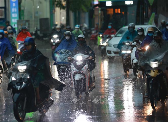
It is forecasted that in the evening and night of October 30, cold air will begin to affect the Northeast, then spread to the North Central, Northwest and Central Central regions.
From October 30 to November 1, it is forecasted that due to the combination of East wind disturbances, the Northeast region will have scattered rain. From the night of November 1, the North and North Central regions will have cold nights and mornings, and cold in mountainous areas. The lowest temperature is commonly 19-22 degrees Celsius, and in mountainous areas below 17 degrees Celsius.
Hanoi area from October 30 to November 1 will have rain, from November 1 it will be cold at night and in the morning, temperature 20-22 degrees Celsius.
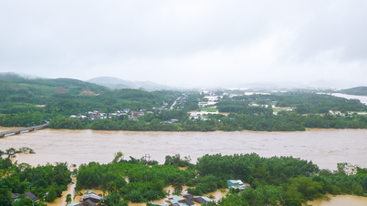
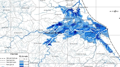
Exceptionally large floods on many rivers
Currently, floods on Huong River and Bo River (Hue City) are rising again, floods on Vu Gia-Thu Bon River ( Da Nang City), Tra Khuc River and Dakbla River (Quang Ngai) are rising.
Water levels at 2:00 p.m. on October 29 on the rivers were as follows: On the Bo River at Phu Oc station, it was 4.72m, 0.22m above alert level 3; on the Huong River at Kim Long station, it was 4.33m, 0.83m above alert level 3; on the Vu Gia River at Ai Nghia station, it was 10.15m, 1.15m above alert level 3; on the Thu Bon River at Cau Lau station, it was 5.18m, 1.18m above alert level 3; on the Tra Khuc River at Tra Khuc station, it was 7.77m, 1.27m above alert level 3; on the Dakbla River at Kon Tum station, it was 517.82m, below alert level 1.
In the next 12 hours, floods on Bo River, Huong River, Vu Gia-Thu Bon River, Tra Khuc River will continue to rise and exceed alert level 3 by 0.4-1.8m; the flood peak of Thu Bon River at Cau Lau station is likely to be equivalent to the historical flood peak in 1964 (5.48m); Dakbla River will rise to alert level 2.
In the next 12-24 hours, flood levels on Bo River and Huong River will gradually decrease and from alert level 3 to above alert level 3 by 0.8m; Tra Khuc River will gradually decrease and be below alert level 3; Vu Gia - Thu Bon River will remain at a high level and above alert level 3 by 1.0-1.2m; Dakbla River will be below alert level 1.
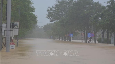
The situation of deep and widespread flooding from Hue city to Quang Ngai province will continue for the next few days; there is a high risk of flash floods on rivers and streams and landslides on slopes in provinces/cities from Hue to Quang Ngai. Flood risk warning level: Level 3.
Heavy rain from Nghe An to Quang Ngai
Today (October 29), in Hue city, Da Nang and the East of Quang Ngai province, there is heavy to very heavy rain. The rainfall from 7am to 3pm on October 29, locally, in some places, was over 150mm such as: Bach Ma Peak station (Hue) 406.4mm, Ba Na station (Da Nang) 232.8mm, Tra Nham station (Quang Ngai) 170mm...
From the evening of October 29 to the early morning of October 30, Quang Ngai province had moderate to heavy rain with rainfall of 30-60mm, locally very heavy rain over 100mm (from October 30, the rain decreased).
From the evening of October 29 to October 30, in the area from South Quang Tri to Da Nang city, there will be heavy to very heavy rain with common rainfall of 100-250mm, locally over 500mm (from the night of October 30, heavy rain is likely to gradually decrease).
From the evening of October 29 to October 31, the area from Southern Nghe An to Northern Quang Tri will have moderate to heavy rain with common rainfall of 70-150mm, locally very heavy rain over 300mm.
Warning of risk of heavy rain (over 150mm/3h).
In addition, in the evening and night of October 29, in the Central Highlands, the South and the East of the provinces from Gia Lai to Lam Dong, there will be rain, moderate rain and thunderstorms with rainfall of 15-40mm, locally heavy to very heavy rain over 100mm. During thunderstorms, there is a possibility of tornadoes, lightning, hail and strong gusts of wind. Warning of the risk of heavy rain (over 80mm/3 hours).
From the night of October 31 to November 1, in the area from Nghe An to Northern Quang Tri, there will be moderate to heavy rain with common rainfall of 50-100mm, locally very heavy rain over 200mm.
Warning level of natural disaster risk due to heavy rain, tornado, lightning, hail: level 1, level 2 in Hue city and Da Nang area.
Strong winds at sea
During the night of October 29 and 30, the sea area north of the North East Sea will have strong northeast to east winds at level 6, gusting to level 7-8; rough seas, waves 3-5m high, wave direction from northeast to east.
In addition, on the night of October 29 and 30, the southern Gulf of Tonkin, the sea area from southern Quang Tri to Ca Mau, from Ca Mau to An Giang, the Gulf of Thailand, the northern and central East Sea areas (including Hoang Sa special zone), as well as the southern East Sea area (including Truong Sa special zone) will have scattered showers and thunderstorms.
During thunderstorms there is a possibility of tornadoes, strong gusts of wind level 6-7 and waves over 2 meters high.
On the night of October 30 and 31, the northeastern sea area of the North East Sea will have strong northeast winds of level 6, gusting to level 7-8; rough seas, waves 2-4m high.
The Gulf of Tonkin has strong northeast winds of level 5, sometimes level 6, gusting to level 7-8; rough seas, waves 1.5-2.5m high.
All vessels operating in the above areas are at high risk of being affected by strong winds and large waves. Marine disaster risk level: Level 2.
Specific weather in each region on the night of October 29 and October 30
In the Northwest region, there will be rain in some places at night and intermittent sunshine during the day. The lowest temperature will be from 19-22 degrees Celsius, in some places below 18 degrees Celsius; the highest temperature will be from 26-29 degrees Celsius.
In the Northeast region, there will be rain in some places at night; during the day there will be scattered rain and showers. Northeast wind level 2-3. Lowest temperature from 21-24 degrees Celsius, in mountainous areas below 20 degrees Celsius; highest from 25-28 degrees Celsius.
The area from Thanh Hoa to Hue has moderate to heavy rain, locally very heavy rain and thunderstorms; the area from South Quang Tri to Da Nang has heavy to very heavy rain. The wind from the North to Northwest is level 2-3, cold at night. During thunderstorms, there is a possibility of tornadoes, lightning and strong gusts of wind. The lowest temperature is from 21-24 degrees Celsius, the highest is from 25-28 degrees Celsius.
In the South Central Coast region, the North has moderate rain, heavy rain, locally very heavy rain and thunderstorms; the South has rain, moderate rain, scattered thunderstorms, locally heavy to very heavy rain. In the North, the wind is from the Northeast to the East, in the South, the wind is from the Southwest at level 2-3. During thunderstorms, there is a possibility of tornadoes, lightning and strong gusts of wind. The lowest temperature is from 22-25 degrees Celsius, the highest is from 28-31 degrees Celsius.
The Central Highlands region has rain, moderate rain and scattered thunderstorms, locally heavy to very heavy rain, mainly concentrated in the afternoon and at night. Light wind. During thunderstorms, there is a possibility of tornadoes, lightning, hail and strong gusts of wind. The lowest temperature is from 19-22 degrees Celsius, in some places below 19 degrees Celsius; the highest is from 25-28 degrees Celsius, in some places above 28 degrees Celsius.
The Southern region has rain, moderate rain and scattered thunderstorms, locally heavy to very heavy rain, concentrated in the afternoon and at night. West to Southwest wind level 2-3. During thunderstorms, there is a possibility of tornadoes, lightning, hail and strong gusts of wind. The lowest temperature is from 23-26 degrees Celsius, the highest is from 29-32 degrees Celsius.
Hanoi has rain in some places at night; scattered rain and showers during the day. Northeast wind level 2-3. Lowest temperature from 22-24 degrees Celsius, highest from 26-28 degrees Celsius.
Ho Chi Minh City has rain, moderate rain and scattered thunderstorms, locally heavy to very heavy rain, mainly in the afternoon and at night. West to Southwest wind level 2-3. During thunderstorms, there is a possibility of tornadoes, lightning, hail and strong gusts of wind. Lowest temperature from 24-26 degrees Celsius, highest from 30-32 degrees Celsius.
Source: https://baotintuc.vn/van-de-quan-tam/chieu-toi-va-dem-3010-khong-khi-lanh-anh-huong-den-dong-bac-bo-20251029172629686.htm
![[Photo] Fall Fair 2025 - An attractive experience](https://vphoto.vietnam.vn/thumb/1200x675/vietnam/resource/IMAGE/2025/10/30/1761791564603_1761738410688-jpg.webp)


![[Photo] Prime Minister Pham Minh Chinh chaired a meeting to evaluate the operation of the two-level local government model.](https://vphoto.vietnam.vn/thumb/1200x675/vietnam/resource/IMAGE/2025/10/29/1761751710674_dsc-7999-jpg.webp)
![[Photo] New-era Party members in the "Green Industrial Park"](https://vphoto.vietnam.vn/thumb/1200x675/vietnam/resource/IMAGE/2025/10/30/1761789456888_1-dsc-5556-jpg.webp)


Comment (0)