
According to the forecast of the Central Hydrometeorological Station, from November 3, the cold air mass will affect Da Nang city. Due to the influence of the cold air mass strengthening combined with disturbances in the high-altitude East wind zone, from the night of November 2 to the afternoon of November 4, in the communes and wards in the northern part of the city, there will be moderate rain, heavy rain to very heavy rain with common rainfall of 150-300mm, some places over 400mm. The communes and wards in the southern part will have heavy rain, very heavy rain and thunderstorms with common rainfall of 200-350mm, some places over 450mm. During thunderstorms, be on guard against lightning, hail and strong gusts of wind, heavy rain with an intensity of over 120mm/3 hours.
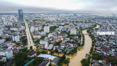
It is forecasted that in the next 24 hours, the flood on Vu Gia - Thu Bon River will rise to level 2-3; the Han River at Cam Le will fluctuate at level 1-2. Warning: From today (November 2) to November 4, the flood on Tam Ky River is likely to rise again. The flood peak on Tam Ky River will be at level 1 to above level 2.
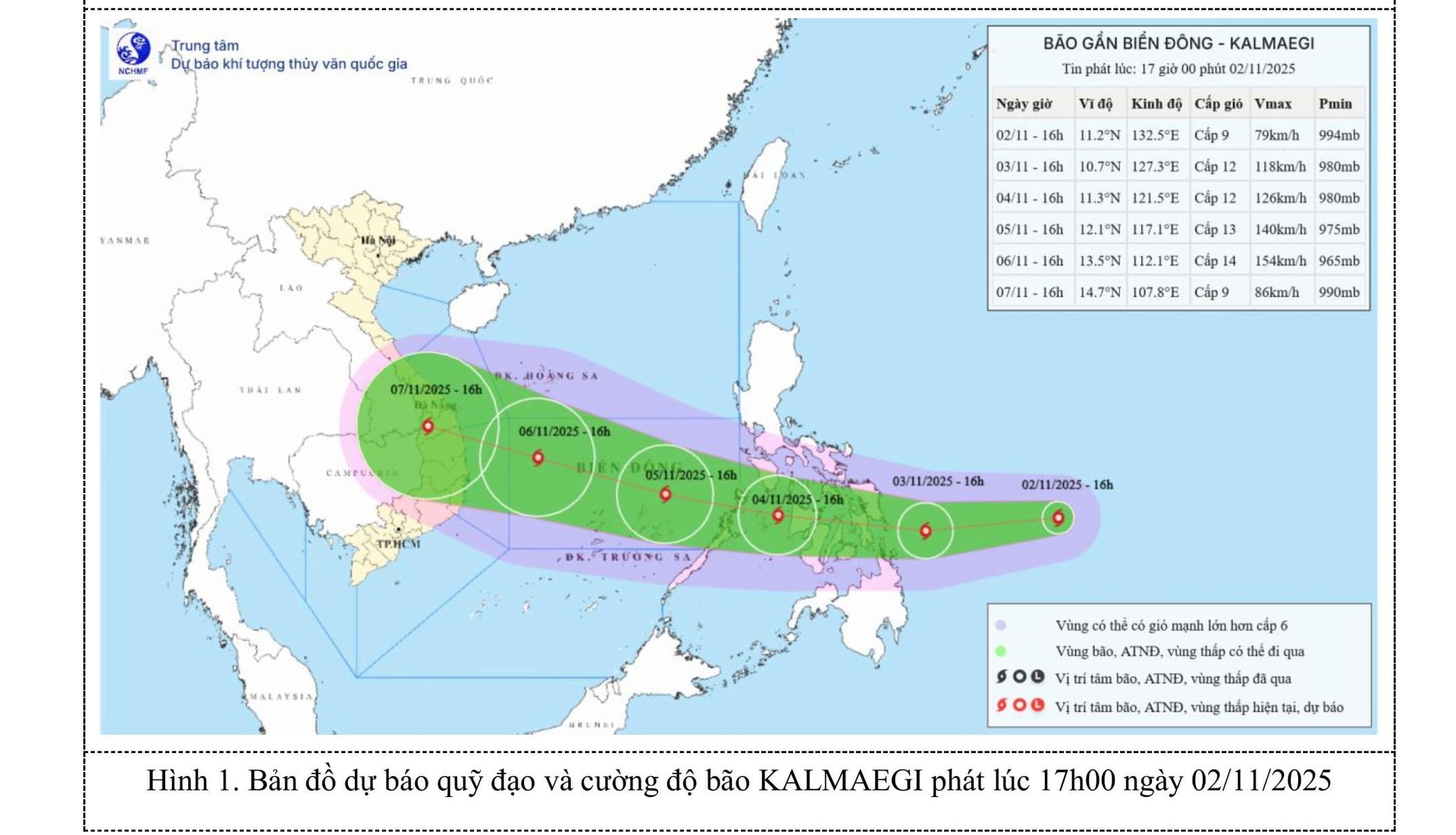
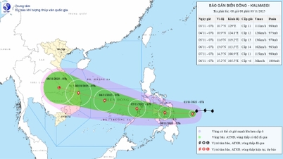
In addition, there is an active storm in the sea east of the central Philippines, internationally named Kalmaegi. It is forecasted that by November 5, storm Kalmaegi will enter the East Sea and become storm number 13. Due to the storm's influence, from the afternoon and night of November 4, the sea east of the central East Sea will have winds gradually increasing to level 6-7, then increasing to level 8-9; near the center of the storm, winds will be level 10-12, gusting to level 14-15, with waves 5-7m high. The sea will be very rough.
To proactively respond to natural disasters, the Da Nang City Civil Defense Command requested armed forces units, departments, branches, sectors, People's Committees of communes, wards, special zones and related units to continue to ensure the contents according to the direction of the Chairman of the City People's Committee on focusing on overcoming damage caused by heavy rain and floods and responding to weather trends from now until the end of 2025; proactively respond to cold air and warning of heavy rain in Da Nang City.
The Department of Education and Training, People's Committees of communes and wards, depending on the actual situation of the flood and the characteristics of each locality (especially paying attention to localities at risk of landslides), proactively decide to let students stay home from school. The City Military Command, the City Border Guard Command, the Department of Agriculture and Environment, the Da Nang Coastal Information Station, and People's Committees of coastal communes and wards continue to closely monitor the development of storm Kalmaegi and dangerous weather conditions at sea, promptly notify owners of vehicles and boats still operating at sea to proactively take precautions. The City Border Guard Command proactively checks, counts, and manages boats going out to sea according to regulations.
Source: https://hanoimoi.vn/da-nang-len-ke-hoach-ung-pho-bao-kalmaegi-721912.html

![[Photo] Prime Minister Pham Minh Chinh receives the Chairman of the Japan-Vietnam Friendship Association in the Kansai region](https://vphoto.vietnam.vn/thumb/1200x675/vietnam/resource/IMAGE/2025/11/03/1762176259003_ndo_br_dsc-9224-jpg.webp)

![[Photo] General Secretary To Lam receives Singaporean Ambassador Jaya Ratnam](https://vphoto.vietnam.vn/thumb/1200x675/vietnam/resource/IMAGE/2025/11/03/1762171461424_a1-bnd-5309-9100-jpg.webp)

![[Photo] Lam Dong: Close-up of illegal lake with broken wall](https://vphoto.vietnam.vn/thumb/1200x675/vietnam/resource/IMAGE/2025/11/03/1762166057849_a5018a8dcbd5478b1ec4-jpg.webp)


Comment (0)