
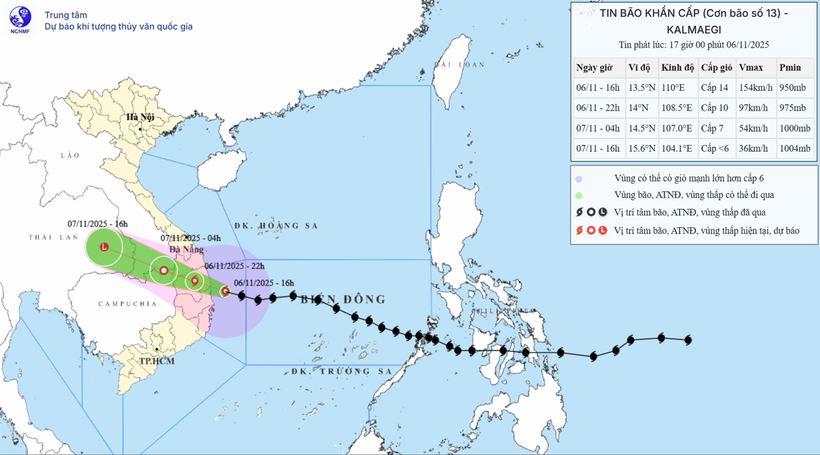
According to the National Center for Hydro-Meteorological Forecasting, on the night of November 6, storm No. 13 (Kalmaegi) will make landfall in the area from Quang Ngai to Dak Lak and gradually weaken.
Due to the influence of the storm, at Ly Son station (Quang Ngai), there were strong winds of level 8, gusts of level 10; Dung Quat (Quang Ngai) strong winds of level 8, gusts of level 9; Hoa Nhon Dong (Gia Lai) strong winds of level 6, gusts of level 9; Phu Cat (Gia Lai) strong winds of level 8, gusts of level 11; Hoi An ( Da Nang ) strong winds of level 8, gusts of level 10; in the area from Hue city to Khanh Hoa, there was heavy rain in some places over 100mm such as: An Xuan station (Dak Lak) 162mm, Bong Son (Gia Lai) 146mm, Sa Huynh (Quang Ngai) 119mm...
By 10 p.m. on November 6, the storm on land in the area from Quang Ngai to Dak Lak, the strongest wind is level 10, gusting to level 12, moving in the West Northwest direction at a speed of 30 km/h and gradually weakening. The affected area is the sea from Quang Ngai to Dak Lak (including Ly Son special zone); the mainland to the East of the area from Quang Ngai to Gia Lai , north of Dak Lak, natural disaster risk level 4.
West of the central East Sea area, the sea area from South Quang Tri to Da Nang city (including Cu Lao Cham island) and Khanh Hoa; mainland South Quang Tri to Da Nang city, South Dak Lak province and North Khanh Hoa province with level 3 natural disaster risk level.
Forecast by 4am on November 7, the storm in the Southern Laos area, with the strongest wind speed of 7, gusting to level 9, will move in the West Northwest direction at a speed of 30 km/h and gradually weaken into a tropical depression.
The affected area is the sea from South Quang Tri to Da Nang city (including Ly Son special zone, Cu Lao Cham island) and Khanh Hoa; mainland South Quang Tri to Da Nang city, South Dak Lak province and North Khanh Hoa province with level 3 natural disaster risk.
Then, at 4:00 p.m. on November 7, the tropical depression in the eastern region of Thailand moved west-northwest at a speed of 30 km/h, with winds below level 6, and weakened into a low pressure area.
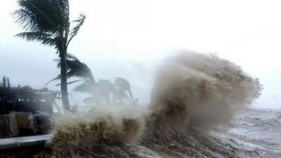
Due to the influence of the storm, the sea area west of the central East Sea has strong winds of level 8 - 10; near the eye of the storm, strong winds of level 11 - 12, gusts of level 14, waves 5 - 7m high, near the eye of the storm, 8 - 10m high; rough seas.
The sea area from South Da Nang to Dak Lak (including Ly Son special zone, Cu Lao Cham island) has strong winds of level 8 - 11, waves 4 - 7m high; the area near the storm center has strong winds of level 12 - 14, gusts of level 16, waves 8 - 10m high; the sea is very rough.
The sea area from South Quang Tri to North Da Nang and Khanh Hoa has strong winds of level 6-8, waves 3-5m high; rough seas.
The highest sea level in Thuan An is 1m, Son Tra is 1.2m, Hoi An is 1.3m, Dung Quat is 1.5m, Quy Nhon is 1.2m, Tuy Hoa is 1.1m.
Coastal areas from South Quang Tri to Dak Lak are warned to be on guard against sea level rise of 0.5 - 1m accompanied by large waves causing flooding in low-lying areas, waves overflowing dikes, coastal roads, coastal erosion, slowing down flood drainage in the area. All ships, boats, and aquaculture areas in the above-mentioned dangerous areas are strongly affected by storms, whirlwinds, strong winds, large waves, and rising sea levels.
From the south of Da Nang city to Dak Lak, strong winds of level 6-9, the area near the storm's eye will be strong at level 10-12 (focusing on the east of Quang Ngai-Gia Lai provinces, the north of Dak Lak), gusting at level 15; the area from the south of Quang Tri to the north of Da Nang city and the north of Khanh Hoa province will be strong at level 6-7, gusting at level 8-9. The strongest winds will be from the evening to the night of November 6.
In the West, from Quang Ngai to Gia Lai provinces, there are strong winds of level 6 - 7, near the storm's eye, there are strong winds of level 8 - 9, gusting to level 11.
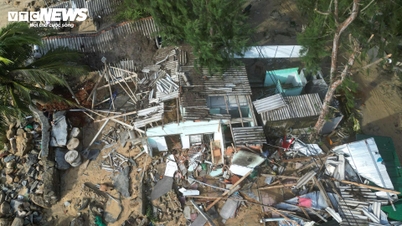
From the evening of November 6-7, the area from Da Nang city to Dak Lak will have very heavy rain with common rainfall of 150-300mm, locally over 500mm; the area from South Quang Tri to Hue city, Khanh Hoa and Lam Dong will have heavy rain with common rainfall of 100-250mm, locally over 400mm. From November 8, heavy rain in the above areas will tend to decrease.
From November 7-8, the area from northern Quang Tri to Thanh Hoa will have moderate to heavy rain with common rainfall of 50-150mm, locally very heavy rain over 200mm. Warning of risk of heavy rain over 200mm/3 hours.
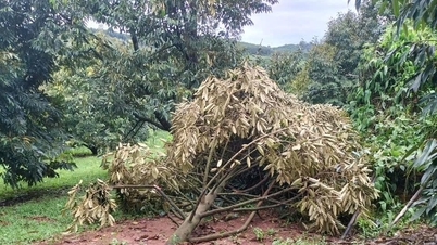
Due to the influence of the wide storm circulation, it is necessary to guard against the risk of thunderstorms, tornadoes and strong gusts of wind both before and during the storm's landfall.
Director of the National Center for Hydro-Meteorological Forecasting Mai Van Khiem said the path and impact of storm No. 13 is similar to storm No. 12 (Damrey) in 2017 and storm No. 9 (Molave) in 2020, but storm No. 13 will cause heavier rain in the area from Da Nang city to Dak Lak.
Storm No. 12 (Damrey) in 2017, when making landfall in the provinces of Phu Yen and Khanh Hoa, had a strong intensity of level 9, causing heavy rain in the Hue - Khanh Hoa area from 150 - 250mm, Gia Lai - Dak Lak about 80 - 150mm; some places had heavier rain such as: Nam Dong (Hue) 321mm; Tam Ky, Tien Phuoc (old Quang Nam) 280mm; Ba To (Quang Ngai) 338mm; Son Giang (Quang Ngai) 382mm; An Nhon (Gia Lai) 296mm, Quy Nhon (Gia Lai) 295mm; An Khe (Gia Lai) 266mm, Krong Pa (Gia Lai) 237mm...
Storm No. 9 (Molave) in 2020 when it made landfall in the Quang Ngai-Da Nang area had a strong intensity of level 11-12, gusting to level 14. The storm caused heavy rain from 150-400mm in many places from Nghe An to Dak Lak, some stations measured rainfall of over 550mm.
PVSource: https://baohaiphong.vn/dem-nay-bao-so-13-di-vao-dat-lien-tu-quang-ngai-den-dak-lak-va-suy-yeu-dan-525849.html


![[Photo] Da Nang: Hundreds of people join hands to clean up a vital tourist route after storm No. 13](https://vphoto.vietnam.vn/thumb/1200x675/vietnam/resource/IMAGE/2025/11/07/1762491638903_image-3-1353-jpg.webp)


Comment (0)