
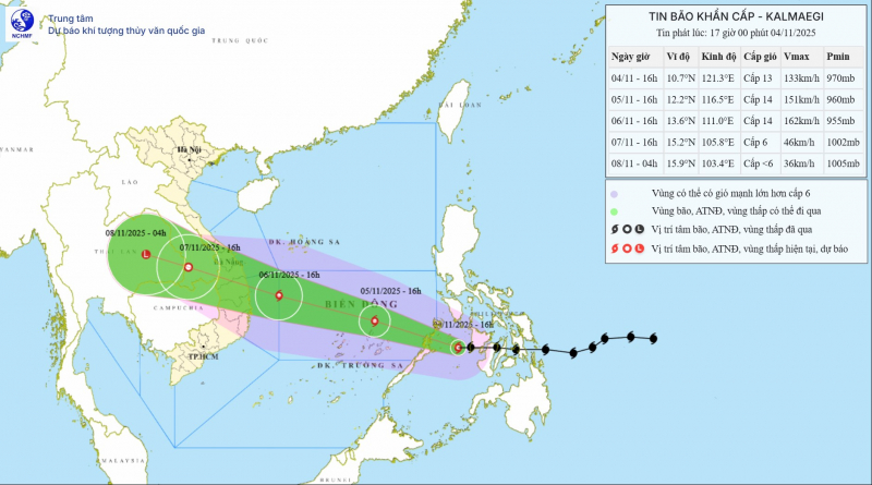
On the afternoon of November 4, Director of the National Center for Hydro-Meteorological Forecasting Mai Van Khiem said that at 4 p.m., storm Kalmaegi was in the sea west of the central Philippines with a level 13 intensity, gusting to level 16.
Mr. Khiem assessed that storm Kalmaegi has a relatively fast moving speed. Current forecasts show that the storm is very strong, when it approaches the mainland of our country, there are very few factors that can cause the storm to quickly weaken.
"Based on Decision 18/2021 of the Prime Minister regulating forecasting, warning, transmission of natural disasters and disaster risk levels, at 5:00 p.m. this afternoon, although the storm has not officially entered the East Sea, the National Hydrometeorological Agency has decided to issue an urgent storm bulletin to raise vigilance about the impact of this storm in the coming days," Mr. Khiem informed.
According to the current forecast of the National Center for Hydro-Meteorological Forecasting, early in the morning of November 5, storm Kalmaegi entered the East Sea and became storm number 13. After entering the East Sea, the storm moved very quickly, and its intensity is likely to continue to increase.
“Through discussions with international storm centers such as Japan, China... and through analysis of monitoring system data, we believe that storm No. 13 will reach its maximum intensity when it reaches Truong Sa special zone. Around November 6, the storm may reach level 14, gusting to level 16-17. Some models even calculate that the storm intensity in Truong Sa special zone may be above level 14,” said Mr. Khiem.
According to forecasts, around the afternoon of November 6, storm No. 13 will move into the central sea. From the night of November 6, the storm is likely to directly affect the area from Da Nang to Khanh Hoa, causing strong winds. Coastal areas may have strong storm winds of level 10-12, gusting to level 15, deep inland there is a possibility of strong storm winds of level 7-9, gusting to level 13-14.
Heavy rain will occur from the night of November 6 to November 9, with heavy rain concentrated in the provinces from Quang Tri to Dak Lak .
According to the assessment of meteorological experts, this is a very strong storm, with a wide storm circulation and strong winds directly affecting coastal provinces/cities from South Quang Tri to Dak Lak. The path and impact of storm No. 13 are similar to storm No. 12 (Damrey) in 2017 and storm No. 9 (Molave) in 2018.
Therefore, ministries, branches, localities and people need to continue monitoring because scenarios on storm intensity and direction, rain center and rainfall are likely to fluctuate in the coming days.
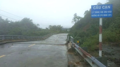
From the evening of November 5, coastal areas from Hue City to Dak Lak should be on guard against rising sea levels accompanied by large waves causing flooding in low-lying areas, waves overflowing dikes, coastal roads, coastal landslides, and slowing flood drainage in the area.
All ships, boats, and aquaculture areas in the above-mentioned dangerous areas are strongly affected by storms, whirlwinds, strong winds, big waves, and rising sea levels.
From the evening of November 6, on the mainland along the coast from South Quang Tri to Da Nang City, the East of Quang Ngai and Dak Lak provinces, the wind gradually increased to level 6-7, then increased to level 8-9, the area near the storm's eye was strong at level 10-12 (in the center is the East of Quang Ngai - Dak Lak provinces), gusting to level 14-15.
From the evening and night of November 6, the western part of Quang Ngai and Gia Lai provinces will gradually increase the wind to level 6-7, the area near the storm's eye will increase to level 8, gusting to level 10.
From November 6 to 7, the area from Da Nang City to Dak Lak will have very heavy rain with common rainfall of 200-400mm/period, locally over 600mm/period; the area from South Quang Tri to Hue City, Khanh Hoa and Lam Dong will have heavy rain, locally very heavy rain with common rainfall of 150-300mm/period, locally over 450mm/period. From November 8, heavy rain in the above areas is likely to decrease.
From November 7 to 8, the area from North Quang Tri to Thanh Hoa will have moderate rain, heavy rain, and locally very heavy rain with common rainfall of 50-150mm/period, locally over 200mm/period. Warning of risk of heavy rain (>200mm/3 hours)
Due to the influence of the wide storm circulation, it is necessary to guard against the risk of thunderstorms, tornadoes and strong gusts of wind both before and during the storm's landfall.
Source: https://cand.com.vn/Xa-hoi/du-bao-chua-vao-bien-dong-viet-nam-quyet-dinh-phat-tin-bao-khan-cap-i787015/
![[Photo] Opening of the 14th Conference of the 13th Party Central Committee](https://vphoto.vietnam.vn/thumb/1200x675/vietnam/resource/IMAGE/2025/11/05/1762310995216_a5-bnd-5742-5255-jpg.webp)


![[Photo] Panorama of the Patriotic Emulation Congress of Nhan Dan Newspaper for the period 2025-2030](https://vphoto.vietnam.vn/thumb/1200x675/vietnam/resource/IMAGE/2025/11/04/1762252775462_ndo_br_dhthiduayeuncbaond-6125-jpg.webp)


Comment (0)