
 |
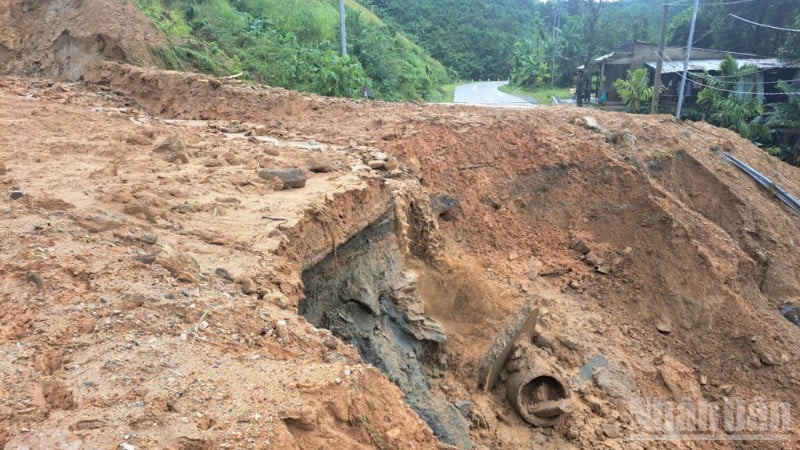
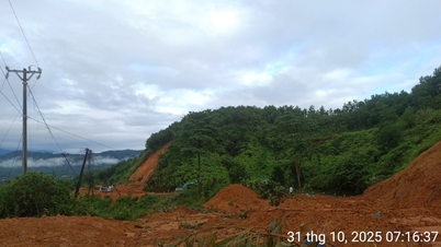
| Landslide on Truong Son road, east branch. |
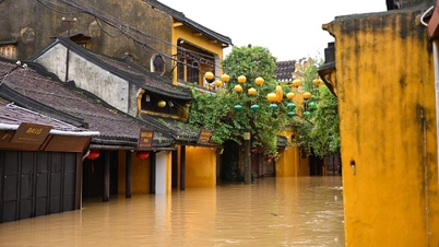
Central region: Many routes on Ho Chi Minh road have landslides.
According to Road Management Area II, moderate to heavy rains in waves from the night of October 31 to the morning of November 1 caused new landslides on the positive and negative slopes at 10 locations on the western branch of Ho Chi Minh Highway, passing through Hue City (from Km377+600 to Km386+300). These locations are currently completely blocked, and are expected to be temporarily opened to traffic on November 2, with a plan to divert traffic at both ends of the route.
On the La Son-Hoa Lien section (in Da Nang city), due to landslides and local flooding, traffic has been diverted to National Highway 1 to ensure smooth flow. In addition, two notable flooding spots include:
National Highway 1 through Quang Tri, section Km611+600-Km612+100, is currently flooded 15-20cm, vehicles are moving slowly in lanes close to the median strip;
Ho Chi Minh Road East Branch, section Km945+500-Km946+080, has been flooded 45cm deep since 7am this morning. Currently, authorities have organized traffic diversion at both ends.
Central Highlands: Continuous landslides, many roads cut off
Road Management Area III said that from the night of October 31 to the morning of November 1, heavy rain on the Truong Son Dong route through Da Nang-Quang Ngai area caused many new landslides.
On Lo Xo Pass, the section across Ho Chi Minh Highway, the landslides have been cleared to one lane, but there is a high risk of re-erosion due to continued rain. The management agency recommends that vehicles should follow Highway 19 and Highway 24 to connect the Central Highlands and Highway 1.
Notably, at Km1373+150, the Ho Chi Minh route had landslides four times in just three days (the first time at 8:25 am on October 28, the most recent time at 5:00 am on November 1), and it was not opened to traffic until 7:45 am this morning (November 1).
Currently, the west branch of Ho Chi Minh road still has 4 jammed locations including: Km415+230, Km415+560, Km433+620, Km437+650, expected to clear one lane before 11am today.
The Eastern Truong Son route is currently blocked at 22 locations; forces and machinery are being mobilized from both ends of Da Nang and Quang Ngai to urgently fix the problem.
Specifically, the traffic jam locations and expected time to clear the road:
Da Nang area has 10 remaining points, expected to temporarily open one lane from 5:00 p.m. today to 5:00 p.m. November 2.
Quang Ngai area has 12 remaining points, expected to be completed from 9:00 p.m. today to 11:00 a.m. on November 2.
The La Son-Hoa Lien section (Km41+400 and Km42+800) is expected to open to traffic at 5:00 p.m. on November 3. At Km50+700-Km50+800, cracks appeared along the road surface and traffic has been completely banned for investigation and treatment.
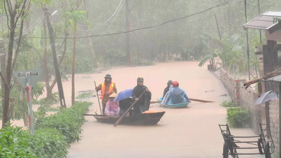
In Lam Dong province, water is gradually receding and traffic is initially open.
According to Road Management Area IV, at National Highway 1, section Km1700+000-Km1700+970 (Lam Dong province), the water started to recede from 1am this morning, and by 6am the route was temporarily cleared. Currently, section Km1700+500-Km1700+880 is still slightly flooded (0.1m at the center of the road, 0.3m on the shoulder), traffic is slow in both directions. Authorities continue to monitor and regulate.
According to the Department of Construction of Quang Tri, as of 6:00 a.m. on November 1, there were 22 traffic jams on national highways, of which 8 were deeply flooded, specifically:
On National Highway 9B, the water is 0.2m deep at Km41+900 and Km43+700; National Highway 15 is flooded at Km562+100, 0.9m deep, so the road is blocked at this location; at Km565+070, the water is 0.25m deep;
National Highway 12A is flooded at Km1+200-Km1+400, 0.3-0.5m deep, and this location is also currently blocked;
National Highway 49C is flooded at Km32+950-Km41+076, 25-70cm deep, causing traffic jams in this area.
Regarding landslides in Quang Tri province:
On National Highway 9C, there was a landslide at Km29+100 and Km38+400, with an estimated landslide volume of 3,100m³. However, authorities have made efforts to fix the problem and are now clearing the road here.
On National Highway 9B, a landslide occurred at Km77+700, the estimated landslide volume is about 3,500m³. Authorities are working hard to fix it and have cleared one lane.
On National Highway 9, the landslide at Km48+120-Km48+140 has an estimated volume of about 200m³. The road at this location is currently not open.
Road Management Areas and local authorities affirmed that they are mobilizing maximum human resources, vehicles, and machinery to fix the problem and ensure traffic safety in the shortest time.
Residents and drivers are advised not to travel to areas at risk of landslides and deep flooding, and to monitor updated information from authorities to proactively plan their journeys.
Source: https://huengaynay.vn/chinh-tri-xa-hoi/duong-ho-chi-minh-va-quoc-lo-1-nhieu-doan-te-liet-vi-mua-lu-159486.html


Comment (0)