

Many "abnormal" weather patterns
The National Center for Hydro-Meteorological Forecasting has just released an analysis and assessment of the weather over the past month (August 11 - September 10, 2025) and a forecast of the climate trend for the coming month (September 11 - October 10, 2025).
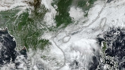
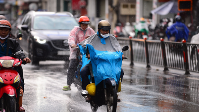
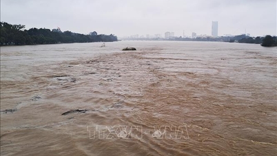
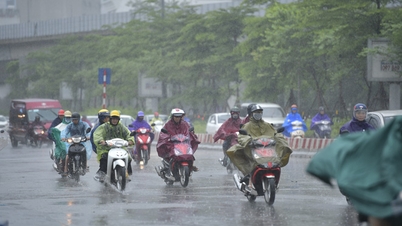
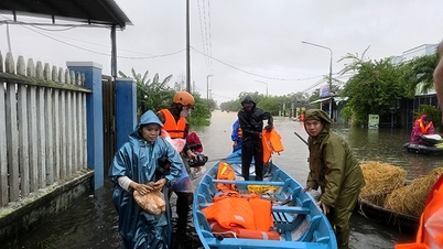
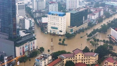
Accordingly, over the past month, the weather in our country has fluctuated strongly, with consecutive storms, tropical depressions, record-breaking heavy rains, and severe heat waves.
Ms. Tran Thi Chuc, Deputy Head of the Climate Forecasting Department, said that during this period, the East Sea had up to 3 storms and 1 tropical depression. Specifically, on the evening of August 16, the low pressure area south of Hoang Sa intensified into a tropical depression, then moved into Quang Ninh - Hai Phong on August 19 with winds of level 6, gusting to level 8 before weakening.
A few days later, storm No. 5 (international name Kajiki) formed, quickly strengthening to level 14, gusting to level 16 when approaching Hoang Sa. On August 25, the storm made landfall in the area of South Nghe An - North Ha Tinh , causing very heavy rain. Many places recorded rainfall from 200 - 400 mm, with Bai Thuong station (Thanh Hoa) alone reaching 543 mm.
Experts say this figure not only broke the August 2019 record but also surpassed the highest historical value ever recorded in 1994.
Soon after, storm No. 6 (Nongfa) formed on August 27, moved quickly and directly affected the Ha Tinh - Quang Tri area before dissipating in Laos. In September, storm No. 7 (Tapah) appeared in the Northeast of the East Sea, making landfall in Guangdong province (China) on September 8. Although the storm did not directly impact Vietnam, combined with the tropical convergence zone, it still caused widespread heavy rain in the North and some places in the North Central region.
Also last month, many rainy days appeared in the provinces and cities of the North. The prolonged rains caused a series of meteorological stations to record rainfall exceeding historical values. For example, on August 26, Ba Vi station (Hanoi) measured 299.8mm, higher than the historical mark of 258.7mm in 1978; Lang (Hanoi) 234.8mm, exceeding the record of 205.7mm in 1972; many other stations in Phu Tho, Ninh Binh, Thanh Hoa also broke the old record.
Not only floods, the North and Central regions also experienced heat waves. In particular, in the North, many places were over 37-38 degrees. Song Ma station (Son La) measured 38.5 degrees on September 5, surpassing the historical mark of 37.2 degrees. Hanoi also recorded 38.2 degrees at Lang station on September 8, breaking the record of 37.1 degrees in 2019.
In the Central region, the heat wave lasts from late July to mid-August, with temperatures reaching 37-38 degrees in many places. In the South, although widespread heat waves are rare, there are still some days when local temperatures reach 35-36 degrees...
Cold air begins to move in from the end of September
Experts said that in the next month (September 11 - October 10), the average temperature across the country is forecast to be approximately the average of many years; in the Northern region and Thanh Hoa - Ha Tinh, it will be about 0.5-1 degree higher.
Notably, cold air is forecast to appear from the end of September, but its intensity is still weak and its activity is unstable, so it has not caused significant changes in temperature regimes in the northern provinces.
In addition, the number of storms/tropical cyclones in the East Sea is at a similar level compared to the average of many years in the same period (2.2 storms in the East Sea, 1.1 storms making landfall in Vietnam) and may affect Vietnam's mainland.
Also during the forecast period, there is a possibility of some widespread heavy rains in the Northern Delta, Thanh Hoa - Quang Ngai. The Southern region and other areas in the Central region continue to have many days of thunderstorms, with some areas experiencing moderate to heavy rain. Particularly, the Northern Delta and the provinces from Thanh Hoa to Gia Lai have total rainfall generally 5-15% higher than the average of many years.
The meteorological agency warned that the combination of storms, tropical depressions and the southwest monsoon could cause strong winds and large waves at sea, directly affecting shipping activities.
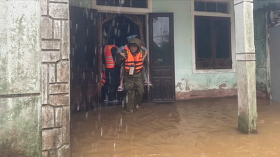
On land, heavy rains can cause flooding in low-lying areas and landslides in mountainous areas. Extreme events such as thunderstorms, tornadoes, lightning, hail, and strong winds can still occur in many places, negatively affecting agricultural production, transportation, and people's lives.
Experts recommend that authorities and people closely monitor the next forecasts and warnings. Proactive response plans, especially in areas at risk of flash floods, landslides, and coastal areas affected by storms, will help minimize damage.
PV (synthesis)Source: https://baohaiphong.vn/khong-khi-lanh-kha-nang-xuat-hien-tu-cuoi-thang-9-thoi-tiet-con-di-thuong-520574.html
![[Photo] Human love in the flood in Hue](https://vphoto.vietnam.vn/thumb/1200x675/vietnam/resource/IMAGE/2025/10/29/1761740905727_4125427122470875256-2-jpg.webp)


![[Photo] New-era Party members in the "Green Industrial Park"](https://vphoto.vietnam.vn/thumb/1200x675/vietnam/resource/IMAGE/2025/10/30/1761789456888_1-dsc-5556-jpg.webp)
![[Photo] Fall Fair 2025 - An attractive experience](https://vphoto.vietnam.vn/thumb/1200x675/vietnam/resource/IMAGE/2025/10/30/1761791564603_1761738410688-jpg.webp)
![[Photo] Prime Minister Pham Minh Chinh chaired a meeting to evaluate the operation of the two-level local government model.](https://vphoto.vietnam.vn/thumb/1200x675/vietnam/resource/IMAGE/2025/10/29/1761751710674_dsc-7999-jpg.webp)


Comment (0)