
Earthquake Information and Tsunami Warning Center, Institute of Earth Sciences has just issued an earthquake notice.
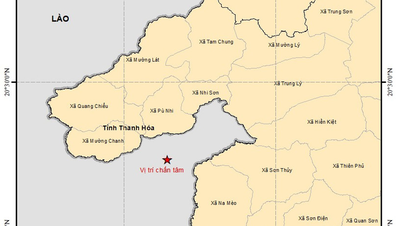
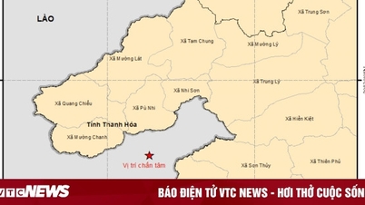
Accordingly, at 00:02:24 on November 17, a magnitude 3.9 earthquake occurred at the coordinates (20.374 degrees North latitude, 104.600 degrees East longitude), with a focal depth of about 16 km. The earthquake occurred in Houaphan province, Laos, about 2.5 km from the Vietnam border in Na Meo commune, Thanh Hoa province. The natural disaster risk level is level 0.
The Earthquake Information and Tsunami Warning Center - Institute of Earth Sciences is continuing to monitor this earthquake.

Previously, at 23:26:19, near this area, there was a 4.8 earthquake, focal depth 10km, level 1 natural disaster risk. The earthquake made many Vietnamese people in some provinces and cities feel the shaking clearly. Right in the capital Hanoi , many people expressed their worries when their houses, furniture and belongings were clearly shaken.
Houaphan Province (Laos) borders Thanh Hoa (Vietnam) and lies on the Ma River fault zone, stretching from Dien Bien, Lai Chau down to Quan Son (Thanh Hoa) and into Laos. This area often experiences small earthquakes due to the activity of the fault zone.
According to scientists, earthquakes of magnitude 4-5 are mild earthquakes but can still cause shaking, especially in high-rise buildings. These earthquakes usually cause no damage or only minor damage.
Source: https://baolaocai.vn/lai-dong-dat-manh-39-do-gan-bien-gioi-viet-nam-lao-post886947.html


![[Photo] General Secretary To Lam and National Assembly Chairman Tran Thanh Man attend the 80th Anniversary of the Traditional Day of the Vietnamese Inspection Sector](https://vphoto.vietnam.vn/thumb/1200x675/vietnam/resource/IMAGE/2025/11/17/1763356362984_a2-bnd-7940-3561-jpg.webp)


Comment (0)