
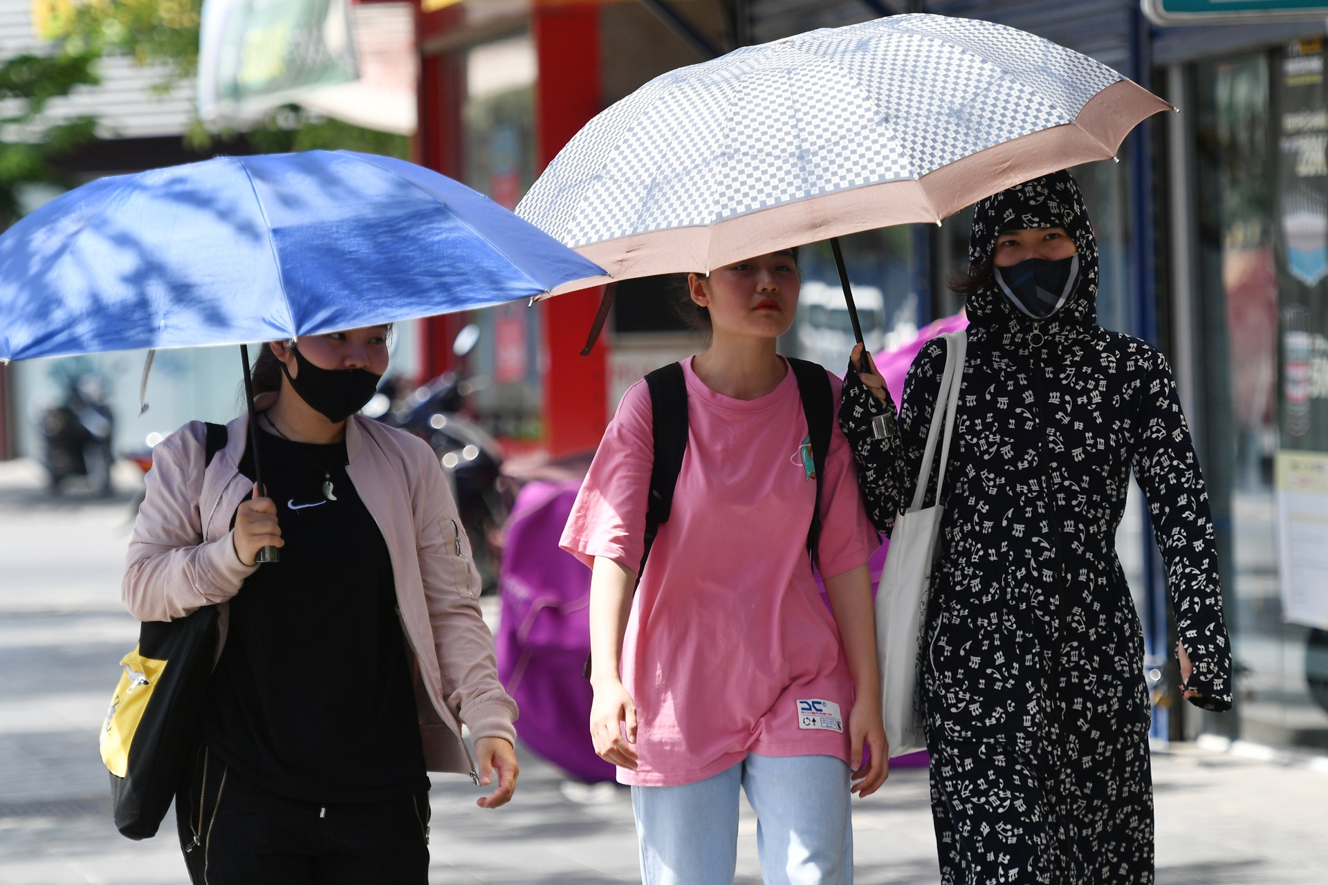
According to the National Center for Hydro-Meteorological Forecasting, due to the influence of a hot low-pressure area in the West and the Foehn wind effect, the midland and lowland areas of Northern Vietnam and Hoa Binh have experienced hot weather for nearly a week straight with maximum temperatures ranging from 36-39 degrees Celsius, and in some places exceeding 39 degrees Celsius.
Specifically, today (June 19th), the Northern Delta, Hoa Binh and Central regions experienced hot weather, with some areas experiencing intense heat. At 1 PM, temperatures exceeded 38 degrees Celsius in some places, such as Lang ( Hanoi ) 38.5 degrees, Tinh Gia (Thanh Hoa) 38.9 degrees, Do Luong (Nghe An) 38.6 degrees, Huong Khe (Ha Tinh) 38.4 degrees, etc.; the relative humidity at 1 PM was generally 45-55%.
On June 20-21, the Northern Delta region, Hoa Binh, and the area from Thanh Hoa to Thua Thien Hue will continue to experience hot and intensely hot weather, with some areas experiencing exceptionally intense heat. The highest temperatures will range from 36-39 degrees Celsius, with some places exceeding 39 degrees Celsius; the lowest relative humidity will be 40-45%.

In the mountainous and midland areas of Northern Vietnam and from Da Nang to Ninh Thuan, the heat has subsided somewhat, with maximum temperatures ranging from 35-38 degrees Celsius, and exceeding 38 degrees Celsius in some places; the lowest relative humidity is commonly 50-60%.
Forecasts indicate that from the night of June 22nd to 23rd, the Northern region will experience scattered showers and thunderstorms (concentrated in the late afternoon and evening), so from June 23rd onwards, the heatwave is expected to gradually subside.
This is the predicted temperature inside the weather station's tent; the actual temperature outside is 2-4 degrees hotter depending on the surface conditions such as concrete or asphalt roads.
For the Central region, hot and intensely hot weather, exceptionally severe in some areas, will continue for the next few days. Until June 22nd, hot and intensely hot weather will persist from Thanh Hoa to Thua Thien Hue; from around June 23rd-24th, the heat will tend to gradually decrease, with the possibility of scattered showers and thunderstorms from the evening of the 24th (rain concentrated in the late afternoon).
From Da Nang to Binh Thuan, on June 22nd, the northern areas will experience hot weather; from approximately the night of June 21st to 24th, there is a possibility of scattered showers and thunderstorms (rain concentrated in the late afternoon and evening).
Particular attention should be paid to areas that, after many days of scorching heat, need to be very cautious when thunderstorms occur, as there is a high possibility of tornadoes, lightning, hail, and strong gusts of wind. Localized heavy rain may cause flash floods on small rivers and streams, landslides on slopes, and flooding in low-lying areas. Be prepared for heavy rainfall in a short period of time that could cause flooding in urban areas.
Additionally, the Central Highlands and Southern regions will continue to experience sunny weather in the coming days, with some areas experiencing hot weather, but scattered showers and thunderstorms are possible in the late afternoon and evening, with localized heavy rain; specifically from around the evening of June 21-25, there will be scattered showers and thunderstorms, with localized heavy rain.
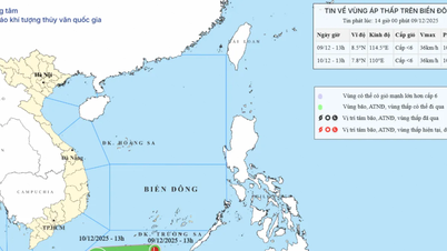
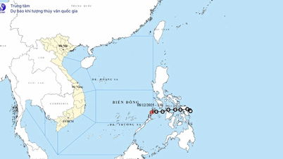
The possibility of a low-pressure system forming over the South China Sea.
In its 10-day weather forecast for Ho Chi Minh City (June 18-28), the Southern Region Meteorological and Hydrological Station assessed the weather patterns affecting the area. Specifically, over the next 24 hours, a low-pressure trough with its axis at approximately 24-27 degrees North latitude, connected to a developing and gradually expanding hot low-pressure area in the West, will continue to expand eastward. At higher altitudes, the subtropical high-pressure system over South Central Vietnam will persist. The Southwest monsoon will operate at a moderate intensity.
Over the next 2-10 days, a low-pressure trough with its axis at approximately 24-27 degrees North latitude will connect with a hot low-pressure area to the West, which will gradually fill up.
Notably, from around June 23rd, a low-pressure trough with its axis passing through the Northern region of Vietnam is gradually becoming more active, with the possibility of tropical cyclones forming in the northern part of the South China Sea.
According to this meteorological station, with these weather patterns, Ho Chi Minh City will experience continuous rain with a probability of 65-75%.
Additionally, during today and tonight, in the central and southern South China Sea (including the waters around the Spratly Islands), the sea area from Ca Mau to Kien Giang, and the Gulf of Thailand, there will be heavy rain and thunderstorms. During thunderstorms, there is a possibility of tornadoes and strong gusts of wind (level 6-7), and be prepared for waves that may reach over 2 meters in height.
The sea area from Binh Thuan to Ca Mau will experience heavy rain and thunderstorms, strong southwest winds of level 5, sometimes level 6, gusting to level 7-8; rough seas; wave height from 1.5-2.5m.
All vessels operating in these areas are at high risk of being affected by tornadoes, strong winds, and large waves.
Source: https://vietnamnet.vn/mien-bac-nang-nong-dinh-diem-kha-nang-co-xoay-thuan-nhiet-doi-o-bien-dong-2293077.html

![[Photo] Prime Minister Pham Minh Chinh attends the Conference summarizing and implementing tasks of the judicial sector.](/_next/image?url=https%3A%2F%2Fvphoto.vietnam.vn%2Fthumb%2F1200x675%2Fvietnam%2Fresource%2FIMAGE%2F2025%2F12%2F13%2F1765616082148_dsc-5565-jpg.webp&w=3840&q=75)


Comment (0)