

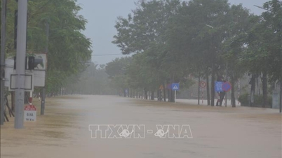
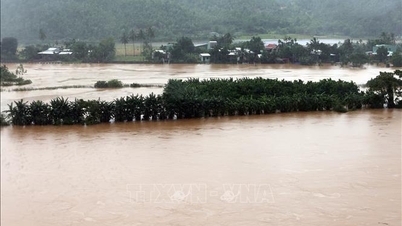
The weather in the Central region is still heavy rain, floods continue to rise - Photo: TN
The National Center for Hydro-Meteorological Forecasting said that from last night, today until the end of tomorrow, October 29, the weather from southern Quang Tri to Da Nang city and eastern Quang Ngai province will have heavy to very heavy rain.
Rainfall in southern Quang Tri and eastern Quang Ngai provinces is forecast to reach 200 - 400mm, with some places over 700mm. In Hue City and Da Nang City, it is generally 300 - 500mm, with some places over 800mm.
From Ha Tinh to northern Quang Tri, there will be moderate to heavy rain and thunderstorms. Rainfall is generally 100 - 200mm, with some places experiencing very heavy rain over 350mm. Warning of the risk of rain intensity greater than 200mm/3 hours.
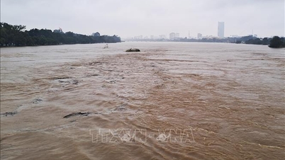
Currently, floods on the Huong River (Hue City), Vu Gia and Thu Bon Rivers (Da Nang City) are rising rapidly. Rivers in southern Quang Tri and Quang Ngai are rising.
In the next 12 hours, floods on rivers in Hue and Da Nang will continue to rise rapidly. On the Bo River at Phu Oc station, the level will rise 0.2 - 0.3m above the historical level in 2020. On the Huong River at Kim Long station, Vu Gia River at Ai Nghia station, Thu Bon River at Cau Lau station will continue to rise and be above alert level 3 by 0.6 - 1.3m. Floods on the Tra Khuc River will continue to rise and be below alert level 3.
Warning of high risk of widespread flooding in Hue and Da Nang cities, flash floods on rivers and streams and landslides on slopes in provinces from Quang Tri to Quang Ngai.
In Ho Chi Minh City, from 7pm on October 27 to 7pm on October 29, there will be moderate rain, heavy rain and thunderstorms. Total rainfall will be 70-150mm, with some places exceeding 150mm.
During the night of October 29, Ho Chi Minh City continued to experience moderate to heavy rain and thunderstorms. The total rainfall from 7 p.m. to the end of October 29 was generally 30-80mm. From October 30, the rain gradually decreased in both area and volume.
The South and other regions will have moderate to scattered rain with thunderstorms, with some places experiencing heavy to very heavy rain. Thunderstorms may include tornadoes, lightning, hail, and strong gusts of wind.
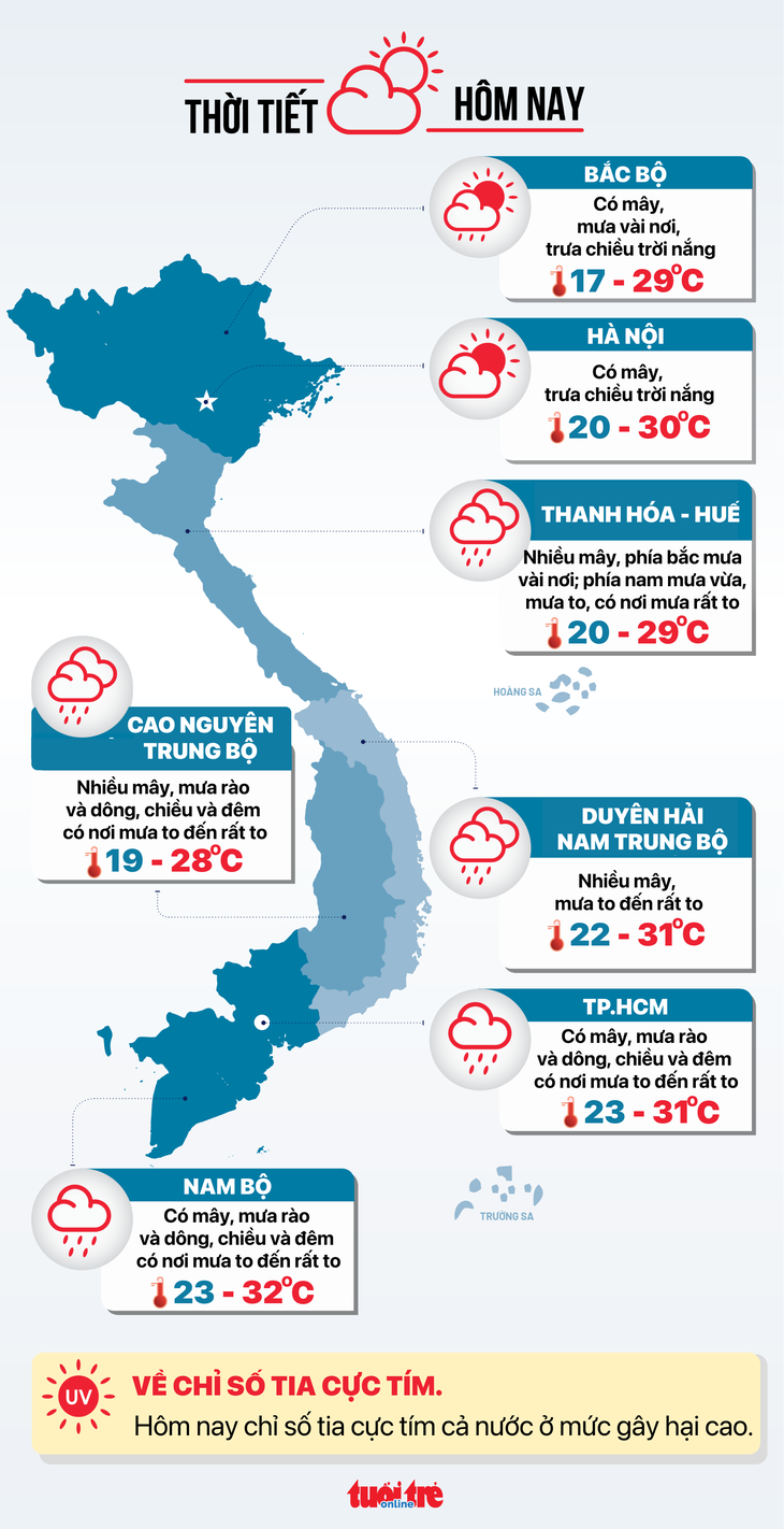
Detailed weather forecast today October 28:
Hanoi is cloudy, sunny in the afternoon. Lowest temperature 20-22 degrees Celsius, highest 28-30 degrees Celsius.
Northwest region is cloudy, rain in some places, sunny in the afternoon. Lowest temperature 17-21 degrees Celsius, highest 26-29 degrees Celsius.
Northeast region is cloudy, rain in some places, sunny in the afternoon. Lowest temperature 18-22 degrees Celsius, highest 26-29 degrees Celsius.
From Thanh Hoa to Hue , it is cloudy, with some rain in the north; moderate rain, heavy rain, and very heavy rain in some places in the south. Lowest temperature 20-23 degrees Celsius, highest 27-29 degrees Celsius.
South Central Coast cloudy, heavy to very heavy rain. Lowest temperature 22-25 degrees Celsius, highest 29-31 degrees Celsius.
Central Highlands cloudy, scattered showers and thunderstorms, heavy rain in some places in the afternoon and at night. Lowest temperature 19-22 degrees Celsius, highest 25-28 degrees Celsius.
The South has clouds, showers and thunderstorms, heavy rain in some places in the afternoon and at night. Lowest temperature 23-26 degrees Celsius, highest 29-32 degrees Celsius.
Ho Chi Minh City is cloudy with scattered showers and thunderstorms. Heavy rain in some places in the afternoon and at night. Lowest temperature 23-25 degrees Celsius, highest 29-31 degrees Celsius.
Weather forecast today October 28 - Graphics: NGOC THANH
Source: https://tuoitre.vn/thoi-tiet-hom-nay-28-10-mien-trung-van-mua-rat-to-nguoi-dan-oan-minh-voi-lu-20251027211352297.htm
![[Photo] Flooding on the right side of the gate, entrance to Hue Citadel](https://vphoto.vietnam.vn/thumb/1200x675/vietnam/resource/IMAGE/2025/10/28/1761660788143_ndo_br_gen-h-z7165069467254-74c71c36d0cb396744b678cec80552f0-2-jpg.webp)


![[Photo] Draft documents of the 14th Party Congress reach people at the Commune Cultural Post Offices](https://vphoto.vietnam.vn/thumb/1200x675/vietnam/resource/IMAGE/2025/10/28/1761642182616_du-thao-tai-tinh-hung-yen-4070-5235-jpg.webp)

![[Photo] National Assembly Chairman Tran Thanh Man received a delegation of the Social Democratic Party of Germany](https://vphoto.vietnam.vn/thumb/1200x675/vietnam/resource/IMAGE/2025/10/28/1761652150406_ndo_br_cover-3345-jpg.webp)


![[Photo] President Luong Cuong attends the 80th Anniversary of the Traditional Day of the Armed Forces of Military Region 3](https://vphoto.vietnam.vn/thumb/1200x675/vietnam/resource/IMAGE/2025/10/28/1761635584312_ndo_br_1-jpg.webp)


Comment (0)