
According to the National Center for Hydro-Meteorological Forecasting, during the day and night of May 22, many areas will have hot weather, some places will have extremely hot weather, and thunderstorms in the evening and at night. Be careful during thunderstorms, there is a possibility of tornadoes, lightning, hail and strong gusts of wind.
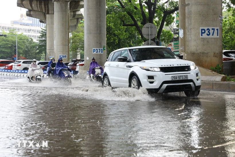
Northern and North Central regions have very heavy rain.
Commenting on the rain situation, Deputy Head of Weather Forecast Department, National Center for Hydro-Meteorological Forecasting Nguyen Huu Thanh said that from the night of May 22 to the night of May 23, the Northern region will have moderate rain, heavy rain, thunderstorms, locally very heavy rain with common rainfall of 60-120mm, locally over 180mm. Warning of the risk of localized heavy rain over 100mm in 3 hours
In the evening and night of May 23, in the North Central region, there will be moderate rain, heavy rain and thunderstorms, locally very heavy rain with common rainfall of 20-50mm, locally over 80mm.
In addition, in the evening and night of May 22, Ninh Thuan - Binh Thuan , Central Highlands and the South will have rain, moderate rain and scattered thunderstorms, locally heavy rain with rainfall from 20-40mm, locally over 70mm, in thunderstorms there is a possibility of tornadoes, lightning, hail and strong gusts of wind.
Warning, heavy rain in the Northern region is likely to last until around May 24 with common rainfall from 15-40mm, some places over 70mm, from the night of May 24 heavy rain in the Northern region tends to decrease gradually.
During the day and night of May 24, the North Central region will have moderate to heavy rain, with some places experiencing very heavy rain with rainfall ranging from 20-50mm, with some places experiencing over 80mm. During thunderstorms, there is a possibility of tornadoes, lightning, hail and strong gusts of wind.
Warning level 1 natural disaster risk due to heavy rain.
Heavy rains are likely to cause flooding in low-lying areas, urban and industrial areas; flash floods on small rivers and streams, landslides on steep slopes (real-time warning information on areas at risk of flash floods and landslides is provided online on the website of the Department of Hydrometeorology at: https://luquetsatlo.nchmf.gov.vn and in separate bulletins warning of flash floods and landslides).
Risk of flash floods and landslides in Dak Nong
Along with that, the National Center for Hydro-Meteorological Forecasting informed that from 3:30 a.m. to 8:30 a.m. on May 22, the Dak Nong province continued to have rain with common rainfall ranging from 20-59mm, in some places over 70mm.
Risk of flash floods on small rivers and streams, landslides on steep slopes in the above provinces, especially in the districts of Cu Jut, Dak Glong, Dak Mil, Dak R'Lap, Dak Song, Gia Nghia city, Tuy Duc. Warning level of natural disaster risk due to flash floods, landslides, land subsidence due to heavy rain or level 1 flow.
Flash floods and landslides can have very negative impacts on the environment, threaten people's lives; cause local traffic congestion, affect the movement of vehicles; destroy civil and economic works, causing damage to production and socio-economic activities.
The hydrometeorological agency reminds people to regularly monitor forecast and warning information on the website of the National Center for Hydro-Meteorological Forecasting at nchmf.gov.vn, and provincial, municipal and regional hydrometeorological stations.
At the same time, regularly update the latest hydrometeorological forecast information on the official mass media of the Central and local levels to proactively respond, and at the same time recommend that the authorities in the affected localities pay attention to reviewing the flow bottlenecks and vulnerable locations in the area to take preventive measures.
According to the guidance of the Department of Dyke Management and Natural Disaster Prevention and Control (Ministry of Agriculture and Environment), in the face of the above situation, affected areas should closely monitor developments of heavy rain, floods, flash floods, landslides, and promptly and fully inform authorities at all levels and people to proactively prevent, respond, and minimize damage.
Localities deploy shock forces to inspect and review residential areas along rivers, streams, and low-lying areas to proactively organize the relocation and evacuation of people in areas at high risk of deep flooding, flash floods, and landslides; organize forces ready to control and direct traffic, and place warning signs, especially through culverts, spillways, and areas with deep flooding and fast-flowing water; proactively arrange forces, materials, and means to overcome incidents, ensuring smooth traffic on main traffic routes when heavy rain occurs...
From 0:00 to 2:00 on May 22, Dak Nong province had rain, some places had moderate to heavy rain such as: Dak Wer 53.4mm, Dak Buk So 47.6mm,...
Soil moisture models show that some areas in the province are close to saturation (over 85%) or have reached saturation.
Many coastal areas have thunderstorms
Regarding the weather situation at sea, Mr. Nguyen Huu Thanh said that currently the sea area from Binh Thuan to Ca Mau, Ca Mau to Kien Giang, and the Gulf of Thailand has scattered showers and thunderstorms.
It is forecasted that on the day and night of May 22, in the sea area from Binh Thuan to Ca Mau, Ca Mau to Kien Giang, the Gulf of Thailand, the central and southern East Sea (including the sea area of Truong Sa), there will be scattered showers and thunderstorms, with the possibility of tornadoes and strong gusts of wind of level 6-7.
All vessels operating in the above areas are at risk of being affected by tornadoes and strong gusts of wind.
According to the guidance of the Ministry of Agriculture and Environment, coastal provinces and cities affected by the storm must closely monitor warning bulletins, forecasts and developments of strong winds at sea; notify captains and owners of vehicles and vessels operating at sea to proactively prevent and have appropriate production plans, ensuring safety of people and property; maintain communication to promptly handle possible bad situations.
Weather in regions day and night 5/22
Northwest
- Sunny day, hot in some places, showers and thunderstorms in the evening; moderate rain, heavy rain and thunderstorms at night, locally very heavy rain in some places, thunderstorms with possibility of tornadoes, lightning, hail and strong gusts of wind.
- Lowest temperature 24-27 degrees Celsius, in the Northwest region 21-24 degrees Celsius, some places below 21 degrees Celsius. Highest temperature 32-35 degrees Celsius, some places above 36 degrees Celsius.
Northeast:
- Sunny day, hot in some places, showers and thunderstorms in the evening; moderate rain, heavy rain and thunderstorms at night, locally very heavy rain in some places, thunderstorms with possibility of tornadoes, lightning, hail and strong gusts of wind. Southeast to South wind level 2-3.
- Lowest temperature 24-27 degrees Celsius. Highest temperature 32-35 degrees Celsius.
Hanoi capital
- Sunny day, hot in some places, showers and thunderstorms in the evening; moderate rain, heavy rain and thunderstorms at night, locally very heavy rain in some places. Southeast to South wind level 2-3.
- Lowest temperature 25-27 degrees Celsius. Highest temperature 33-35 degrees Celsius.
Provinces and cities from Thanh Hoa to Hue
- Hot during the day, with some places experiencing intense heat; showers and thunderstorms in the late afternoon and at night in some places, with scattered showers and thunderstorms in Thanh Hoa and Nghe An. Thunderstorms may include tornadoes, lightning, hail and strong gusts of wind.
- Lowest temperature 25-28 degrees Celsius. Highest temperature 34-37 degrees Celsius, some places above 37 degrees Celsius.
Provinces and cities from Da Nang to Binh Thuan
- In the North, it is hot and sunny during the day, with some places experiencing intense heat. In the afternoon and evening, there will be scattered showers and thunderstorms. In the South, it will be sunny during the day, with scattered showers and thunderstorms in the afternoon and evening, with some places experiencing moderate to heavy rain. During thunderstorms, there is a possibility of tornadoes, lightning, hail, and strong gusts of wind.
- Lowest temperature 25-28 degrees Celsius. Highest temperature in the North 34-36 degrees Celsius, some places above 36 degrees Celsius, South 32-35 degrees Celsius.
Central Highlands region
- There will be showers and thunderstorms in some places, especially in the afternoon and at night, moderate rain and scattered thunderstorms, locally heavy rain in some places, in thunderstorms there is a possibility of tornadoes, lightning, hail and strong gusts of wind.
- Lowest temperature 20-23 degrees Celsius. Highest temperature 29-32 degrees Celsius. Some places above 32 degrees Celsius.
Southern Region
- There will be showers and thunderstorms in some places; in the afternoon and at night there will be rain, moderate rain and scattered thunderstorms, locally heavy rain in some places, in thunderstorms there is a possibility of tornadoes, lightning, hail and strong gusts of wind.
- Lowest temperature 24-27 degrees Celsius. Highest temperature 31-34 degrees Celsius, some places above 34 degrees Celsius./.
Source (Vietnam News Agency/Vietnam+)
Source: https://baophutho.vn/thoi-tiet-ngay-22-5-bac-bo-ngay-co-nang-nong-chieu-toi-va-dem-mua-dong-233117.htm
![[Photo] Prime Minister Pham Minh Chinh receives Rabbi Yoav Ben Tzur, Israeli Minister of Labor](https://vphoto.vietnam.vn/thumb/1200x675/vietnam/resource/IMAGE/2025/5/21/511bf6664512413ca5a275cbf3fb2f65)
![[Photo] Determining the pairs in the team semi-finals of the National Table Tennis Championship of Nhan Dan Newspaper](https://vphoto.vietnam.vn/thumb/1200x675/vietnam/resource/IMAGE/2025/5/21/eacbf7ae6a59497e9ae5da8e63d227bf)


![[Photo] Prime Minister Pham Minh Chinh attends the groundbreaking ceremony of Trump International Hung Yen Project](https://vphoto.vietnam.vn/thumb/1200x675/vietnam/resource/IMAGE/2025/5/21/ca84b87a74da4cddb2992a86966284cf)


Comment (0)