

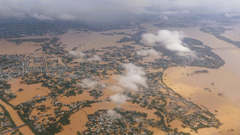
Floods on the Thu Bon River in Hoi An may exceed the historic flood level of 1964.
The Central Region Hydrometeorological Station said that the water level on the Vu Gia - Thu Bon River and the Tam Ky River is rising rapidly again. At 1 p.m. on October 29, the water level on the Vu Gia, Thu Bon, and Han rivers was above level 3, and the Tam Ky River was above level 2.
It is forecasted that in the next 6-18 hours, the flood on Vu Gia - Thu Bon river will continue to rise. The flood peak on Vu Gia river at Ai Nghia is likely to reach 10.6-10.80m, on BĐ3: 1.60-1.80m - at a level close to the historical flood (Hmaxls 10.77m in 2009).
The flood peak on Thu Bon River at Cau Lau reached 5.45-5.5m on BĐ3: 1.45-1.5m - at a level approximately equal to the historical flood (Hmaxls 5.48m - 1964), at Hoi An it reached 3.5m on BĐ3: 15m - at a level 0.1m higher than the historical flood (Hmaxls 3.40m in 1964).
Han River reaches level above BĐ3, Tam Ky River fluctuates at level BĐ2-BĐ3.
In the next 18-24 hours, flood on Vu Gia Thu Bon river will slowly recede, but will remain at a high level; Tam Ky river will fluctuate at level BĐ1-BĐ2.
Severe widespread flooding continues to occur in low-lying areas along rivers and inundation in urban areas. Especially in the communes of Que Phuoc, Nong Son, Que Son, Tam Xuan, Lanh Ngoc, Duy Xuyen, Thu Bon, Xuan Phu, Thanh My, Thuong Duc, Ha Nha, Phu Thuan, Vu Gia, Dai Loc, Go Noi, Dien Ban Tay, Dien Ban Bac, Hoa Tien, Hoi An, Hoi An Tay, Hoi An Dong, Nam Phuoc, Duy Nghia, An Thang, Ban Thach Ward, Huong Tra Ward, Quang Phu Ward, Tay Ho Commune, Thang Dien, Thang Truong, Que Xuan, Hoa Xuan, Ngu Hanh Son, Cam Le, Ba Na, Thang An, Thu Bon, Hoa Vang, Hai Van...
There is a very high risk of flash floods and landslides on steep slopes in mountainous areas of Da Nang city.


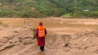
Floodwaters deeply inundated Thanh My commune, Da Nang city today (October 29)
Heavy rain continues in Da Nang city
According to the Central Hydrometeorological Station, from this evening (October 29) to the night of October 30, in the communes and wards of Da Nang city, there will be heavy rain, very heavy rain and thunderstorms. The total rainfall in the wards and communes in the plains is generally 100-200mm, in some places over 300mm; in the communes and wards in the mountainous areas, it is generally 100-250mm, in some places over 400mm. Warning of the risk of heavy rain >150mm/3 hours in the mountainous areas.
The entire city has 10 communes and wards completely isolated: Go Noi, Thuong Duc, Vu Gia, Ha Nha, Dai Loc, Nong Son, Que Phuoc, Duy Xuyen, Thu Bon, Phu Thuan.
29 communes and wards were heavily flooded, including: Hai Van, Hoa Xuan, Hoa Tien, Lien Chieu, Ngu Hanh Son, Hoa Vang, Ba Na, Thanh My, Phuoc Tra, Viet An, Son Cam Ha, Xuan Phu, Thang An, Thang Dien, Thang Binh, Thang Phu, Dong Duong, Quang Phu, Tay Ho, Phu Ninh, Dien Ban Tay, Duy Xuyen, Nam Phuoc, An Thang, Hoi An, Hoi An Tay, Hoi An Dong, Duy Nghia, Dien Ban, Dien Ban Bac.
To ensure safety, communes and wards have evacuated 4,835 households/15,886 people.
Nhat Anh
Source: https://baochinhphu.vn/toi-nay-lu-tren-song-thu-bon-tai-hoi-an-co-the-vuot-moc-lu-lich-su-nam-1964-102251029161642905.htm


![[Photo] Standing member of the Secretariat Tran Cam Tu visits and encourages people in the flooded areas of Da Nang](https://vphoto.vietnam.vn/thumb/1200x675/vietnam/resource/IMAGE/2025/10/30/1761808671991_bt4-jpg.webp)

![[Photo] Fall Fair 2025 - An attractive experience](https://vphoto.vietnam.vn/thumb/1200x675/vietnam/resource/IMAGE/2025/10/30/1761791564603_1761738410688-jpg.webp)


![[Photo] New-era Party members in the "Green Industrial Park"](https://vphoto.vietnam.vn/thumb/1200x675/vietnam/resource/IMAGE/2025/10/30/1761789456888_1-dsc-5556-jpg.webp)


Comment (0)