
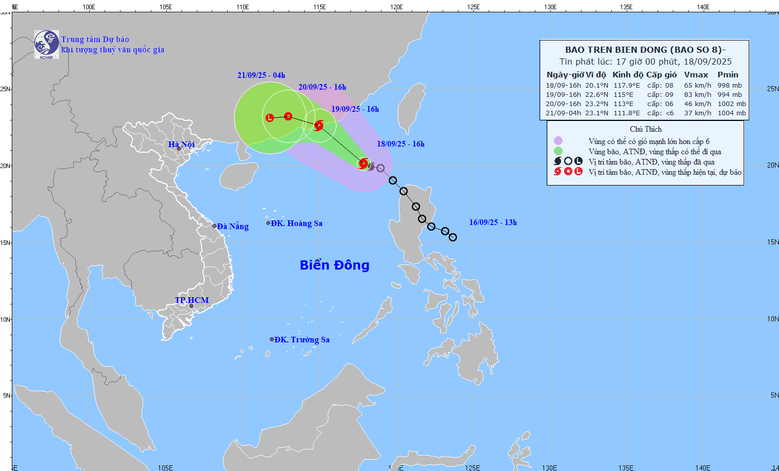
Accordingly, at noon on September 18, the tropical depression intensified into a storm (storm number 8). At 4:00 p.m. on September 18, the center of the storm was at about 20.1 degrees North latitude; 117.9 degrees East longitude, in the northeastern sea area of the North East Sea. The strongest wind near the center of the storm was level 8 (62-74 km/h), gusting to level 10. Moving northwest at a speed of 15-20 km/h and continuing to strengthen.
To proactively respond to the storm, the National Steering Committee for Civil Defense requested ministries, branches and People's Committees of coastal provinces and cities from Quang Ninh to Dak Lak to closely monitor the storm's developments; strictly manage vessels going out to sea; organize counting and notify owners of vessels and captains of ships and boats operating at sea of the location, direction of movement and developments of the storm to proactively avoid, escape or not move into dangerous areas. Dangerous areas in the next 24 hours: North of latitude 18.5 North; East of longitude 113.5 East (dangerous areas are adjusted in forecast bulletins).
Ministries, branches and localities are ready with forces and means for rescue when required. Ministries and branches, according to their functions, state management tasks and assigned tasks, proactively direct and coordinate with localities to respond to storms. At the same time, organize serious on-duty shifts and regularly report to the National Civil Defense Steering Committee (through the Ministry of Agriculture and Environment ).
Vietnam News Agency, Vietnam Television, Voice of Vietnam , the coastal information station system and mass media agencies from central to local levels should increase information about the storm's developments to authorities at all levels, owners of vehicles operating at sea and people to proactively respond.
Source: https://baotintuc.vn/xa-hoi/tu-quang-ninh-den-dak-lak-chu-dong-ung-pho-voi-bao-so-8-20250918174757271.htm


![[Photo] Panorama of the Patriotic Emulation Congress of Nhan Dan Newspaper for the period 2025-2030](https://vphoto.vietnam.vn/thumb/1200x675/vietnam/resource/IMAGE/2025/11/04/1762252775462_ndo_br_dhthiduayeuncbaond-6125-jpg.webp)


![[Photo] Opening of the 14th Conference of the 13th Party Central Committee](https://vphoto.vietnam.vn/thumb/1200x675/vietnam/resource/IMAGE/2025/11/05/1762310995216_a5-bnd-5742-5255-jpg.webp)


Comment (0)