
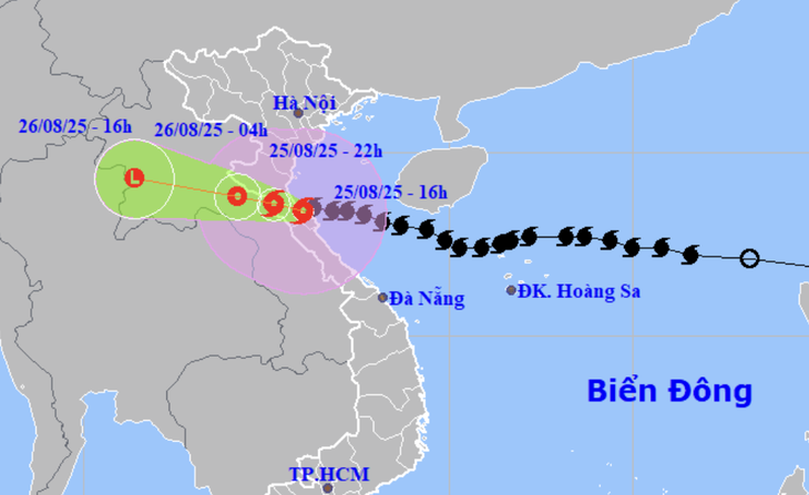
Location and trajectory of Typhoon No. 5 at 4 PM on August 25 - Photo: NCHMF
According to the National Center for Hydro-Meteorological Forecasting, this afternoon (13:00 - 16:00) Typhoon No. 5 will move very little, its intensity will decrease to level 12 (118-133 km/h), with gusts up to level 14.
Forecasts indicate that in the next 3-6 hours, Typhoon No. 5 will move in a west-northwest direction, making landfall in the northern Ha Tinh - southern Nghe An area. The risk of strong winds from Typhoon No. 5 remains.
Mr. Nguyen Van Huong, head of the weather forecasting department at the National Center for Hydro-Meteorological Forecasting, said that by 3 PM this afternoon, the storm's intensity had decreased to level 12 – a drop of two levels compared to 1 PM this afternoon.
According to Mr. Huong, the reason for the weakening of the storm is that as it approached the shore, it encountered friction with the terrain. In addition, since yesterday, there has been rain in the coastal areas of Central Vietnam, causing the sea surface temperature to decrease, thus reducing the energy supplied to the storm.
Mr. Huong predicted that in the next 1-3 hours, the storm will move in a west-northwest direction, making landfall in southern Nghe An and northern Ha Tinh with an intensity of level 11-12, gusting to level 14-15.
The storm then moved inland into Ha Tinh and Nghe An provinces before shifting to upper Laos and gradually weakening.
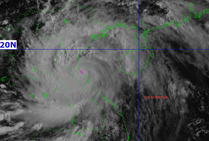
Satellite cloud imagery of Typhoon No. 5 at 4 PM on August 25th - Photo: NCHMF
"Given these developments, we predict that this afternoon, southern Nghe An and Ha Tinh will experience strong winds of level 11-12, gusting to level 14-15, while northern Nghe An, Thanh Hoa, and northern Quang Tri will have strong winds of level 8-9."
"On the sea from Thanh Hoa to Quang Tri, strong winds of level 8-9 continue, near the storm's center level 10-12, gusts of level 14-15, and sea waves remain 4-7m high," Mr. Huong informed.
Mr. Huong also stated that the storm's center is currently moving inland, resulting in a period of calm winds. However, this doesn't mean the wind has weakened; rather, after the storm passes, the post-storm circulation will resume, causing strong winds, possibly even stronger than before. Therefore, residents of Nghe An and Ha Tinh provinces need to be extremely aware of the wind changes as the storm's center approaches.
In addition, heavy rain is expected to continue in the area from Thanh Hoa to Quang Tri. Heavy rain, with rainfall of 150-300mm and over 500mm in some areas, is expected to continue until early tomorrow morning, posing a risk of flash floods and landslides in the western mountainous regions from Thanh Hoa to Quang Tri.
Ha Tinh experienced strong winds of level 9, gusting to level 12.
Due to the influence of typhoon No. 5, Cam Nhượng (Ha Tinh) experienced strong winds of level 9, gusting to level 12; Dien Chau (Nghe An) experienced strong winds of level 9, gusting to level 11; Ky Anh (Ha Tinh) experienced strong winds of level 8, gusting to level 11...
In the provinces of the Northern Delta, from Thanh Hoa to Quang Tri, there has been moderate to heavy rain, with some areas receiving very heavy rain exceeding 500mm.
Data from the disaster monitoring system shows that Ha Tinh experienced very heavy rainfall, with some areas receiving 300-500mm, such as Thuong Tuy Lake (478mm), Ky Phong (469mm), Ky Lam and Ky Son (426mm), Song Rac Lake (373mm), Thach Xuan (360mm), Cam Xuan and Ky Bac (349mm)...
Source: https://tuoitre.vn/vi-sao-gio-bao-so-5-giam-hai-cap-truc-khi-cap-bo-20250825165511479.htm

![[Photo] Prime Minister Pham Minh Chinh attends the Conference summarizing and implementing tasks of the judicial sector.](/_next/image?url=https%3A%2F%2Fvphoto.vietnam.vn%2Fthumb%2F1200x675%2Fvietnam%2Fresource%2FIMAGE%2F2025%2F12%2F13%2F1765616082148_dsc-5565-jpg.webp&w=3840&q=75)


Comment (0)