
Latest tropical depression news
While the whole country is joining hands with the northern provinces and cities to overcome the consequences of storm No. 3 and its circulation, a tropical depression is appearing near the East Sea, which is likely to strengthen into storm No. 4 this year.
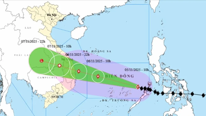
Update on the latest tropical depression news from the National Center for Hydro-Meteorological Forecasting, this morning (September 17) , the tropical depression has entered the eastern sea area of the North East Sea.
At 10:00 a.m. , the center of the tropical depression was at about 16.9 degrees North latitude; 119.9 degrees East longitude, in the eastern sea of the North East Sea. The strongest wind near the center of the tropical depression was level 7 (50-61 km/h), gusting to level 9; moving mainly in a westerly direction at a speed of about 20 km/h.
It is forecasted that in the next 24 to 48 hours, the tropical depression will likely strengthen into a storm, level 8-9 intensity, gusting to level 10-11.
Forecast time | Direction, speed | Location | Intensity | Danger zone | Disaster Risk Level (Affected Area) |
10:00 a.m. September 18 | West Southwest, about 20-25km/h, strengthening into a storm | 16.4 N-114.5E; about 320km east of Hoang Sa archipelago | Level 8, level 10 | 15.0N-19.0N; East of longitude 113.0E | Level 3: North East Sea area |
10:00 a.m. September 19 | West, 15-20km/h | 16.5N-110.5E; in the area west of Hoang Sa archipelago | Level 9, level 11 | 15.0N-19.0N; 108.5E-116.0E | Level 3: North East Sea area (including Hoang Sa archipelago area); sea area from Quang Tri to Quang Ngai |
In the next 48 to 72 hours, the storm is likely to change direction, moving in a West-Northwest direction, traveling about 10 km per hour .
Forecasting the impact of tropical depressions/storms
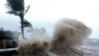
At sea: The eastern sea of the North East Sea has strong winds of level 6-7, the area near the storm center has winds of level 8 (62-74km/h), gusts of level 10 (89-102km/h), rough seas.
The eastern sea area of the North East Sea has waves 2.0-4.0m high, increasing to 3.0-5.0m from the afternoon and night of September 17. Ships operating in the above-mentioned dangerous areas are likely to be affected by strong winds and large waves.
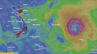
Commenting on this tropical depression, Mr. Nguyen Van Huong, Head of Weather Forecast Department, National Center for Hydro-Meteorological Forecasting, informed that after moving into the East Sea, around September 18, the tropical depression will become storm number 4 in 2024.
Forecast of 2 scenarios when the tropical depression strengthens into a storm and moves into the Hoang Sa archipelago, it will affect the Central Central region or the North and North Central region.
"All Vietnamese and international forecasts say that the intensity of storm No. 4 cannot be as strong as storm No. 3. If scenario 2 is followed, the storm will affect the mainland this weekend; but if scenario 1 is followed, the storm will impact 1-2 days earlier," Mr. Huong added.
Source: https://danviet.vn/moi-nhat-ap-thap-nhiet-doi-gan-bien-dong-dang-manh-cap-may-huong-di-nhu-the-nao-20240917112109268.htm
![[Photo] Heavy damage after storm No. 13 in Song Cau ward, Dak Lak province](https://vphoto.vietnam.vn/thumb/1200x675/vietnam/resource/IMAGE/2025/11/08/1762574759594_img-0541-7441-jpg.webp)


![[Photo] "Ship graveyard" on Xuan Dai Bay](https://vphoto.vietnam.vn/thumb/1200x675/vietnam/resource/IMAGE/2025/11/08/1762577162805_ndo_br_tb5-jpg.webp)


![[Video] Hue Monuments reopen to welcome visitors](https://vphoto.vietnam.vn/thumb/402x226/vietnam/resource/IMAGE/2025/11/05/1762301089171_dung01-05-43-09still013-jpg.webp)


Comment (0)