
This afternoon, September 16, the National Center for Hydro-Meteorological Forecasting warned that a tropical depression is active in the sea east of Luzon Island (Philippines).
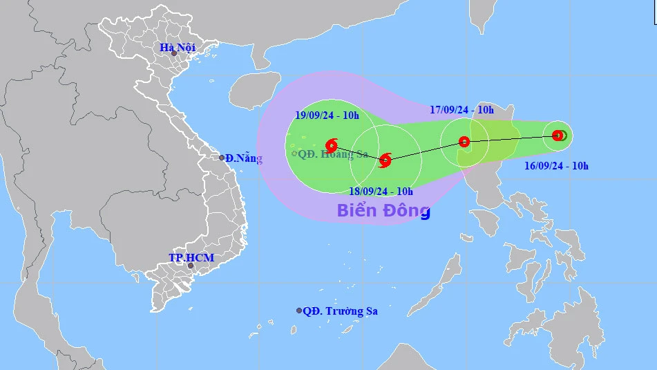
At 10:00 a.m. on September 16, the center of this tropical depression was at coordinates 17.1 degrees North latitude and 124.4 degrees East longitude, with strong winds of level 6-7, gusting to level 9, moving west at a speed of 15km/hour.
It is forecasted that in the next 24-48 hours, the tropical depression will enter the East Sea. By 10:00 on September 17, the tropical depression will be located in the coastal area west of Luzon Island, with winds of level 7, gusting to level 9.
Then, at around 10am on September 18, the tropical depression is likely to strengthen into a storm, located about 400km east-southeast of the Hoang Sa archipelago, with winds increasing to level 8, gusting to level 10.
In the next 48-72 hours, the storm may change direction, moving to the West Northwest at a speed of 10-15km/hour. From the morning of September 17, the northeastern area of the East Sea will have strong winds of level 7, gusting to level 9, accompanied by thunderstorms, waves 2-4m high, causing rough seas.
VAN PHUC
Source: https://www.sggp.org.vn/ap-thap-nhiet-doi-manh-len-tien-vao-bien-dong-post759164.html


![[Photo] Cutting hills to make way for people to travel on route 14E that suffered landslides](https://vphoto.vietnam.vn/thumb/1200x675/vietnam/resource/IMAGE/2025/11/08/1762599969318_ndo_br_thiet-ke-chua-co-ten-2025-11-08t154639923-png.webp)


![[Video] Hue Monuments reopen to welcome visitors](https://vphoto.vietnam.vn/thumb/402x226/vietnam/resource/IMAGE/2025/11/05/1762301089171_dung01-05-43-09still013-jpg.webp)


![Dong Nai OCOP transition: [Part 2] Opening new distribution channel](https://vphoto.vietnam.vn/thumb/402x226/vietnam/resource/IMAGE/2025/11/09/1762655780766_4613-anh-1_20240803100041-nongnghiep-154608.jpeg)


Comment (0)