
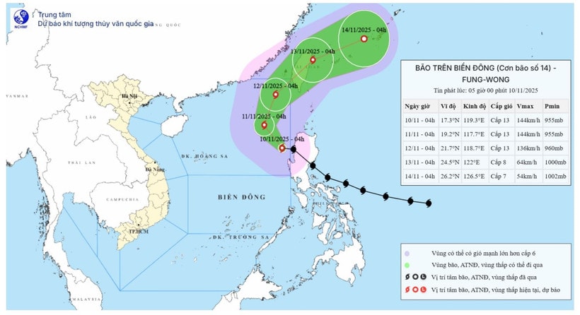
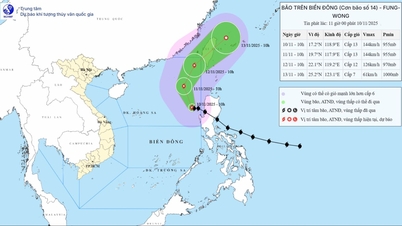
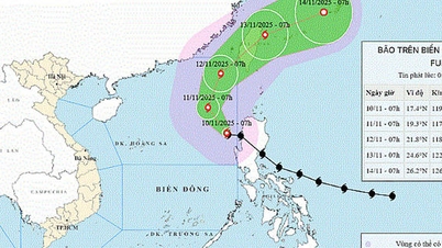
According to the National Center for Hydro-Meteorological Forecasting, at 4:00 a.m. this morning (November 10), the eye of the storm was located at about 17.3 degrees north latitude; 119.3 degrees east longitude, in the sea area east of the northern East Sea. The strongest wind near the eye of the storm was level 13 (134-149 km/h), gusting to level 16. Moving west-northwest, at a speed of about 25 km/h.
By 4 a.m. tomorrow (November 11), the storm will move northwest at a speed of 10-15 km/hour. The center of the storm will be at about 19.2 degrees north latitude; 117.7 degrees east longitude in the eastern sea area of the northern East Sea. The strongest wind near the center of the storm will be at level 13, gusting to level 16. Natural disaster risk: Level 3 in the eastern sea area of the northern East Sea.
As of 4 a.m. on November 12, the storm was moving northeast at a speed of 10-15 km/h. The center of the storm was at about 21.7 degrees north latitude; 118.7 degrees east longitude, in the northeastern sea, the northern East Sea. The strongest wind near the center of the storm was level 13, gusting to level 16. Natural disaster risk: Level 3 in the eastern sea of the northern East Sea.
At 4:00 a.m. on November 13, the storm moved northeast at a speed of 10-15 km/hour. The center of the storm was located at about 26.2 degrees north latitude; 126.5 degrees east longitude, on the northeastern coastal area of Taiwan island, then gradually weakened. The strongest wind near the center of the storm was level 8, gusting to level 10. Natural disaster risk: Level 3 in the eastern sea area of the northern East Sea.
From the next 72 to 96 hours, the storm will move in the east-northeast direction, traveling 20-25km per hour and continue to weaken.
The meteorological agency forecasts that the storm is unlikely to directly affect the Vietnamese mainland. However, at sea, the eastern sea area of the northern East Sea will have strong winds of level 8-10; near the eye of the storm will have strong winds of level 11-13, gusts of level 16, waves of 5-8m high, near the eye of the storm 8-10m. The sea will be very rough.
All boats operating in the above mentioned danger zones are susceptible to storms, whirlwinds, strong winds and large waves.
Source: https://baolamdong.vn/bao-fung-wong-da-di-vao-bien-dong-va-tro-thanh-con-bao-so-14-trong-nam-nay-401724.html


![Dong Nai OCOP transition: [Article 3] Linking tourism with OCOP product consumption](https://vphoto.vietnam.vn/thumb/402x226/vietnam/resource/IMAGE/2025/11/10/1762739199309_1324-2740-7_n-162543_981.jpeg)


Comment (0)