
 |
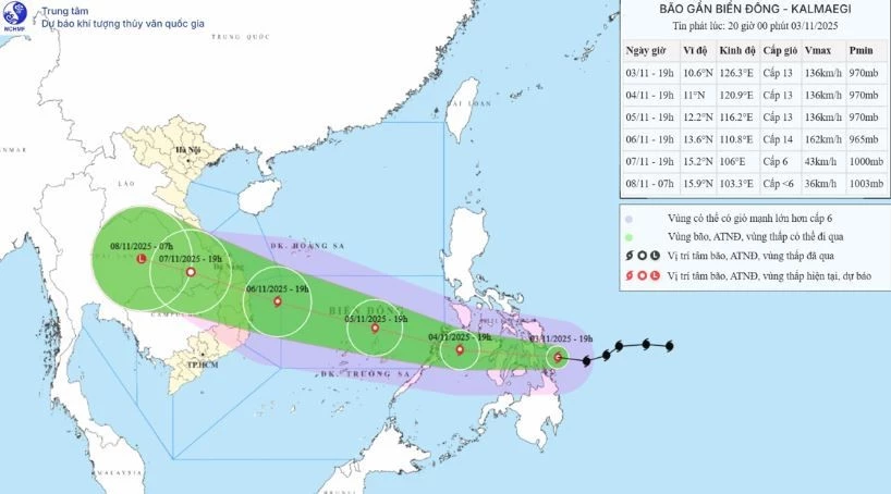
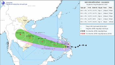
| Location and direction of the storm. (Source: National Center for Hydro-Meteorological Forecasting) |
Commenting on the storm situation, Director of the Department of Hydrometeorology Nguyen Thuong Hien said the storm moves quickly and is very strong, and will enter the East Sea around November 5.
At 7:00 p.m. on November 3, the center of the storm was located at about 10.6 degrees North latitude; 126.3 degrees East longitude, on the eastern coastal area of the central Philippines. The strongest wind near the center of the storm was level 12-13 (118-149 km/h), gusting to level 16. Moving west at a fast speed of about 25 km/h.
As of 7 p.m. on November 4, the storm was in the central Philippines with winds of level 13, gusts of level 16, moving mainly west at a speed of about 25 km/h. The affected area is the sea area east of the central part of the East Sea. Disaster risk level 3.
Then, at 7:00 p.m. on November 5, the storm was in the middle of the East Sea, about 800km east-southeast of the coast of Gia Lai province with strong winds of level 13, gusts of level 16, moving mainly in the West-Northwest direction at a speed of about 20-25km/h, moving into the East Sea. The affected area is the middle of the East Sea. Natural disaster risk level 3.
At 7:00 p.m. on November 6, the storm will move from Quang Ngai to Dak Lak, about 200km east-southeast of Gia Lai province, with winds of level 14, gusts of level 17, moving in the West-Northwest direction at a speed of about 25 km/h and likely to intensify. The affected area is the central East Sea (including Truong Sa special zone), the sea area from Da Nang to Khanh Hoa. Disaster risk level 4.
From the next 72 to 108 hours, the storm will move mainly in the West Northwest direction, about 20-25km per hour, with stable intensity, then gradually weakening.
Due to the impact of the storm, from around the afternoon of November 4, the sea area east of the central East Sea will have winds gradually increasing to level 6-7, then increasing to level 8-9; the area near the storm center will have strong winds of level 11-13, gusting to level 15-16, waves 5-7m high, and rough seas.
Warning: Around November 5-6, the central East Sea area (including Truong Sa special zone), the sea off the coast of Da Nang - Khanh Hoa area is likely to be affected by strong winds of level 12-14, gusts above level 17, waves 8-10m high, and rough seas.
All ships and structures operating in the above-mentioned dangerous area are strongly affected by storms, whirlwinds, strong winds and big waves.
Providing more information about this storm, Director Nguyen Thuong Hien said that the storm is likely to cause thunderstorms and tornadoes before the storm; widespread heavy rain from the night of November 6 to November 9 in the area from Quang Tri to Dak Lak. There is a risk of new flooding on rivers from Quang Tri to Khanh Hoa provinces.
"The current monitoring and forecast data still has a certain degree of uncertainty regarding the trajectory, intensity, direction of movement, rain center area and rainfall amount that is likely to fluctuate in the coming days. We respectfully request that ministries, branches and localities continue to closely monitor forecast and warning bulletins," Director Nguyen Thuong Hien noted.
Emphasizing the flood situation, Director Nguyen Thuong Hien suggested that the current flood on rivers in the Central region is at a high level, widespread flooding is occurring in many localities. Therefore, it is recommended that ministries and provincial People's Committees direct specialized agencies to direct reservoir management and operation units to closely monitor the hydrometeorological situation, implement monitoring and forecasting regimes, provide information, data and reporting regimes according to regulations to the Department of Hydrometeorology to serve forecasting and warning work.
According to VNA/Vietnam+
Source: https://baoquangtri.vn/xa-hoi/202511/bao-kalmaegi-di-chuyen-nhanh-du-kien-511-di-vao-bien-dong-2027a12/
![[Photo] Ho Chi Minh City Youth Take Action for a Cleaner Environment](https://vphoto.vietnam.vn/thumb/1200x675/vietnam/resource/IMAGE/2025/11/04/1762233574890_550816358-1108586934787014-6430522970717297480-n-1-jpg.webp)
![[Photo] Ca Mau "struggling" to cope with the highest tide of the year, forecast to exceed alert level 3](https://vphoto.vietnam.vn/thumb/1200x675/vietnam/resource/IMAGE/2025/11/04/1762235371445_ndo_br_trieu-cuong-2-6486-jpg.webp)

![[Photo] Panorama of the Patriotic Emulation Congress of Nhan Dan Newspaper for the period 2025-2030](https://vphoto.vietnam.vn/thumb/1200x675/vietnam/resource/IMAGE/2025/11/04/1762252775462_ndo_br_dhthiduayeuncbaond-6125-jpg.webp)

![[Photo] The road connecting Dong Nai with Ho Chi Minh City is still unfinished after 5 years of construction.](https://vphoto.vietnam.vn/thumb/1200x675/vietnam/resource/IMAGE/2025/11/04/1762241675985_ndo_br_dji-20251104104418-0635-d-resize-1295-jpg.webp)


Comment (0)