
Storm Kalmaegi is moving fast and very strong. When it makes landfall, it may cause strong winds of level 10-12, gusting to level 14-15. This is accompanied by widespread heavy rain in the area from Quang Tri to Dak Lak and the risk of flooding.
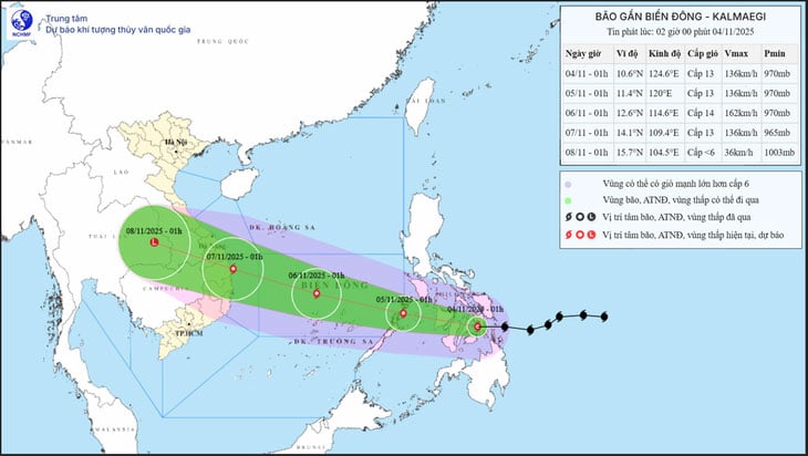 |
| Forecast of location and direction of storm Kalmaegi at 1am on November 4 - Photo: NCHMF |
According to the National Center for Hydro-Meteorological Forecasting at 1:00 a.m. on November 4, the center of storm Kalmaegi was sweeping through the central region of the Philippines, with the strongest wind near the center of the storm reaching level 13 (134-149 km/h), gusting to level 16.
It is forecasted that around dawn tomorrow (November 5), the storm will enter the East Sea and become storm number 13 in 2025.
The meteorological agency said the latest forecast results show the storm is moving fast and very strong.
The storm is forecast to reach level 13-14 intensity (134-166km/h), gusting to level 17 when it passes through the Truong Sa special economic zone and the Da Nang - Khanh Hoa sea area.
"From the night of November 6, the storm is likely to directly affect the area from Da Nang to Khanh Hoa .
The strongest wind in coastal areas (including Ly Son and Quang Ngai special zones) is likely to reach level 12-13, gusting over level 15. Inland coastal areas are likely to reach level 10-12, gusting to level 14-15.
The meteorological agency also warned that Typhoon Kalmaegi is a strong storm, capable of causing thunderstorms and tornadoes before the storm.
The meteorological agency noted that monitoring and forecasting data still have a certain degree of uncertainty regarding the trajectory, intensity, direction of movement, rain center area and rainfall amount that is likely to fluctuate in the coming days, so authorities at all levels and people should continue to closely monitor the next forecasts and warnings.
In the immediate future, from around this afternoon, in the eastern sea area of the central East Sea, the wind will gradually increase to level 6-7, then increase to level 8/11, near the storm center it will be level 11-13, gusting to level 15-16, with waves 5-7m high.
During November 5 and 6, the central East Sea area (including Truong Sa special zone), the sea off the coast of Da Nang - Khanh Hoa area is likely to be affected by strong winds of level 12-14, gusting above level 17, and waves 8-10m high.
All ships and structures operating in the above-mentioned dangerous areas are strongly affected by storms, whirlwinds, strong winds and big waves.
According to Chi Tue/tuoitre.vn
Source: https://baovinhlong.com.vn/thoi-su/202511/bao-kalmaegi-sang-nay-di-nhanh-cuong-do-rat-manh-e68066c/
![[Photo] Ca Mau "struggling" to cope with the highest tide of the year, forecast to exceed alert level 3](https://vphoto.vietnam.vn/thumb/1200x675/vietnam/resource/IMAGE/2025/11/04/1762235371445_ndo_br_trieu-cuong-2-6486-jpg.webp)
![[Photo] Panorama of the Patriotic Emulation Congress of Nhan Dan Newspaper for the period 2025-2030](https://vphoto.vietnam.vn/thumb/1200x675/vietnam/resource/IMAGE/2025/11/04/1762252775462_ndo_br_dhthiduayeuncbaond-6125-jpg.webp)


![[Photo] The road connecting Dong Nai with Ho Chi Minh City is still unfinished after 5 years of construction.](https://vphoto.vietnam.vn/thumb/1200x675/vietnam/resource/IMAGE/2025/11/04/1762241675985_ndo_br_dji-20251104104418-0635-d-resize-1295-jpg.webp)
![[Photo] Ho Chi Minh City Youth Take Action for a Cleaner Environment](https://vphoto.vietnam.vn/thumb/1200x675/vietnam/resource/IMAGE/2025/11/04/1762233574890_550816358-1108586934787014-6430522970717297480-n-1-jpg.webp)


Comment (0)