
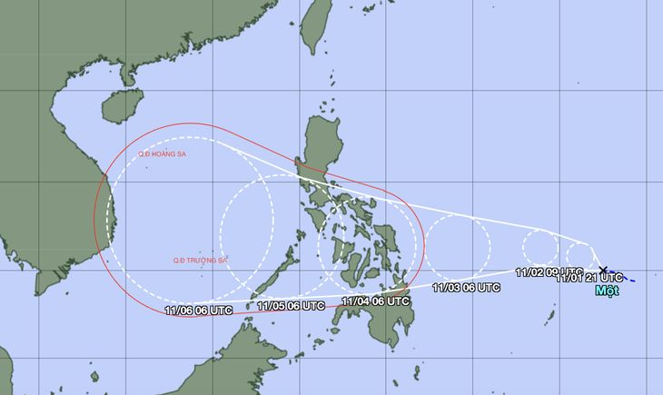
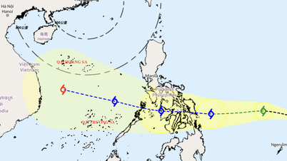
Forecast of location and direction of tropical depression - Photo: JMA
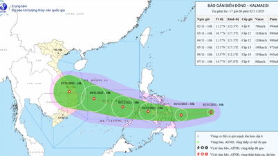
According to the National Center for Hydro-Meteorological Forecasting on November 1, there is an active tropical depression in the eastern region of the Philippines.
According to current forecast data, between tonight and tomorrow morning (November 2), the tropical depression is likely to strengthen into a storm.
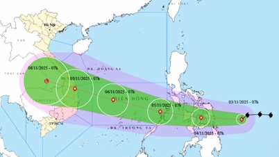
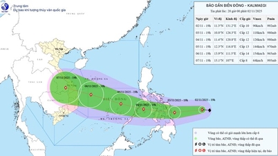
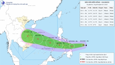
Around November 5 (Wednesday), the storm will enter the East Sea and become storm number 13.
"This is forecast to be a strong storm in the East Sea, the strongest in the Truong Sa special economic zone, it could be over level 12.
Around November 7, the storm will move into our country's mainland, the focus area that needs to be noted and likely to be directly impacted is from Da Nang City to Khanh Hoa.
The storm may cause strong winds and heavy rain in the provinces of the Central Central, South Central and Central Highlands regions from the night of November 6 to 9," the National Center for Hydro-Meteorological Forecasting initially said.
The meteorological agency noted that the storm has not yet formed and is still affected by many large-scale factors in the coming days as well as the impact of terrain when it makes landfall in the Philippines, so scenarios regarding the intensity, direction of movement as well as areas directly affected by storm No. 13 still need to be monitored and updated with new observation and forecast data.
Also according to the National Center for Hydro-Meteorological Forecasting, due to the influence of the tropical convergence zone with an axis at about 10-13 degrees North latitude connecting with the low pressure area in the south of Hoang Sa archipelago, in the sea area from south of Quang Tri to Quang Ngai , the Gulf of Thailand, the sea area south of the northern East Sea (including Hoang Sa special zone), the central East Sea area has scattered showers and thunderstorms. In the Gulf of Tonkin, there are strong northeast winds of level 5, sometimes level 6, gusting to level 7.
Forecast, tonight and tomorrow in the northern East Sea area (including Hoang Sa special zone) there will be wind level 6, from tomorrow afternoon there will be wind level 7, gusting to level 8-9.
In the Gulf of Tonkin, the wind is level 5, sometimes level 6, from tomorrow afternoon it will gradually strengthen to level 6, gusting to level 7-8, with waves 1.5 - 3m high.
In the sea area from southern Quang Tri to Quang Ngai, the wind is level 5, sometimes level 6, gusting to level 7-8.
In addition, tonight and tomorrow, in the southern area of the Gulf of Tonkin, the sea area from Quang Tri to Ca Mau, from Ca Mau to An Giang, the Gulf of Thailand, the northern and central areas of the East Sea (including Hoang Sa special zone), there will be scattered showers and thunderstorms.
During thunderstorms there is a possibility of tornadoes, strong gusts of wind level 6-7 and waves over 2m high.
On the night of November 2 and 3, the northern East Sea area (including Hoang Sa special zone) will have strong northeast winds of level 6-7, gusting to level 8-9, rough seas, and waves 3-5m high.
In the Gulf of Tonkin, there are strong northeast winds of level 6, sometimes level 7, gusting to level 8, rough seas, waves 2 - 3.5m high.
The sea area from southern Quang Tri to Quang Ngai has strong northeast winds of level 5, sometimes level 6, gusting to level 7-8, rough seas, waves 2-3m high.
All vessels operating in the above areas are at high risk of being affected by strong winds and large waves.
Source: https://tuoitre.vn/bao-sap-hinh-thanh-ngoai-khoi-philippines-kha-nang-vao-bien-dong-thanh-con-bao-so-13-20251101174758508.htm


![[Photo] President Luong Cuong receives US Secretary of War Pete Hegseth](https://vphoto.vietnam.vn/thumb/1200x675/vietnam/resource/IMAGE/2025/11/02/1762089839868_ndo_br_1-jpg.webp)

![[Photo] Lam Dong: Images of damage after a suspected lake burst in Tuy Phong](https://vphoto.vietnam.vn/thumb/1200x675/vietnam/resource/IMAGE/2025/11/02/1762078736805_8e7f5424f473782d2162-5118-jpg.webp)


Comment (0)