
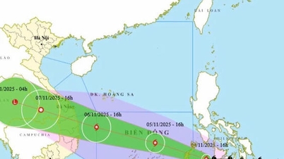
According to information from the Japan Meteorological Agency and the Joint Typhoon Warning Center (JTWC - USA), the tropical depression in the East of the Philippines has strengthened into storm Kalmaegi.
JTWC said that at 4:00 p.m. on November 2 (Vietnam time), storm Kalmaegi was about 1,382 km southeast of Manila (Philippines), moving northwest at a speed of 30 km/hour.
At 5:00 p.m. on November 2, the Vietnam National Center for Hydro-Meteorological Forecasting officially issued a warning about this storm.
According to the Vietnam Meteorological Agency, the eye of the storm this afternoon was at approximately 11.2 degrees North latitude - 132.5 degrees East longitude. The strongest wind near the eye of the storm is level 9 (75-88 km/h), gusting to level 11.

The National Center for Hydro-Meteorological Forecasting said that by the afternoon of November 3, the storm's center will be located in the sea east of the central Philippines, moving mainly westward at a speed of about 20km/hour, with an intensity of level 11-12, gusting to level 15.
At 4:00 p.m. on November 4, the storm passed through the central Philippines in a West-Northwest direction at a speed of about 20-25 km/hour, with a strong intensity of level 12, gusting to level 15, and the dangerous sea area being in the East of the central East Sea.
On November 5, the center of storm Kalmaegi entered the East Sea, becoming storm number 13. By 4:00 p.m. on November 5, the center of the storm was located in the middle of the East Sea, moving steadily in the West-Northwest direction at a speed of about 15km/hour but with the potential to strengthen to level 13, gusting to level 16-17, the dangerous area at this time is from latitude 10 to 15 and east of longitude 115 (including Truong Sa special zone).
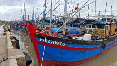
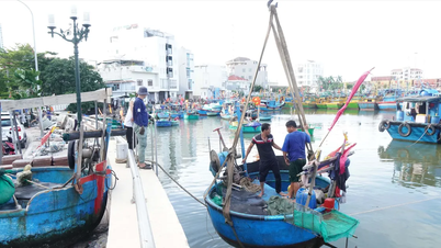
According to the preliminary assessment of the meteorological agency, from November 5 to 6, the central area of the East Sea, including the Truong Sa special zone, and the offshore waters from Da Nang to Khanh Hoa, will be affected by strong winds of level 12-14, gusting to level 17, and waves of 8-10m high.
The US JTWC also said that after making landfall in the Philippines, the storm will temporarily weaken and then quickly strengthen again when entering the East Sea, possibly reaching a maximum intensity of 195km/h (equivalent to level 12) in the East Sea and before making landfall in central Vietnam.
According to JTWC, currently, favorable factors for the storm to intensify include: very high sea surface temperatures, large ocean heat content and strong upper-level wind currents. When passing through Vietnam's terrain and into southern Laos, the storm will weaken rapidly due to interaction with the terrain.
Source: https://www.sggp.org.vn/bao-kalmaegi-dang-tien-gan-bien-dong-post821369.html

![[Photo] The road connecting Dong Nai with Ho Chi Minh City is still unfinished after 5 years of construction.](https://vphoto.vietnam.vn/thumb/1200x675/vietnam/resource/IMAGE/2025/11/04/1762241675985_ndo_br_dji-20251104104418-0635-d-resize-1295-jpg.webp)

![[Photo] Panorama of the Patriotic Emulation Congress of Nhan Dan Newspaper for the period 2025-2030](https://vphoto.vietnam.vn/thumb/1200x675/vietnam/resource/IMAGE/2025/11/04/1762252775462_ndo_br_dhthiduayeuncbaond-6125-jpg.webp)
![[Photo] Ca Mau "struggling" to cope with the highest tide of the year, forecast to exceed alert level 3](https://vphoto.vietnam.vn/thumb/1200x675/vietnam/resource/IMAGE/2025/11/04/1762235371445_ndo_br_trieu-cuong-2-6486-jpg.webp)
![[Photo] Ho Chi Minh City Youth Take Action for a Cleaner Environment](https://vphoto.vietnam.vn/thumb/1200x675/vietnam/resource/IMAGE/2025/11/04/1762233574890_550816358-1108586934787014-6430522970717297480-n-1-jpg.webp)


Comment (0)