
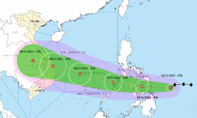
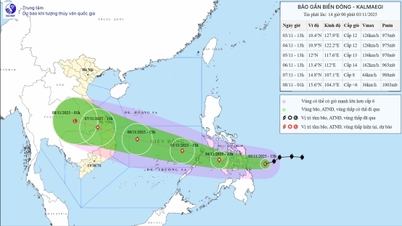
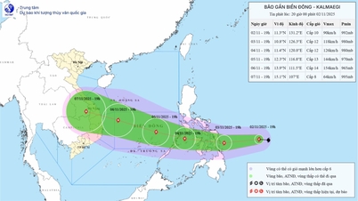
The National Center for Hydro-Meteorological Forecasting said that at 7:00 a.m. today, the center of the storm was in the sea east of the central Philippines, with the strongest wind speed of 102 km/h, level 12, gusting to level 15, and moving west-southwest at a speed of about 25 km/h.
Forecast at 7am tomorrow, November 4, the storm in the central Philippines, the strongest wind is level 12, gusts level 15, mainly in the west direction, speed reduced to 20 km/h. The storm then enters the East Sea, receiving more energy from the warm sea area to increase in strength. By 7am on November 5, the storm center is in the east of the middle of the East Sea, increasing to level 13, gusts level 15 and slightly tilted north with a speed of 20-25 km/h.
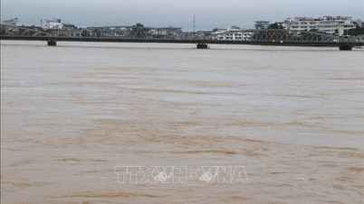
At 7:00 a.m. on October 6, in the middle of the East Sea, about 430 km from the coast of Gia Lai , the storm was at its strongest level 14, gusting to level 17, keeping its direction at a speed of 20 km/h.
The Japan Meteorological Agency said the storm's current wind speed is about 108 km/h, before entering the Philippines it will increase to 126 km/h, and in the East Sea it can reach 144 km/h. Hong Kong Radio said that in the middle of the East Sea the storm will be strong at 165 km/h, and when approaching the Gia Lai mainland it can reach 175 km/h. The US Navy also said that the storm will increase in strength as it approaches the mainland, and the wind speed when it makes landfall can reach 185 km/h.
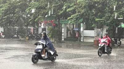
Impact of the storm, from tomorrow afternoon the eastern sea of the middle of the East Sea will gradually increase in strength from level 6 to 12, gusting to level 14-15, waves 5-7 m high. On November 5-6, when the storm enters the middle of the East Sea, off the coast of Da Nang - Khanh Hoa, the wind will increase to level 12-14, gusting to level 17, waves 8-10 m high. All ships and structures operating in this dangerous area are likely to be affected.
PVSource: https://baohaiphong.vn/bao-kalmaegi-tang-ba-cap-ngay-5-11-vao-bien-dong-525432.html
![[Photo] Lam Dong: Close-up of illegal lake with broken wall](https://vphoto.vietnam.vn/thumb/1200x675/vietnam/resource/IMAGE/2025/11/03/1762166057849_a5018a8dcbd5478b1ec4-jpg.webp)
![[Photo] Prime Minister Pham Minh Chinh receives the Chairman of the Japan-Vietnam Friendship Association in the Kansai region](https://vphoto.vietnam.vn/thumb/1200x675/vietnam/resource/IMAGE/2025/11/03/1762176259003_ndo_br_dsc-9224-jpg.webp)
![[Photo] Fall Fair 2025 and impressive records](https://vphoto.vietnam.vn/thumb/1200x675/vietnam/resource/IMAGE/2025/11/03/1762180761230_ndo_br_tk-hcmt-15-jpg.webp)

![[Photo] General Secretary To Lam receives Singaporean Ambassador Jaya Ratnam](https://vphoto.vietnam.vn/thumb/1200x675/vietnam/resource/IMAGE/2025/11/03/1762171461424_a1-bnd-5309-9100-jpg.webp)


Comment (0)