
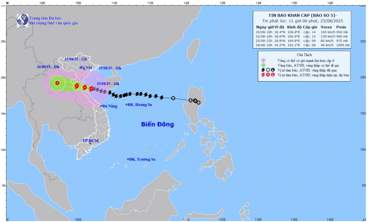
Forecast map of storm No. 5's trajectory and intensity at 11:00 a.m. on August 25, 2025.
Director of the National Center for Hydro-Meteorological Forecasting, Mr. Mai Van Khiem, assessed that as of 2:00 p.m. on August 25, the center of the storm was at about 18.6 degrees North latitude; 105.9 degrees East longitude, on the coast of Thanh Hoa to Ha Tinh provinces. The strongest wind near the center of the storm is level 12 - 13 (134 - 166 km/h), gusting to level 15; moving in the West Northwest direction at a speed of 15 - 20 km/h.
Forecast by 10pm on August 25, the center of the storm is at about 18.8 degrees North latitude; 104.8 degrees East longitude, on the mainland from Thanh Hoa to Ha Tinh provinces. The strongest wind near the center of the storm is level 9, gusting to level 12; moving in the West Northwest direction at a speed of 15 - 20 km/h towards the Central Laos region, then gradually weakening into a tropical depression.
Due to the influence of storm No. 5, from the morning of August 25, the sea area from Thanh Hoa to Quang Tri (including Hon Ngu island, Con Co special zone) has strong winds of level 8 - 11, near the storm's eye level 12 - 14, gusting to level 17; waves 5 - 7 m high, near the storm's eye 8 - 10 m; rough seas. The northern Gulf of Tonkin (including the special zones: Cat Hai, Co To, Van Don) has strong winds of level 6 - 7, gusting to level 9; especially the southern area of the northern Gulf of Tonkin (including Bach Long Vi special zone) has strong winds of level 8 - 9, gusting to level 11; waves 3 - 5 m high; rough seas.
Coastal areas and islands from Hai Phong to the north of Ha Tinh have storm surges of 0.5 - 1.8 m, and 1 - 1.8 m in Thanh Hoa and Nghe An. Water levels at Hon Dau (Hai Phong) are 3.5 - 4 m, Ba Lat (Ninh Binh) is 1.8 - 2.3 m, Sam Son (Thanh Hoa) is 3.7 - 4.2 m, Hon Ngu (Nghe An) is 3.5 - 4 m, and Cua Nhuong (Ha Tinh) is 2.2 - 2.6 m. There is a high risk of flooding along dykes, coastal roads, and river mouths, especially along the coast of Nghe An and Thanh Hoa in the afternoon and evening of August 25.
Mr. Mai Van Khiem warned that the weather at sea and in coastal areas during the storm is extremely dangerous, unsafe for any vehicle or structure operating in the danger zone such as: tourist boats, passenger ships, transport ships, cages, rafts, aquaculture areas, dykes, embankments, coastal routes. Vehicles are highly likely to be capsized, destroyed; flooded due to strong winds, big waves and rising sea levels.
On land, from the morning of August 25, the northern Thanh Hoa area will have strong winds of level 8 - 9, gusts of level 10 - 11; the southern Thanh Hoa - northern Ha Tinh area will have strong winds of level 10 - 11, the area near the storm center will have winds of level 12 - 13, gusts of level 15 - 16; the southern Ha Tinh, Quang Tri areas, coastal areas of provinces from Quang Ninh to Ninh Binh will have strong winds of level 6 - 8, gusts of level 9 - 10.
From noon on August 25 to the end of August 26, in the midlands and deltas of the North, Lao Cai, Son La and from Thanh Hoa to Quang Tri, there will be widespread heavy rain with common rainfall of 100 - 150 mm, locally over 250 mm; in the area from Thanh Hoa to Northern Quang Tri, there will be heavy to very heavy rain with common rainfall of 200 - 400 mm, locally over 600 mm.
From noon on August 25 to 26, the capital Hanoi will have moderate rain, heavy rain and thunderstorms. On August 25, Da Nang will have rain, moderate rain and thunderstorms. From noon on August 25 to 26, Ho Chi Minh City will have rain, showers and thunderstorms (thunderstorms concentrated in the afternoon and evening). During thunderstorms, be on guard against the risk of tornadoes and strong gusts of wind.
Source baotintuc.vn
Source: https://baophutho.vn/bao-so-5-tien-sat-dat-lien-gio-giat-cap-16-nguy-hiem-238506.htm


![[Photo] Cat Ba - Green island paradise](/_next/image?url=https%3A%2F%2Fvphoto.vietnam.vn%2Fthumb%2F1200x675%2Fvietnam%2Fresource%2FIMAGE%2F2025%2F12%2F04%2F1764821844074_ndo_br_1-dcbthienduongxanh638-jpg.webp&w=3840&q=75)


Comment (0)