
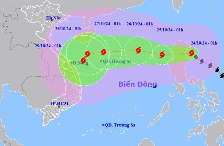
The National Center for Hydro-Meteorological Forecasting said that at 1:00 a.m. on October 24, storm Trami (in Vietnamese, Tra Mi) was on the mainland east of Luzon Island (Philippines). The strongest wind near the storm center was level 9-10 (75-102 km/h), gusting to level 12. The storm moved in a West-Northwest direction at a speed of 15-20 km/h.
It is forecasted that in the next 24 hours, the storm will change direction, move westward at a speed of about 15km/h and enter the East Sea, becoming the 6th storm of the year. The center of the storm is located in the eastern sea of the North East Sea. The strongest wind near the center of the storm is level 9, gusting to level 11.
Today, October 24, storm Trami will enter the East Sea. (Source: NCHMF)
At about 1am on October 26, storm No. 6 was 510km east of Hoang Sa archipelago, its direction of movement continued to change, moving west-northwest, traveling 10-15km per hour. The strongest wind near the storm's center was level 10, gusting to level 12.
At 1am on October 27, the storm was in the sea north of the Hoang Sa archipelago and changed direction, moving west at a speed of 15-20km/h. The strongest wind near the storm's center was level 11-12, gusting to level 15.
From the next 72 to 120 hours, the storm will move mainly in a westerly direction, traveling 10-15km per hour, then likely change direction to the southwest and move more slowly.
At sea, on the day and night of October 24, the eastern sea of the North East Sea will have strong winds of level 6-7, near the eye of the storm will have winds of level 8-9, gusting to level 11. From noon to afternoon of the same day, the winds will increase to level 8, near the eye of the storm will have winds of level 9-10, gusting to level 12, the sea will be very rough, waves will be 3-5m high, near the eye of the storm will be 57m.
The western sea area of the North East Sea (including the sea area of Hoang Sa archipelago) has strong winds of level 6, sometimes level 7, gusts of level 8-9, rough seas, waves 3-5m high.
In the central East Sea, the wind is strong at level 6, in which the eastern sea has strong wind at level 7, gusting at level 8-9, rough seas, waves 3-5 high.
The sea area from Quang Tri to Binh Thuan has strong winds of level 6, gusts of level 7-8, rough seas, waves 2-3.5m high. The sea area to the east of the South China Sea has strong winds of level 5, sometimes level 6, gusts of level 7-8, rough seas, waves 2-3m high.
In addition, on the day and night of October 24, the eastern sea of the North East Sea will have storms, the central and southern East Sea (including the waters of the Truong Sa archipelago), the sea from Binh Thuan to Ca Mau, Ca Mau to Kien Giang and the Gulf of Thailand will have scattered showers and thunderstorms. During thunderstorms, tornadoes and strong gusts of wind of level 7-8.3 may occur.
The meteorological agency warned that on the day and night of October 25, the North East Sea area (including the waters of Hoang Sa archipelago) will have strong winds of level 7-8, near the storm's eye level 9-10, gusts of level 12, waves 3-5m high, near the storm's eye 5-7m, very rough seas.
The northern sea area in the central East Sea has strong winds of level 6, sometimes level 7, gusting to level 8-9, rough seas, waves 3-5m high.
The sea area from Quang Tri to Khanh Hoa has strong northwest wind level 6, gusting to level 7-8, rough sea, waves 2-4.5m high.

![[Photo] The captivating scenery of the fragrant maple forest in Quang Tri](/_next/image?url=https%3A%2F%2Fvphoto.vietnam.vn%2Fthumb%2F1200x675%2Fvietnam%2Fresource%2FIMAGE%2F2025%2F12%2F10%2F1765353233198_lan09046-jpg.webp&w=3840&q=75)
![[Photo] Explore the US Navy's USS Robert Smalls warship](/_next/image?url=https%3A%2F%2Fvphoto.vietnam.vn%2Fthumb%2F1200x675%2Fvietnam%2Fresource%2FIMAGE%2F2025%2F12%2F10%2F1765341533272_11212121-8303-jpg.webp&w=3840&q=75)


![[Video] The craft of making Dong Ho folk paintings has been inscribed by UNESCO on the List of Crafts in Need of Urgent Safeguarding.](https://vphoto.vietnam.vn/thumb/402x226/vietnam/resource/IMAGE/2025/12/10/1765350246533_tranh-dong-ho-734-jpg.webp)


Comment (0)