

Flood warning due to high tide in Cai Lon riverside area.
Over the past two days, water levels at most coastal stations in An Giang have tended to rise rapidly due to the tide and the impact of rising water (from 20 - 30cm).
The highest water level actually measured at 7:00 a.m. on December 7 is as follows: In coastal areas, at Xeo Ro tidal forecasting station, the highest water level is 1.18 m, 0.18 m above alert level 3; at Rach Gia station, 0.92 m, about 0.02 m above alert level 3; at Ha Tien station, 1.3 m.
The An Giang sea area is forecasted to have northeast winds of level 3 - 4, sometimes level 5. The tide in the coastal area of An Giang tends to decrease slowly but will remain at a high level in the next 1 to 2 days, due to the influence of rising water (from 10 - 20cm), then decrease rapidly. The highest peak tide of the day occurs from 5 to 8 am.
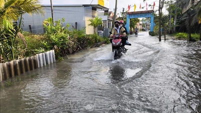
Flooded area: Riverbanks of Cai Lon and Cai Be, especially Vinh Hoa Hung commune; Can Gao canal, section through Tay Yen commune; riverside roads in Ha Tien ward and To Chau ward; coastal communes from Van Khanh to Ha Tien... Flooding time in the morning is from 4:30 am to 8 am, maximum flood depth is 20 - 60 cm, in some places over 60 cm.
Flood risk warning level 2. Flooding caused by high tides affects constructions, aquaculture, agricultural production and causes difficulties in transportation.
News and photos: THUY TRANG
Source: https://baoangiang.com.vn/canh-bao-ngap-lut-do-trieu-cuong-tai-khu-vuc-ven-song-cai-lon-cai-be-a469617.html


Comment (0)