
Latest storm update: At 10:00 AM (November 8th), the center of Typhoon Yinxing (Typhoon No. 7) was located at approximately 18.3 degrees North latitude and 118.9 degrees East longitude, in the eastern part of the North East Sea.
The trajectory of Typhoon Yinxing (Typhoon No. 7)
At 10:00 AM (November 8th), the center of Typhoon Yinxing (Typhoon No. 7) was located at approximately 18.3 degrees North latitude and 118.9 degrees East longitude, in the eastern part of the North East Sea. The strongest winds near the center of the typhoon were at level 13-14 (134-166 km/h), with gusts up to level 17. It was moving in a west-southwest direction at a speed of approximately 15 km/h.
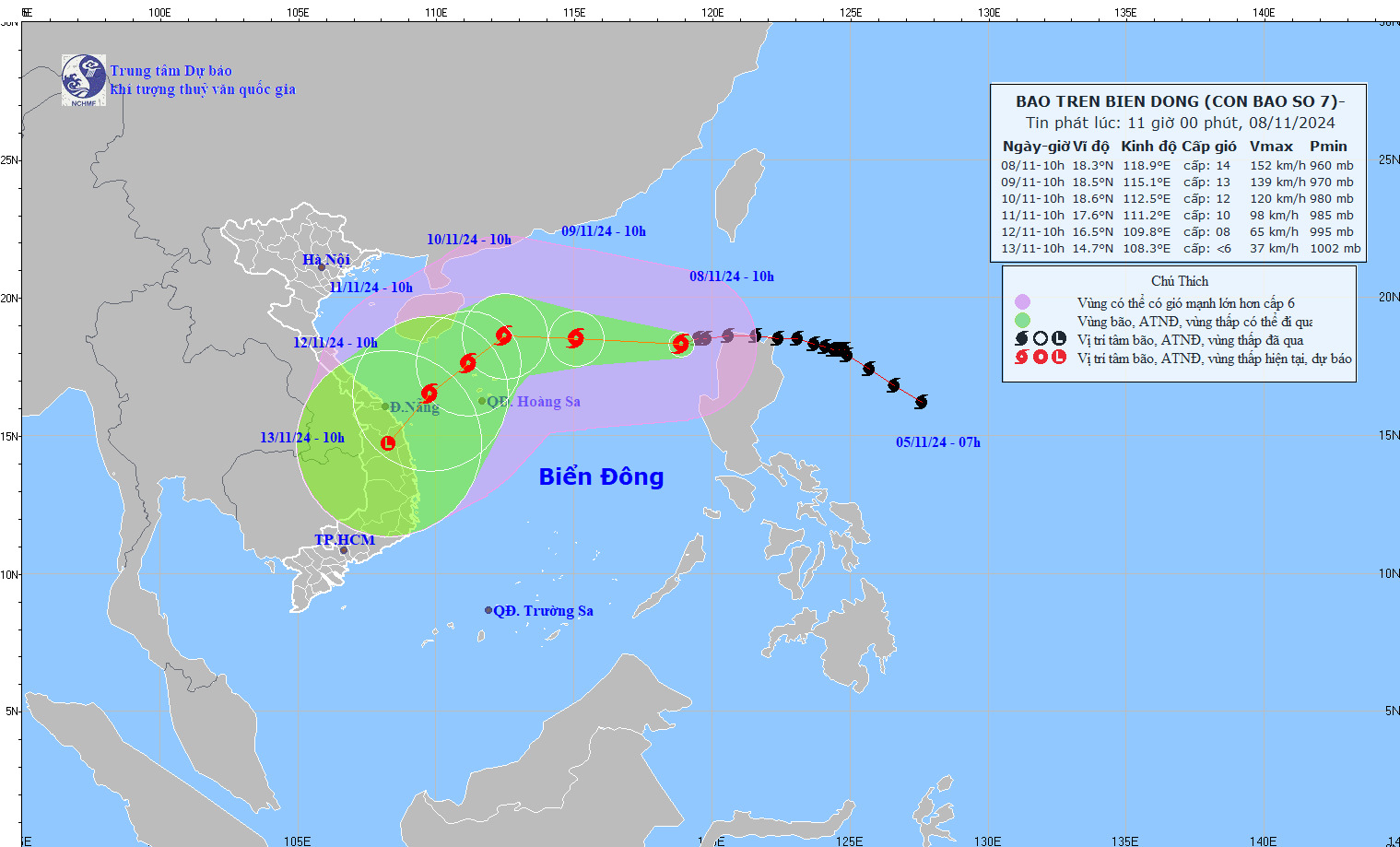
Latest storm news: The latest forecast on the trajectory of Typhoon Yinxing (Typhoon No. 7). Photo: NCHMF
Forecast of the development of Typhoon Yinxing (Typhoon No. 7) over the next 24 to 72 hours.
Forecast time | Direction, speed | Location | Intensity | Hazardous area | Level of natural disaster risk (Affected area) |
10:00 AM, 09/11 | West-Northwest, 15-20km/h | 18.5N-115.1E; in the northern South China Sea, approximately 430km northeast of the Paracel Islands. | Level 12-13, gusts up to level 16. | Latitude 16.0N-21.0N; East of longitude 113.5E | High school: the northern South China Sea region (including the waters around the Paracel Islands); specifically the eastern part. level 4 |
10:00 AM on 10/11 | West-northwest, approximately 10 km/h, gradually weakening. | 18.6N-112.5E; approximately 270km north-northeast of the Paracel Islands. | Level 12, then level 15 | Latitude 16.0N-21.5N; Longitude 111.0E-116.5E | High school: Northern South China Sea region (including the waters around the Paracel Islands) |
10:00 AM on November 11th | Southwest, 5-10 km/h, further weakening | 17.6N-111.2E; approximately 140km north-northwest of the Paracel Islands. | Level 10, then level 13 | Latitude 16.0N-21.0N; Longitude 109.0E-115.5E | High school: Northern South China Sea region (including the waters around the Paracel Islands) |
Over the next 72 to 120 hours, the storm will move southwest at a speed of 10-15 km per hour, continuing to weaken in intensity.
Regarding the impact of Typhoon Yinxing (Typhoon No. 7)
The National Center for Meteorological and Hydrological Forecasting warns of strong winds and high waves due to the influence of the storm.
In the eastern part of the North East Sea, winds are strong, reaching levels 8-11, with winds near the storm's center reaching levels 12-14, gusting to level 17. Sea waves are 4.0-6.0m high, and 6.0-8.0m near the storm's center; the sea is extremely rough.
Vessels operating in the aforementioned hazardous areas are susceptible to the effects of thunderstorms, tornadoes, strong winds, and high waves.
Given the situation, tourists planning to visit the South Central coastal areas in the near future should be prepared for the complex developments of Typhoon Yinxing (Typhoon No. 7).
Although the impact of the storm on land is not yet clear, one should not be complacent. It is necessary to continuously update weather information and consider adjusting the itinerary to ensure personal safety and a fulfilling travel experience.
Source: https://danviet.vn/tin-bao-moi-nhat-cap-nhat-moi-nhat-ve-huong-di-chuyen-cua-bao-so-7-yinxing-2024110811341727.htm


![[Photo] Closing Ceremony of the 10th Session of the 15th National Assembly](/_next/image?url=https%3A%2F%2Fvphoto.vietnam.vn%2Fthumb%2F1200x675%2Fvietnam%2Fresource%2FIMAGE%2F2025%2F12%2F11%2F1765448959967_image-1437-jpg.webp&w=3840&q=75)
![[Photo] Prime Minister Pham Minh Chinh holds a phone call with the CEO of Russia's Rosatom Corporation.](/_next/image?url=https%3A%2F%2Fvphoto.vietnam.vn%2Fthumb%2F1200x675%2Fvietnam%2Fresource%2FIMAGE%2F2025%2F12%2F11%2F1765464552365_dsc-5295-jpg.webp&w=3840&q=75)


![[OFFICIAL] MISA GROUP ANNOUNCES ITS PIONEERING BRAND POSITIONING IN BUILDING AGENTIC AI FOR BUSINESSES, HOUSEHOLDS, AND THE GOVERNMENT](https://vphoto.vietnam.vn/thumb/402x226/vietnam/resource/IMAGE/2025/12/11/1765444754256_agentic-ai_postfb-scaled.png)


Comment (0)