
According to the Provincial Hydrometeorological Station, the highest daily peak water level on river banks and canals in the province is rising rapidly following the high tide of the 15th day of the 9th lunar month and is 5cm higher than alert level 1 (ISI) to 25cm higher than ISI III in the past 24 hours.
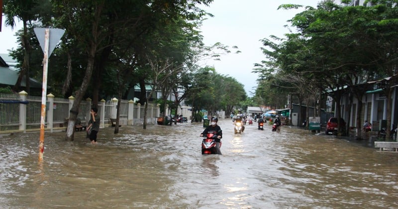 |
| High tides are likely to flood low-lying areas across the province. |
The highest peak water level at the stations during this high tide occurred on November 5-8 (September 16-19 in the lunar calendar). My Thuan station was 40cm higher than BĐ III, Cho Lach station was 18cm higher than BĐ III, Tra Vinh station was 20cm higher than BĐ III, the remaining stations were 5-12cm higher than BĐ III.
My Thuan and Cho Lach stations have peak times at 3-6am and 4-7:30pm on November 5-8.
The peak times at My Hoa, Tra Vinh and Cau Quan stations are from 2:30 a.m. to 5:00 a.m. and 3:30 p.m. to 6:30 p.m. on November 5-8.
An Thuan, Binh Dai and Ben Trai stations have peak times from 1:00 to 3:30 a.m. and from 2:20 to 5:30 p.m. on November 5-7.
Potential for flooding of low-lying areas across the province.
Flooding is likely to have a negative impact on the environment, road and waterway traffic activities, residential areas; fruit growing areas, livestock areas, aquaculture areas; especially the upstream areas of the province from Phu Tuc commune (Tien river), Tien Thuy commune - Vinh Thanh commune - Phuoc My Trung commune (Ham Luong river), Thanh Thoi commune - Nhi Long commune - Long Duc ward (Co Chien river), Tan Hoa commune (Hau river) and above; there is a possibility of deep flooding in areas along Tien river, Ham Luong river, Co Chien river, Mang Thit river, Hau river, areas outside the dike, some roads in Thanh Duc ward; Phuoc Hau ward, Long Chau ward...; other low-lying areas, weak dike areas - without and outside the dike, areas of sandbanks, islands, riverside areas, and coastal areas.
The possibility of flooding from November 4-10 is from 5-50cm, the deepest flooding depth appears from November 5-7 from 20-50cm, then gradually decreases (the flooding depth will gradually increase according to the rising water level of the tide).
Disaster risk warning level: Level 2.
Localities need to have plans to protect and reinforce the dike system, raise furniture and belongings, and proactively deal with flooding and landslides caused by high tides combined with upstream floods, rain and other factors.
News and photos: THAO LY
Source: https://baovinhlong.com.vn/thoi-su/202511/dinh-trieu-cuong-cao-nhat-xuat-hien-tu-ngay-5-811-4f83949/
![[Photo] The road connecting Dong Nai with Ho Chi Minh City is still unfinished after 5 years of construction.](https://vphoto.vietnam.vn/thumb/1200x675/vietnam/resource/IMAGE/2025/11/04/1762241675985_ndo_br_dji-20251104104418-0635-d-resize-1295-jpg.webp)
![[Photo] Opening of the 14th Conference of the 13th Party Central Committee](https://vphoto.vietnam.vn/thumb/1200x675/vietnam/resource/IMAGE/2025/11/05/1762310995216_a5-bnd-5742-5255-jpg.webp)


![[Photo] Panorama of the Patriotic Emulation Congress of Nhan Dan Newspaper for the period 2025-2030](https://vphoto.vietnam.vn/thumb/1200x675/vietnam/resource/IMAGE/2025/11/04/1762252775462_ndo_br_dhthiduayeuncbaond-6125-jpg.webp)


Comment (0)