

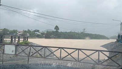
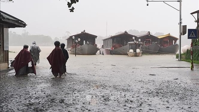
On the evening of October 26, flood levels on the two main rivers of Hue city, the Huong River, rose above alert level 2 with 0.71m, and the Bo River rose above alert level 2 with 0.60m.
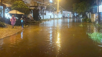
Heavy rain caused Dap Da and some streets on the southern bank of the Perfume River in the center of Hue city to be partially flooded, such as To Huu, Nguyen Huu Canh, and Duong Van An. The walking streets along the southern bank of the Perfume River were deeply flooded.
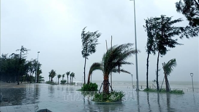
It is forecasted that from now until October 28, the city will continue to have heavy to very heavy rain, with total rainfall ranging from 250-500mm, and in some places over 700mm, causing floods on rivers to continue to rise; in which, the Bo River will rise to near alert level 3; the Huong River will continue to rise above alert level 2.
Authorities warn of the impact of floods, the risk of widespread and prolonged flooding in downstream rivers, low-lying areas, urban areas, flash floods and landslides on steep slopes in mountainous areas. Areas at high risk of flash floods, landslides and riverbank and coastal landslides are concentrated in communes and wards including: A Luoi, Nam Dong, Khe Tre, Long Quang, Ho Chi Minh road, Provincial Road 74, La Son - Tuy Loan Expressway, Phong Dien, Phong Dinh, Phong Phu, Phong Thai; risk of landslides along O Lau river, Bo river; Chan May - Lang Co, Phu Loc; Kim Long, Thuy Xuan, Thanh Thuy, Thuan An, Vinh Loc, Quang Dien.

Floods, inundation, flash floods, landslides, and mudslides have negative impacts on construction works, waterways, aquaculture, agriculture, cultural, economic, social, environmental activities, and community health; are dangerous when traveling through tunnels, spillways, residential bridges, deeply flooded roads, fast-flowing water, and areas with steep terrain.
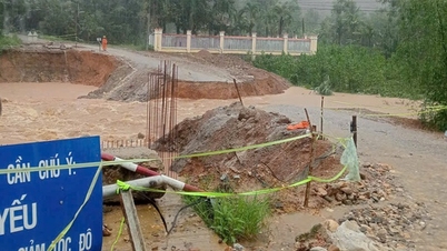
On the same day, the Department of Irrigation and Climate Change of Hue City requested communes and wards to urgently inspect and review residential areas along hills, rivers, streams, coastlines, and low-lying areas; proactively evacuate people from areas at risk of flash floods, landslides, and deep flooding; put up warning signs, arrange guards, and direct traffic at areas with deep flooding, fast-flowing water, or at risk of landslides.
Owners of reservoirs, hydroelectric dams, and irrigation works should strengthen safety inspections of works, especially in the upstream and downstream areas of dams, dam shoulders, and lake banks; promptly handle any landslide risks. Construction units, industrial parks, and riverside and coastal projects should proactively respond to heavy rains, strong winds, and high tides; ensuring safety for people, vehicles, and equipment.
Localities absolutely prohibit people and vehicles from passing through underground areas, areas with fast-flowing water, landslides, and deep flooding; prepare plans to evacuate people.
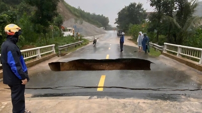
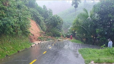
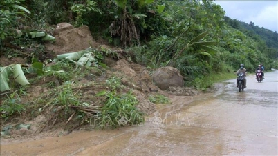
In Quang Ngai, heavy rains lasting for two days on October 25 and 26 caused landslides on many roads in mountainous communes of the province, and floodwaters on rivers and streams rose, disrupting traffic.
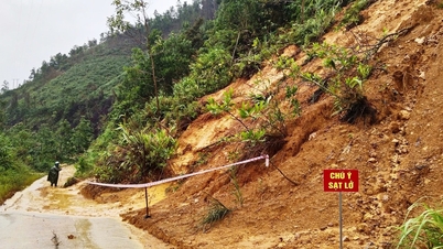
According to a quick report from the People's Committee of Tay Tra commune, on the afternoon of October 26, 9 landslides occurred in the commune due to heavy rain; in which, the road from Son village from group 4 to group 7; the road from Tra Bao village intersection to the People's Committee of Son Tra commune (old) was broken and landslides made it impossible for vehicles to circulate.

Heavy rain and landslides also caused landslides in the houses of 5 households of Mr. Ho Van Quyet, Ho Van Nuong, Ho Thi Mit, Tra Oi village and Ho Thanh Thuan and Ho Van Lanh, group 7, Tra Kem village. Chairman of Tay Tra Commune People's Committee Truong Cong Lam said that the landslides isolated and cut off traffic between 3 communes (old). The commune authorities sent forces to approach the landslide sites and assisted in evacuating 70 households in areas at high risk of landslides to safety.
Many landslides have also appeared in Tay Tra Bong and Thanh Bong communes. The landslide at Eo Ta Mo, Mon village and National Highway 24C, Thanh Bong commune caused a large amount of rock and soil to fall onto the road, causing traffic congestion. Thanh Bong Commune People's Committee has directed forces to put up warning signs, restricting people from passing through the landslide area, and at the same time organizing to restore traffic on the route. Tay Tra Bong Commune People's Committee has allowed students to stay home from school to ensure safety.
Currently, due to heavy rain, many locations in the province are flooded, including: Thach Nham spillway (about 0.7m deep); Binh Minh - Binh Chuong siphon, Phu Giang bridge, Song Giang bridge (about 0.7m deep); TL622B road (Ngoc Tri village section, Binh Chuong commune); National Highway 1A (VSIP industrial park) is partially flooded, functional forces have organized checkpoints and traffic guidance.
In Dak Plo commune, on the evening of October 26, the People's Committee of the commune completed the mobilization of evacuating 26 households, 116 people, mainly in the two villages of Bung Ton and Rooc Met, at risk of landslides and flash floods, to safe places at the homes of relatives and neighbors in the village.
Previously, due to the impact of storm No. 12, on October 25 and 26, heavy rains continued in Dak Plo commune, causing landslides and local flooding. The rain and floods affected many houses, properties, and crops of the people. 2 hectares of rice fields in Dak Book, Dak No, and Bung Ton villages were swept away by floodwaters and could not be restored. The rain and floods caused landslides in many sections of construction works, irrigation works, and the transportation system.
Specifically, the road from Dak Rooc Nam village to Dak Plo commune People's Committee; DH 81 road from Mang Khen village to the commune People's Committee had many landslides, trees fell; DH 83 road (Dak Pek commune to Dak Blo commune) had many landslides with large volumes of soil; some roads from Peng Lang village to Dak Book village had landslides on hills... The above roads are currently not accessible, causing 449 households with more than 1,500 people in Dak Book, Peeng Lang, Bung Ton and Bung Koong villages to be locally isolated...
Mr. Nguyen Van Vinh, Chairman of Dak Plo Commune People's Committee, said: To cope with the rain caused by storm No. 12, Dak Plo Commune People's Committee has mobilized the entire political system at the commune level, from departments, organizations, police forces, security and order teams, militia and self-defense forces... to prevent floods. The commune also proactively contacted businesses and construction units in the area to promptly support excavators to promptly handle flooding and local blockages.
For the isolated villages, tomorrow, October 27, if the weather is dry, the commune will provide vehicles and machinery supported by construction units to overcome landslides on key traffic routes in isolated villages. This is the heaviest damage since the beginning of the rainy season in Dak Plo. With the active and unanimous participation of the entire political system and the people, a combined strength has been created to overcome difficulties and help each other overcome disasters.
Quang Ngai Province Irrigation Department said that in the past two days, October 25-26, there was heavy to very heavy rain in Quang Ngai province (concentrated in the eastern communes of the province), rainfall at some stations such as: Tra Thanh: 434mm, Son Tra: 347mm; Huong Tra: 247mm, Tra Hiep: 320mm...
According to the forecast of the authorities, from the evening of October 26 to October 29, 2025, there will be a flood on the rivers in the province. During this flood, the flood peak on the Tra Bong, Tra Cau, Ve and Po Ko rivers will fluctuate at alert level 2 to alert level 3, the upstream of the Dak Bla and Tra Khuc rivers will fluctuate at approximately alert level 2 to above alert level 2.
Flood peak time is from the night of October 26 to October 27.
Source: https://baotintuc.vn/van-de-quan-tam/mua-lu-tai-mien-trung-gay-nhieu-thiet-hai-20251026223924166.htm
![[Photo] General Secretary To Lam received the delegation attending the international conference on Vietnam studies](https://vphoto.vietnam.vn/thumb/1200x675/vietnam/resource/IMAGE/2025/10/26/1761456527874_a1-bnd-5260-7947-jpg.webp)


![[Photo] Nhan Dan Newspaper displays and solicits comments on the Draft Documents of the 14th National Party Congress](https://vphoto.vietnam.vn/thumb/1200x675/vietnam/resource/IMAGE/2025/10/26/1761470328996_ndo_br_bao-long-171-8916-jpg.webp)
![[Photo] Enjoy the Liuyang Fireworks Festival in Hunan, China](https://vphoto.vietnam.vn/thumb/1200x675/vietnam/resource/IMAGE/2025/10/26/1761463428882_ndo_br_02-1-my-1-jpg.webp)


![[Photo] Prime Minister Pham Minh Chinh attends the opening of the 47th ASEAN Summit](https://vphoto.vietnam.vn/thumb/1200x675/vietnam/resource/IMAGE/2025/10/26/1761452925332_c2a-jpg.webp)


Comment (0)