

Cold air affects both land and sea areas
The National Center for Hydro-Meteorological Forecasting predicts that cold air has affected some places in the northern mountainous region.
It is forecasted that on the night of October 26 and on October 27, cold air will have a weak impact on other places in the Northeast and North Central regions, then affect some places in the Northwest and North Central regions. Northeast wind inland will be strong at level 2-3, coastal areas at level 3-4.
In the North and North Central regions, the night and morning are cold, and in the mountainous areas it is cold. The lowest temperature is generally 19-22 degrees Celsius, in the mountainous areas it is below 16 degrees Celsius. The average temperature is 23-25 degrees Celsius, in the mountainous areas it is below 22 degrees Celsius.
Night of October 27 and day of October 28: The North and North Central regions have the lowest temperature of 19-22 degrees Celsius, in mountainous areas some places below 17 degrees Celsius. Average temperature 23-25 degrees Celsius, in mountainous areas some places below 22°C.
Hanoi area is cold at night and morning, lowest temperature 19-22 degrees Celsius.
At sea: Bac Bo Gulf has strong northeast wind level 6, gusting to level 7-8, rough sea, waves 1.5-3.0m high.
The sea area north of the North East Sea (including the sea area north of Hoang Sa special zone) has strong northeast wind level 6, sometimes level 7, gusting to level 8-9, rough sea, waves 3-5m high.
The sea area from South Quang Tri to Quang Ngai has strong northeast wind level 5, sometimes level 6, gusting to level 7-8, waves 2-4m high, combined with high tide, rough sea.
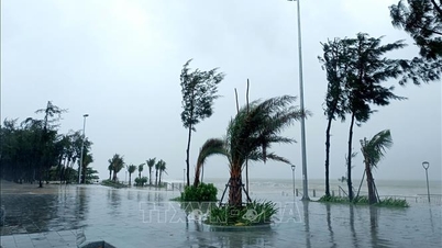
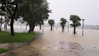
Due to the influence of cold air strengthening combined with disturbances in the upper easterly wind zone, the area from Ha Tinh to Da Nang city and the eastern part of the provinces from Quang Ngai to Dak Lak will have moderate rain, heavy rain and thunderstorms, locally very heavy rain.
Specifically, from the evening of October 26 to October 28, in the area from Hue city to Da Nang city and the east of Quang Ngai province, there will be heavy to very heavy rain with common rainfall of 250-450mm, locally over 600mm.
The area from Ha Tinh to Quang Tri and the eastern part of the provinces from Gia Lai to Dak Lak will have moderate rain, heavy rain and thunderstorms with common rainfall of 70-150mm, locally very heavy rain over 250mm. Warning of risk of heavy rain over 150mm/3 hours.
In addition, in the evening and night of October 26, in the Central Highlands, Khanh Hoa, Eastern Lam Dong and the Southern region, there will be rain, moderate rain and thunderstorms with rainfall of 20-40mm, locally heavy to very heavy rain over 100mm. Warning of the risk of heavy rain over 80mm/3 hours.
On the night of October 28 and October 29, the area from Quang Tri to Dak Lak will have moderate rain, heavy rain and thunderstorms with common rainfall from 50-150mm, locally very heavy rain over 300mm. Heavy rain in this area is likely to last until the end of October 2025.
Level 1 natural disaster risk due to heavy rain, tornado, lightning, hail
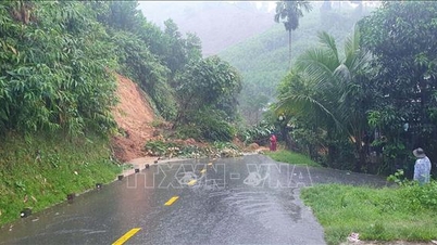
Heavy rains are likely to cause flooding in low-lying areas, urban and industrial areas; flash floods on small rivers and streams, landslides on steep slopes (real-time warning information on areas at risk of flash floods and landslides is provided online on the website of the Department of Hydrometeorology at: https://luquetsatlo.nchmf.gov.vn and in separate bulletins warning of flash floods and landslides).
"Thunderstorm areas are at risk of tornadoes, lightning, hail and strong gusts of wind," noted Deputy Head of Weather Forecasting Department Vu Anh Tuan.
Strong winds and large waves at sea affect fishing and fishing activities. Cold weather at night and morning can affect people's health.
Beware of flash floods and landslides from Hue to Khanh Hoa
According to the National Center for Hydro-Meteorological Forecasting, from 3:30 p.m. to 8:30 p.m. on October 26, the provinces/cities from Hue to Khanh Hoa will continue to have rain. There is a risk of flash floods and landslides in the above areas.
Specifically, the common accumulated rainfall is as follows: Quang Tri from 5-20mm, some places over 40mm; Hue city, Da Nang city from 50-80mm, some places over 120mm; Quang Ngai to Khanh Hoa from 30-60mm, some places over 50mm.
Warning of the risk of flash floods on small rivers and streams, landslides on steep slopes in many communes/wards: Ba Long, Dakrong, Hai Lang, Nam Hai Lang, Quang Tri, Ta Rut (Quang Tri province); A Luoi 1, A Luoi 4, A Luoi 5, Binh Dien, Chan May - Lang Co, Hung Loc, Khe Tre, Loc An, Long Quang, Nam Dong, Huong An, Huong Tra, Kim Long, Kim Tra, Phong Dien, Phong Thai, Phu Bai, Phu Loc; A Luoi 2, A Luoi 3, Vinh Loc (Hue city); Ba Na, Ben Giang, Chien Dan, Dong Duong, Duc Phu, Hiep Duc, Kham Duc, Lanh Ngoc, Nam Tra My, Nong Son, Son Tra, Phu Ninh, Phuoc Chanh, Phuoc Hiep, Phuoc Nang, Phuoc Thanh, Phuoc Tra, Que Phuoc, Que Son, Que Son Trung, Son Cam Ha, Tam My, Tam Xuan, Thang Phu, Thanh Binh, Tien Phuoc, Tra Doc, Tra Giap, Tra Leng, Tra Lien, Tra My, Tra Tan, Tra Tap, Tra Van, Viet An; Avuong, Dac Pring, Duy Xuyen, La Dee, La Ee, Nam Giang, Nui Thanh, Hai Van, Song Kon, Tam Anh, Tay Giang, Thu Bon, Tra Linh; Ben Hien, Dai Loc, Dong Giang, Ha Nha, Hoa Tien, Hoa Vang, Hung Son, An Khe, Hoa Khanh, Lien Chieu, Phu Thuan, Song Vang, Tay Ho, Thanh My, Thuong Duc, Vu Gia (Da Nang city).
Communes and wards in the provinces of Quang Ngai, Gia Lai, Dak Lak, and Khanh Hoa at risk of flash floods and landslides include: Ba Gia, Binh Chuong, Ca Dam, Dak Pek, Dak Plo, Dong Tra Bong, Ngoc Linh, Son Ha, Son Tay Thuong, Tay Tra, Tay Tra Bong, Thanh Bong, Tra Bong, Truong Giang, Xop; Binh Minh, Lan Phong, Mang But, Mang Ri, Nghia Giang, Son Ha, Son Linh, Son Tay, Son Tinh, and Tra Giang; Ba Dinh, Ba Dong, Ba To, Ba To, Ba Vi, Ba Vinh, Bo Y, Dak Ha, Dak Koi, Dak Long, Dak Mar, Dak Mon, Dak Pxi, Dak Ro Wa, Dak Sao, Dak To, Dak To Kan, Dang Thuy Tram, Dinh Cuong, Duc Nong, Ia Chim, Khanh Cuong, Kon Braih, Kon Dao, Kon Plong, Mang Den, Minh Long, Mo Duc, Ngok Bay, Ngok Reo, Ngok Tu, Nguyen Nghiem, Dak Cam, Duc Pho, Sa Huynh, Tra Cau, Phuoc Giang, Ro Koi, Sa Binh, Sa Loong, Son Ky, Son Mai, Son Tay Ha, Son Thuy, Thien Tin, Tu Mo Rong, Ve Giang (Quang Ngai province); An Hao, An Hoa, An Lao, An Vinh, Ayun, Dak Somei, Gao, Hra, Ia Bang, Ia Grai, Ia Hrung, Ia Khuol, Ia Tor, Krong, Mang Yang, Dien Hong, Hoi Phu (Gia Lai province); Hoa Xuan; Binh Kien, Dong Hoa, Tuy Hoa (Dak Lak province); Dai Lanh, Tu Bong, Van Thang (Khanh Hoa province).
Warning level of natural disaster risk due to flash floods, landslides, land subsidence due to heavy rain or level 1 flow.
Flash floods and landslides can have very negative impacts on the environment, threaten people's lives; cause local traffic congestion, affect the movement of vehicles; destroy civil and economic works, causing damage to production and socio-economic activities.
The hydrometeorological agency recommends that local authorities pay attention to reviewing bottlenecks and vulnerable locations in the area to have prevention and response measures.
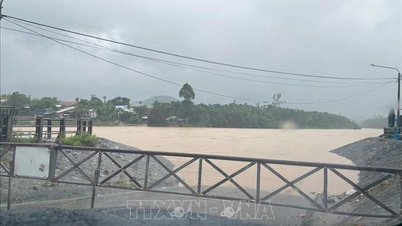
Risk of flooding in low-lying coastal areas in the Southeast region
The National Center for Hydro-Meteorological Forecasting said that in the next 24 hours, the highest water level at Vung Tau station will be 3.9 - 4m.
In the next 24 - 72 hours, the water level in the eastern coast of the South will continue to change slowly. The highest water level at Vung Tau station is likely to reach 3.85 - 3.95m.
Due to the impact of high tides, the eastern coastal area of the South needs to pay attention to prevent high risks of flooding and dike overflow in low-lying coastal and riverside areas, outside the dike, affecting traffic, agricultural production, aquaculture, water pollution and people's lives in the eastern coastal area of the South.
Weather in different regions on the night of October 26 and October 27
In the Northwest, there will be some rain; sunny in the afternoon, cold at night and in the morning. Light wind. Lowest temperature 18-21 degrees Celsius, some places below 17 degrees Celsius. Highest temperature 26-29 degrees Celsius.
In the Northeast, there will be rain in some places; in the afternoon, the clouds will become less cloudy and the sky will be sunny, at night and in the morning it will be cold, in the mountains it will be chilly. Northeast wind level 2-3. Lowest temperature 18-21 degrees Celsius, in the mountains, some places below 18 degrees Celsius. Highest temperature 26-29 degrees Celsius.
Hanoi City, no rain at night; sunny during the day, cold at night and morning. Northeast wind level 2-3. Lowest temperature 19-21 degrees Celsius. Highest temperature 27-29 degrees Celsius.
Provinces and cities from Thanh Hoa to Hue, the North has some rain; the South has moderate rain, heavy rain and thunderstorms, locally very heavy rain. Hue city alone has heavy to very heavy rain, cold at night and morning. North to Northwest wind level 2-3, in thunderstorms there is a possibility of tornadoes, lightning and strong gusts. Lowest temperature 19-22 degrees Celsius. Highest temperature in the North is 26-28 degrees Celsius, in the South 24-26 degrees Celsius.
The South Central Coast has heavy to very heavy rain; the South has rain, moderate rain and scattered thunderstorms, locally heavy to very heavy rain, with the possibility of tornadoes, lightning and strong gusts of wind. North to Northeast wind level 2-3. Lowest temperature 22-25 degrees Celsius. Highest temperature in the North 25-28 degrees Celsius, in the South 29-31 degrees Celsius.
The Central Highlands has rain, moderate rain and scattered thunderstorms, locally heavy to very heavy rain, with the possibility of tornadoes, lightning, hail and strong gusts of wind. Northeast to East wind level 2-3. Lowest temperature 19-22 degrees Celsius, some places below 19 degrees Celsius. Highest temperature 25-28 degrees Celsius.
The South has scattered showers and thunderstorms; in the late afternoon and at night there will be rain, moderate rain and scattered thunderstorms, locally heavy to very heavy rain, with the possibility of tornadoes, lightning, hail and strong gusts of wind. Lowest temperature 23-26 degrees Celsius. Highest temperature 29-32 degrees Celsius.
Ho Chi Minh City has showers and thunderstorms in some places; in the late afternoon and at night there will be rain, moderate rain and scattered thunderstorms, locally heavy to very heavy rain in some places, with the possibility of tornadoes, lightning, hail and strong gusts of wind. Lowest temperature 23-25 degrees Celsius. Highest temperature 28-30 degrees Celsius.
Source: https://baotintuc.vn/van-de-quan-tam/khong-khi-lanh-tang-cuong-nhet-do-o-bac-bo-va-bac-trung-bo-tiep-tuc-giam-20251026170821048.htm


![[Photo] General Secretary To Lam received the delegation attending the international conference on Vietnam studies](https://vphoto.vietnam.vn/thumb/1200x675/vietnam/resource/IMAGE/2025/10/26/1761456527874_a1-bnd-5260-7947-jpg.webp)
![[Photo] Nhan Dan Newspaper displays and solicits comments on the Draft Documents of the 14th National Party Congress](https://vphoto.vietnam.vn/thumb/1200x675/vietnam/resource/IMAGE/2025/10/26/1761470328996_ndo_br_bao-long-171-8916-jpg.webp)
![[Photo] Enjoy the Liuyang Fireworks Festival in Hunan, China](https://vphoto.vietnam.vn/thumb/1200x675/vietnam/resource/IMAGE/2025/10/26/1761463428882_ndo_br_02-1-my-1-jpg.webp)


![[Photo] Prime Minister Pham Minh Chinh attends the opening of the 47th ASEAN Summit](https://vphoto.vietnam.vn/thumb/1200x675/vietnam/resource/IMAGE/2025/10/26/1761452925332_c2a-jpg.webp)


Comment (0)