

Heavy rains and floods have caused serious landslides, cutting off many transportation routes in several mountainous areas of Da Nang city.
Severe landslides occurred in many mountainous areas.
In Tra Linh commune, heavy rains caused landslides on local roads, with an estimated volume of 5,000 cubic meters. Local authorities have evacuated 49 households/206 people (29 households in Kon Pin village, hamlet 2, and households along roads at high risk of landslides) to safe locations.
In Tra Leng commune, authorities evacuated 51 households/163 people to safe locations. At Tra Leng 1 Secondary School, 35 students remained on-site for safety reasons. Regarding transportation, the road to Hamlet 3 in Tra Leng commune, specifically the Den Pin residential area, is impassable for motorbikes due to landslides.
In Tra Doc commune, numerous landslides and floods occurred, forcing local authorities to evacuate 141 households/620 people. In Tra My commune, 71 households/250 people were also moved to safe locations.
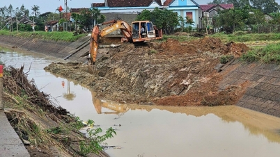
Notably, in Phuoc Chanh commune, roads in the area have suffered particularly severe landslides, with an estimated volume of over 10,000 m³ of soil and rocks burying many sections of road, cutting off traffic, and posing a risk of further landslides and safety hazards. Large landslide sites are currently inaccessible and cannot be repaired due to continued rain, soft soil, and a very high risk of further landslides.

Heavy rains and floods caused erosion and the collapse of a bridge on National Highway 24C in Tra Tan commune, Da Nang city.
The coastline of Hoi An continues to be severely eroded.
During this period of heavy rain, coastal areas were also severely affected. In Hoi An Tay ward, coastal erosion occurred along a stretch of more than 3km, with seawater encroaching 7-10m inland, and in some sections nearly 25-30m in, impacting residential areas inland. The People's Committee of Hoi An Tay ward has reported to the City People's Committee, seeking guidance on constructing a temporary embankment in the eroded area and planning to relocate approximately 30 businesses and 1 household affected if the erosion situation worsens.
Similarly, Hoi An Dong ward also experienced coastal erosion along a 450m stretch, with a width of 3-5m.
According to the Da Nang City Department of Construction, National Highway 40B has experienced subsidence and a broken culvert section downstream, damage at Km72+585, and a landslide on the embankment at Km121+850 (left side of the road), with a volume of approximately 500m3. Provincial Road 606 has also experienced a landslide on the embankment at Km65+100 (second landslide), with a volume of approximately 600m3. Currently, relevant authorities are mobilizing personnel and equipment to focus on repairs and reopen the roads as soon as possible.

A landslide flooded a house in Hamlet 1, Tra Tap Commune, Da Nang City.
Continued heavy rain increases the risk of flash floods and landslides.
According to the Central Region Meteorological and Hydrological Station, in the past 6 hours (from 11:00 AM on October 26th to 5:00 PM on October 26th), Da Nang city experienced heavy to very heavy rainfall, including: Tra Don 226.4mm, Tam Tra 80.2mm, and Tra My 41.0mm.
Soil moisture models indicate that some areas in Da Nang City are nearing saturation (over 95%).
Over the next 6 hours, heavy to very heavy rain will continue in Da Nang city. Total rainfall in the northern communes and wards will generally range from 30-80mm, with some areas exceeding 120mm. There is a risk of flash floods on small rivers and streams in mountainous areas; landslides on slopes, and land subsidence in many communes and wards of Da Nang city.
From tonight until October 29th, a flood is likely to occur on the rivers in Da Nang city. The flood peak on the Vu Gia-Thu Bon river will fluctuate at level 3 to above level 3; the Han and Tam Ky rivers will be at level 2 to above level 2.
Today, due to heavy rainfall upstream, the water inflow into the reservoirs is high, and hydroelectric reservoirs in Da Nang city have continuously adjusted and increased the water discharge rate through the spillways.
Specifically, from 2 PM on October 26th, the Song Tranh 2 hydropower reservoir announced an increase in the discharge rate through the spillway from 10 to 5,950 m3/s. At noon the same day, the Dak Mi 4 hydropower reservoir increased its discharge rate through the spillway from 500 to 4,500 m3/s.
Other hydroelectric reservoirs such as Song Bung 2, Song Bung 4, and A Vuong also issued notices to release water to cope with heavy rainfall.
Nhat Anh
Source: https://baochinhphu.vn/da-nang-so-tan-khan-cap-hang-tram-ho-dan-ra-khoi-khu-vuc-sat-lo-102251026201906544.htm


![[Photo] Prime Minister Pham Minh Chinh holds a phone call with the CEO of Russia's Rosatom Corporation.](/_next/image?url=https%3A%2F%2Fvphoto.vietnam.vn%2Fthumb%2F1200x675%2Fvietnam%2Fresource%2FIMAGE%2F2025%2F12%2F11%2F1765464552365_dsc-5295-jpg.webp&w=3840&q=75)
![[Photo] Closing Ceremony of the 10th Session of the 15th National Assembly](/_next/image?url=https%3A%2F%2Fvphoto.vietnam.vn%2Fthumb%2F1200x675%2Fvietnam%2Fresource%2FIMAGE%2F2025%2F12%2F11%2F1765448959967_image-1437-jpg.webp&w=3840&q=75)


Comment (0)