
The working group recorded 3 locations of mountain cracks, with the risk of landslides. The first location, about 2km from the residential area, had a landslide with an estimated volume of 3,000 - 5,000m³. Below the landslide point, a stream of murky water with an unknown source appeared.

At the second location, about 200m from the first location, a crack about 30m long and 0.3 - 0.5m wide appeared. At the third location, about 150m away, a water hole nearly 8m² wide formed, with water flowing down from above but not escaping.

According to Mr. Thanh Minh Thuan, Chairman of the People's Committee of Ba Vi commune, these unusual signs pose a risk of serious landslides if heavy rain continues, directly threatening 77 households with nearly 300 people in group 1, group 4 of Ta Noat village, and a number of households in Ta Gam village (Son Ky commune) living at the foot of Wang Voi mountain.

Mr. Thuan said that the Commune People's Committee has proactively developed a plan to evacuate people from areas at risk of landslides, while closely monitoring weather and geological developments. "When there are floods, we will immediately evacuate households to safe places, and at the same time propose that the province support necessities, funding and direct relevant agencies to survey and find long-term solutions for people at the foot of the mountain," Mr. Thuan said.
Source: https://www.sggp.org.vn/phat-hien-nhieu-vet-nut-tren-nui-wang-voi-quang-ngai-post822478.html
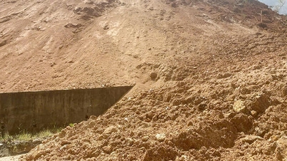
![[Photo] Cutting hills to make way for people to travel on route 14E that suffered landslides](https://vphoto.vietnam.vn/thumb/1200x675/vietnam/resource/IMAGE/2025/11/08/1762599969318_ndo_br_thiet-ke-chua-co-ten-2025-11-08t154639923-png.webp)


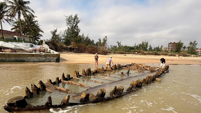
![[Photo] "Ship graveyard" on Xuan Dai Bay](https://vphoto.vietnam.vn/thumb/1200x675/vietnam/resource/IMAGE/2025/11/08/1762577162805_ndo_br_tb5-jpg.webp)


![[Video] Hue Monuments reopen to welcome visitors](https://vphoto.vietnam.vn/thumb/402x226/vietnam/resource/IMAGE/2025/11/05/1762301089171_dung01-05-43-09still013-jpg.webp)


Comment (0)