
Today (July 22), Typhoon Wipha (Typhoon No. 3) will make landfall in the area from Hai Phong to Thanh Hoa with strong winds near the center of the storm reaching levels 10-11 (89-117 km/h), gusting to level 13.
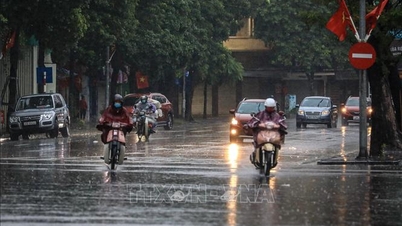
According to the National Center for Hydro-Meteorological Forecasting, moderate to heavy rain, and in some places very heavy rain, occurred in the northern delta and coastal areas, Thanh Hoa, and Nghe An provinces , with rainfall amounts generally ranging from 50-100mm, and exceeding 130mm in some areas.

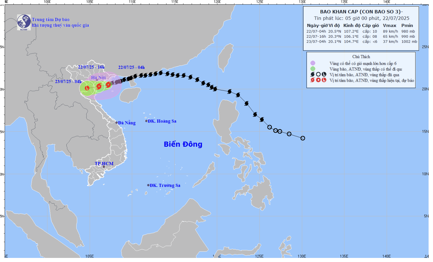
The trajectory of Typhoon Wipha (Typhoon No. 3). Source: NCHMF
In the Bach Long Vi special zone, there were strong winds of level 10, gusting to level 12; Co To level 8, gusting to level 11; Cat Ba (Cat Hai special zone) level 6, gusting to level 8; Cua Ong level 9, gusting to level 12; Bai Chay level 8, gusting to level 9; Quang Ha level 8; Tien Yen level 7, gusting to level 9; Thai Binh station level 7, gusting to level 8; Mong Cai level 6, gusting to level 9; Phu Lien level 6, gusting to level 8;…
As of 4:00 AM today (July 22nd), the storm's center was located approximately 140km from Quang Ninh, 70km from Hai Phong, 80km from Hung Yen, and 100km from Ninh Binh. The strongest winds near the storm's center were at level 9-10.
(75-102 km/h), gusts up to level 13; moving in a west-southwest direction at a speed of approximately 15 km/h.
Over the next 12 hours, the storm will continue to move west-southwest at 10-15 km/h. By 4 PM on the same day, the storm's center will be located inland between Hai Phong and Thanh Hoa with wind speeds of level 8, gusting to level 10; and will weaken over the Vietnam-Laos border area.
Due to the influence of typhoon No. 3, the northern part of the Gulf of Tonkin (including the special zones of Bach Long Vi, Co To, Van Don, Cat Hai, and Hon Dau Island) will experience strong winds of force 7-8, reaching force 9-10 near the center of the typhoon, with gusts up to force 13; sea waves will be 2-4m high, reaching 3-5m near the center of the typhoon; the sea will be very rough.
The southern part of the Gulf of Tonkin (including Hon Ngu Island) will experience strong winds of force 6-7, with gusts of force 8 near the storm's center.
Level 11; sea waves 2-4m high; rough seas.
Coastal areas of Hung Yen and Quang Ninh provinces are experiencing storm surges of 0.5-1 meter. Water levels at Ba Lat (Hung Yen) are 2.4-2.6 meters, Hon Dau (Hai Phong) 3.9-4.1 meters, Cua Ong (Quang Ninh) 4.6-5.0 meters, and Tra Co (Quang Ninh) 3.6-4.0 meters. There is a high risk of flooding in coastal and river mouth areas around noon and afternoon of July 22nd.
The meteorological agency warns: Weather conditions at sea and in coastal areas during the storm are extremely dangerous and unsafe for any vehicles or structures operating in the hazardous zone, such as: tourist boats, passenger ships, cargo ships, cages, rafts, aquaculture farms, dikes, embankments, and coastal roads. Vehicles are at high risk of capsizing, destruction, or flooding due to strong winds, thunderstorms, tornadoes, large waves, and rising sea levels.
On land, coastal areas from Quang Ninh to Nghe An will experience strong winds of force 7-8, near the storm's center force 9-10, gusting to force 13; inland areas of Hai Phong, Hung Yen, Bac Ninh, Hanoi, Ninh Binh, and Thanh Hoa provinces/cities will experience strong winds of force 6, gusting to force 7-8. Winds of force 9-10 can knock down trees, power poles, and tear off roofs, causing very heavy damage.
From early morning on July 22-23, heavy to very heavy rain and thunderstorms occurred in the Northern Delta region, Thanh Hoa and Nghe An provinces, with rainfall amounts generally ranging from 200-300mm, and exceeding 500mm in some areas; other areas in the Northern region and Ha Tinh province experienced moderate to heavy rain, with very heavy rain and thunderstorms in some areas, with rainfall amounts generally ranging from 70-150mm, and exceeding 250mm in some areas.
Warning of high rainfall intensity (>150mm/3h). Heavy rainfall in a short period of time can cause flash floods and landslides in mountainous areas, and flooding in low-lying areas.
Vietnamnet.vn
Source: https://vietnamnet.vn/tin-moi-nhat-bao-so-3-wipha-tam-bao-rat-gan-hai-phong-hung-yen-ninh-binh-2424322.html

![[Photo] Prime Minister Pham Minh Chinh attends the Conference summarizing and implementing tasks of the judicial sector.](/_next/image?url=https%3A%2F%2Fvphoto.vietnam.vn%2Fthumb%2F1200x675%2Fvietnam%2Fresource%2FIMAGE%2F2025%2F12%2F13%2F1765616082148_dsc-5565-jpg.webp&w=3840&q=75)


Comment (0)