
According to the Provincial Steering Committee for Disaster Prevention and Search and Rescue, from 7 PM on February 22nd to 3 PM on February 24th, the province experienced heavy to very heavy rainfall, with common rainfall amounts ranging from 80-150mm, and some areas experiencing localized heavy rainfall exceeding 150mm (An Xuan: 189.6mm; Son Dinh: 190.6mm…).
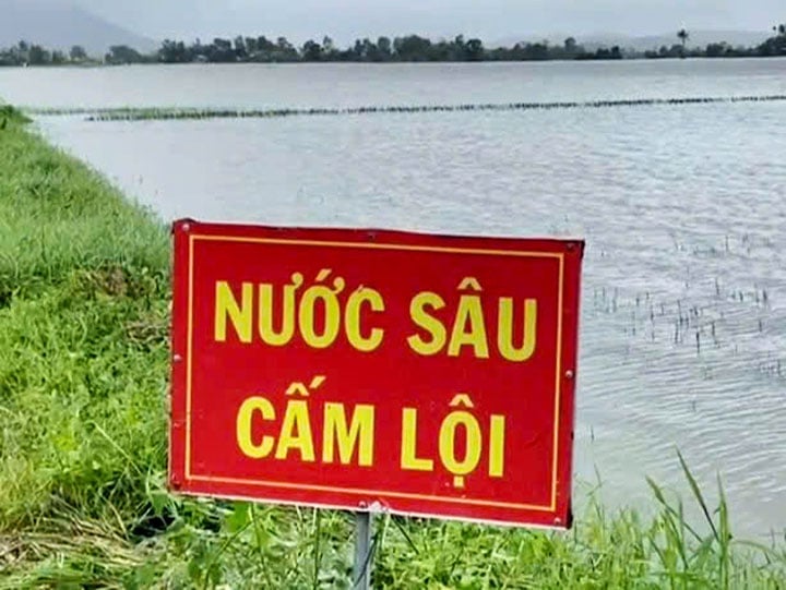 |
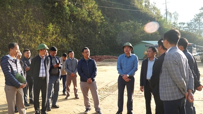
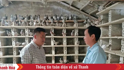
| Local authorities in Tay Hoa district have put up warning signs in flooded areas to alert residents. Photo: ANH NGOC |
Water levels on rivers in the province are below alarm level 1, except for the Ban Thach River, where water levels have risen above alarm level 2. On February 24th, at 11:00 AM at the Hoa My Tay station, the water level was 12.13m, 0.13m above alarm level 2; at 1:00 PM at the Hoa My Tay station, it was 12.05m, 0.05m above alarm level 2, with water levels receding slowly. It is predicted that within the next 6-12 hours, the flood level on the Ban Thach River may rise again to approximately alarm level 2.
According to preliminary reports from local authorities, the heavy rains from February 22-24 caused flooding and damage to agricultural production and infrastructure. As of 4 PM on February 24, approximately 3,835 hectares of rice crops for the 2024-2025 winter-spring season were flooded and damaged (Tay Hoa, Phu Hoa, Tuy An, Song Hinh, Dong Hoa, and Tuy Hoa City); and over 1,260 hectares of other crops and annual plants (cassava) were flooded and damaged (Tay Hoa, Phu Hoa, and Song Hinh).
Hydropower reservoir owners in the province have closely monitored the rainfall and flood situation in the river basin, organizing the operation, regulation, storage, and discharge of water through spillways according to procedures. On February 24th, at 13:00, the Song Ba Ha hydropower reservoir reached a level of 104.42m (design water level is 105m), with an inflow of 40m³ /s; at 15:00, the Song Hinh hydropower reservoir reached a level of 208.99m (design water level is 209m), with an inflow of 553m³ /s, and a total discharge through spillways and turbines of 553m³ /s; at 13:00, the Krong Hnang hydropower reservoir reached a level of 254.32m (design water level is 255m), with an inflow of 267.5m³ /s, and a discharge through spillways of approximately 67m³ /s.
In Phu Yen province, there are currently 51 irrigation reservoirs, of which 4 are large, with a common capacity of 78-100%, including: My Lam (91.38%), Dong Tron (100%), Phu Xuan (100%) and Suoi Vuc (79.36%), these reservoirs are regulating water discharge through spillways. The remaining irrigation reservoirs are storing water commonly from 80-100% compared to the design capacity. The reservoir owners organize to closely monitor the development of rain and floods; observe, calculate, operate and regulate reservoirs according to procedures and regulations.
The Provincial Steering Committee for Disaster Prevention and Search and Rescue requests that localities and units continue to closely monitor weather forecasts and warnings regarding heavy rain, flooding, and landslides to proactively implement response and remediation plans promptly, ensuring the safety of people and property. They should proactively implement plans to protect production, ensure the safety of infrastructure, especially vulnerable dikes and embankments, and unfinished construction projects along rivers, streams, and the coast. They should inspect and review residential areas along rivers, streams, and riverbanks, and areas at risk of flooding; and prepare evacuation plans for high-risk areas to safe locations. They should proactively implement response plans for heavy rain, floods, landslides, and other potential adverse situations.
MR. NGOC
Source: https://baophuyen.vn/82/326277/trien-khai-cac-phuong-an-bao-ve-san-xuat-dam-bao-an-toan-cong-trinh.html


![[Video] The craft of making Dong Ho folk paintings has been inscribed by UNESCO on the List of Crafts in Need of Urgent Safeguarding.](https://vphoto.vietnam.vn/thumb/402x226/vietnam/resource/IMAGE/2025/12/10/1765350246533_tranh-dong-ho-734-jpg.webp)


Comment (0)