
Early on the morning of November 10, storm Fung-Wong entered the eastern sea of the North East Sea, becoming the 14th storm in 2025.
According to the National Center for Hydro-Meteorological Forecasting, at 4:00 a.m. on November 10, the center of the storm was located at about 17.3 degrees North latitude; 119.3 degrees East longitude, in the eastern sea area of the North East Sea. The strongest wind near the center of the storm was level 13 (134-149 km/h), gusting to level 16. Moving in the West Northwest direction, speed about 25 km/h.
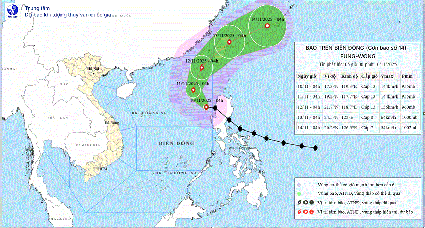 |
Forecast, by 4am on November 11, the storm will be at 19.2N-117.7E in the eastern sea of the North East Sea; Level 13, gusting to level 16. Moving northwest about 10-15km
4am on November 12, storm at 21.7N-118.7E in the northeastern sea of the North East Sea area; Level 13, gust level 16. Moving North Northeast about 10-15km
4am on November 13, storm at 26.2N-126.5E on the northeastern coastal area of Taiwan island; Level 8, gust level 10. Moving northeast about 15-20km
Warning, from the next 72 to 96 hours, the storm will move in the East Northeast direction, 20-25km per hour and continue to weaken.
The eastern sea area of the North East Sea has strong winds of level 8-10; the area near the storm's eye has strong winds of level 11-13, gusts of level 16, waves 5.0-8.0m high, the area near the storm's eye has waves of 8.0-10.0m. The sea is very rough.
It is recommended that all boats operating in the above mentioned dangerous areas are at risk of being affected by storms, whirlwinds, strong winds and large waves.
According to PV/VOV.VN
Source: https://baovinhlong.com.vn/thoi-su/202511/bao-fung-wong-vao-bien-dog-tro-thanh-bao-so-14-manh-cap-13-giat-cap-16-73306f0/


![Dong Nai OCOP transition: [Article 3] Linking tourism with OCOP product consumption](https://vphoto.vietnam.vn/thumb/402x226/vietnam/resource/IMAGE/2025/11/10/1762739199309_1324-2740-7_n-162543_981.jpeg)


Comment (0)