

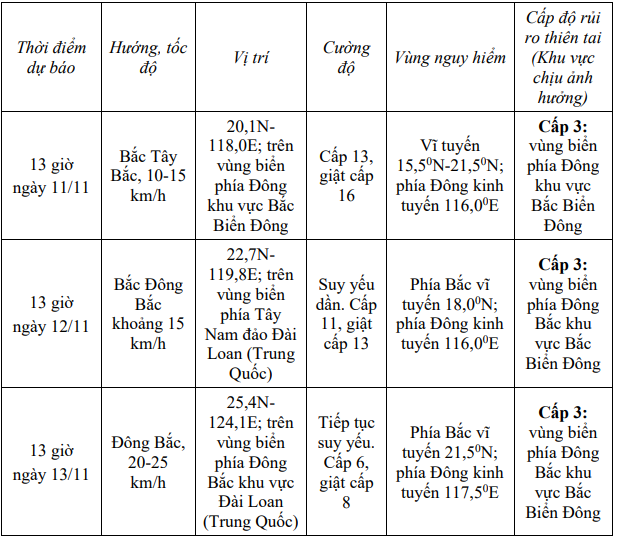
The National Center for Hydro-Meteorological Forecasting informed that at 1:00 p.m. on November 10, the center of storm No. 14 was at about 17.5 degrees North latitude; 118.8 degrees East longitude, in the eastern sea area of the North East Sea.
The strongest wind near the storm center is level 13 (134-149km/h), gusting to level 16. The storm is moving northwest at a speed of about 10km/h.
Storm forecast (in the next 24 to 72 hours)
Forecasting the impact of storms
Due to the storm's influence, the eastern sea area of the North East Sea has strong winds of level 8-10; the area near the storm's eye has strong winds of level 11-13, gusts of level 16, waves 5-8m high, the area near the storm's eye has waves of 8-10m. The sea is very rough.
All vessels operating in the above mentioned danger zones are susceptible to the effects of storms, whirlwinds, strong winds and large waves.
Source: https://baolaocai.vn/bao-so-14-duy-tri-cuong-do-gio-giat-cap-16-huong-vao-dai-loan-trung-quoc-post886487.html


![Dong Nai OCOP transition: [Article 3] Linking tourism with OCOP product consumption](https://vphoto.vietnam.vn/thumb/402x226/vietnam/resource/IMAGE/2025/11/10/1762739199309_1324-2740-7_n-162543_981.jpeg)


Comment (0)