
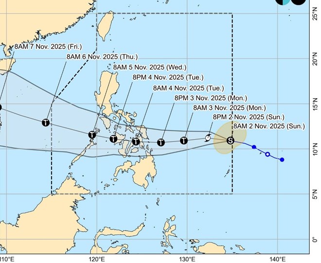
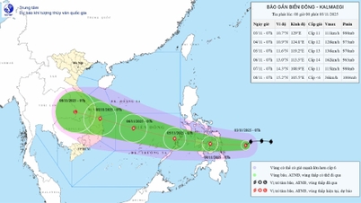
Forecast path of typhoon Kalmaegi (Tino), precursor of typhoon No. 13 in the East Sea. Photo: PAGASA
The Philippine Atmospheric, Geophysical and Astronomical Services Administration (PAGASA) warned that Typhoon Kalmaegi (locally known as Typhoon Tino) is on a rapid intensification trend in the next 48 hours and may make landfall as a strong typhoon in Eastern Samar or Dinagat Islands on the evening of November 3 or early morning of November 4.
According to the latest storm news released at 11:00 a.m. on November 2, the eye of the storm was located at approximately 11.1 degrees north latitude; 134.5 degrees east longitude, 955 km east of Visayas. The strongest wind near the eye of the storm was 85 km/h, gusting to 105 km/h, moving west at 30 km/h.
It is forecast that in the next 24 hours, storm Kalmaegi will rapidly intensify into a strong storm, with winds of about 150-155 km/h when approaching land.
PAGASA stressed that “the possibility of the storm reaching super typhoon level cannot be ruled out,” based on current climate data and simulation scenarios.
It is forecast that in the next 3 days, Typhoon Kalmaegi will move mainly westward, making landfall in eastern Samar or Dinagat Islands on the evening of November 3 or early morning of November 4, then crossing the Visayas region and northern Palawan before heading out to the East Sea, becoming storm No. 13 on November 5.
Storm No. 13 is forecast to approach the South Central Coast to the Central region of Vietnam around the evening of November 6 and the morning of November 7 with level 13 winds, gusting to level 15-16.
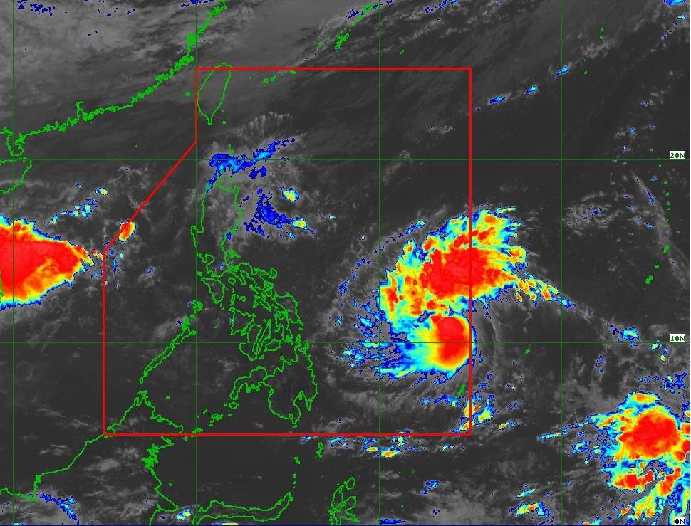
PAGASA has issued a Strong Wind Signal Level 1 warning for eastern Samar, Dinagat, Siargao and Bucas Grande, which may experience light to moderate strong winds in the next 24 hours. The highest warning signal is expected to reach Level 4 if the storm continues to intensify as forecast.
PAGASA warned that storm surges could cause coastal flooding in many low-lying areas in the Visayas, southern Luzon and Mindanao. The highest risk is concentrated in areas located near or north of the projected path of the eye of the typhoon.
The agency also said that a strong wind warning at sea may be issued on the evening of November 2 or the morning of November 3 for the eastern Visayas and Caraga seas due to waves of 3-4 meters high.
Typhoon Tino is expected to bring heavy rains to the Philippines. Photo: PAGASA
From noon on November 3 to noon on November 4, rains of 100-200 mm (heavy to very heavy rain) are forecast to occur in eastern Samar, southern Leyte, Leyte, Cebu, Bohol, Dinagat, Surigao del Norte and Agusan del Norte.
When entering the East Sea and approaching the coast of Vietnam, the storm's wind-affected area is forecast to be very wide because when approaching the shore, the storm tends to move in a west-northwest direction along the coastal provinces from Khanh Hoa to Hue. The storm's rain-affected area is very wide from Ninh Thuan to Nghe An.
Currently, according to the Vietnam National Center for Hydro-Meteorological Forecasting, the tropical convergence zone has an axis at about 11-14 degrees north latitude connecting with the low pressure area located at 7:00 a.m. on November 2 at about 12.5-13.50 degrees north latitude; 111.5-112.50 degrees east longitude.
The sea area from the south of Quang Tri to Quang Ngai , the Gulf of Thailand, the sea area south of the northern East Sea (including Hoang Sa special zone), and the central East Sea area has scattered showers and thunderstorms. In the Gulf of Tonkin, there are strong northeast winds of level 5, sometimes level 6, gusting to level 7.
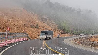
In the next 6 hours, there is a risk of flash floods, landslides, and land subsidence on steep slopes and small streams in the provinces of Ha Tinh, Quang Tri, Hue city, Da Nang city, Quang Ngai, and Gia Lai.
Laodong.vn
Source: https://laodong.vn/the-gioi/bao-so-13-tiem-nang-manh-nhanh-du-bao-vung-do-bo-dau-tien-1602415.ldo
![[Photo] Ho Chi Minh City Youth Take Action for a Cleaner Environment](https://vphoto.vietnam.vn/thumb/1200x675/vietnam/resource/IMAGE/2025/11/04/1762233574890_550816358-1108586934787014-6430522970717297480-n-1-jpg.webp)

![[Photo] Panorama of the Patriotic Emulation Congress of Nhan Dan Newspaper for the period 2025-2030](https://vphoto.vietnam.vn/thumb/1200x675/vietnam/resource/IMAGE/2025/11/04/1762252775462_ndo_br_dhthiduayeuncbaond-6125-jpg.webp)

![[Photo] The road connecting Dong Nai with Ho Chi Minh City is still unfinished after 5 years of construction.](https://vphoto.vietnam.vn/thumb/1200x675/vietnam/resource/IMAGE/2025/11/04/1762241675985_ndo_br_dji-20251104104418-0635-d-resize-1295-jpg.webp)
![[Photo] Ca Mau "struggling" to cope with the highest tide of the year, forecast to exceed alert level 3](https://vphoto.vietnam.vn/thumb/1200x675/vietnam/resource/IMAGE/2025/11/04/1762235371445_ndo_br_trieu-cuong-2-6486-jpg.webp)


Comment (0)