
According to the National Center for Hydro-Meteorological Forecasting, at 1:00 p.m. on September 19, the eye of the storm was located at about 22.6 degrees North latitude; 115.2 degrees East longitude, on the coastal area of Guangdong province (China), about 120km east of Hong Kong (China). The strongest wind near the eye of the storm was level 9 (75-88km/h), gusting to level 11. Moving northwest at a speed of 10-15km/h.
At 1:00 a.m. on September 20, the storm was on land in the southern part of Guangdong province (China); moving in the West-Northwest direction at a speed of about 10-15 km/h with strong winds of level 6-7, gusting to level 9. The affected area is the northern sea area of the North East Sea. Disaster risk level 3.
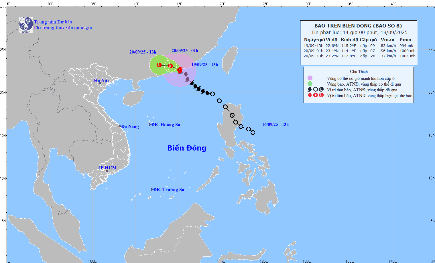
At 1 p.m. on September 20, the storm was on the mainland south of Guangdong province (China); moving west at a speed of 15 km/h, entering the mainland and gradually weakening into a low pressure area. Wind force below level 6.
Due to the storm's influence, the northern sea area of the North East Sea has strong winds of level 6-7, gusting to level 9; the area near the storm's eye has strong winds of level 8-9, gusting to level 11, waves 3-5m high, very rough seas.
Vessels operating in the above mentioned dangerous areas are susceptible to the impact of storms, whirlwinds, strong winds and large waves.
On land, according to information from the National Center for Hydro-Meteorological Forecasting, from 2:30 p.m. to 7:30 p.m. on September 19, Phu Tho province will continue to have rain with accumulated rainfall ranging from 20-40mm, in some places over 70m.
Warning of the risk of flash floods on small rivers and streams, landslides on steep slopes, especially in the communes/wards of Yen Thuy, Yen Tri; An Binh, Dai Dong, Dung Tien, Kim Boi, Lac Luong, Lac Son, Ngoc Son, Nhan Nghia, Yen Phu.
Level of natural disaster risk due to flash floods, landslides, land subsidence due to heavy rain or level 1 flow.
From 10:00 to 13:00, Phu Tho province had moderate to heavy rain such as: Yen Tri 79.4mm, Yen Thuy 50.4mm, Doan Ket 38.4mm,...
Source: https://baolaocai.vn/bao-so-8-giat-cap-11-huong-ve-phia-nam-tinh-quang-dong-trung-quoc-post882486.html


![Dong Nai OCOP transition: [Article 3] Linking tourism with OCOP product consumption](https://vphoto.vietnam.vn/thumb/402x226/vietnam/resource/IMAGE/2025/11/10/1762739199309_1324-2740-7_n-162543_981.jpeg)


Comment (0)