
 |
| Mr. Hoang Phuc Lam, Deputy Director of the National Center for Hydro-Meteorological Forecasting (Department of Hydro-Meteorology, Ministry of Agriculture and Environment ) informed about storm number 3. |
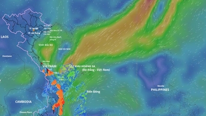
As of 11:00 a.m. on July 19, the storm was operating at level 9, up one level from 24 hours earlier, and was about 1,000 km east of Leizhou Peninsula (China). With an average moving speed of about 20 km/h, the storm tends to continue to strengthen, reaching level 12-13, gusting to level 14-15 when moving to the area east of Leizhou Peninsula. It is forecasted that when entering the Gulf of Tonkin, the storm will gradually weaken, with an intensity of about level 8-10.
Notably, Mr. Lam emphasized that this is a strong storm, moving quickly, with rain clouds and strong winds shifting to the west and south. Therefore, from July 20 to July 21, when the storm is still offshore in the Gulf of Tonkin, thunderstorms before the storm are likely to occur in the sea and coastal areas of the North.
According to the National Center for Hydro-Meteorological Forecasting, in the next 24 hours, the greatest risk caused by the storm is strong winds and high waves in the northern and central areas of the East Sea, especially the sea area north of the Hoang Sa archipelago, where winds of level 10-12, gusts of level 15, and waves of 4m-6m high may be recorded.
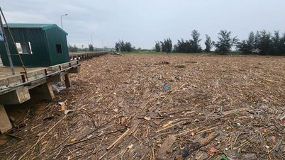
From July 20 to 21, areas such as Bach Long Vi, Co To, Cat Hai... are likely to be significantly affected by strong winds and heavy rain. By early morning and on July 22, coastal areas from Quang Ninh to Thanh Hoa provinces will begin to be directly affected by the storm with strong winds of level 7-9, waves from 3m-5m high. Large waves combined with high tides can cause flooding in low-lying areas along the coast of Quang Ninh and Hai Phong from noon and afternoon of July 21 to July 23.
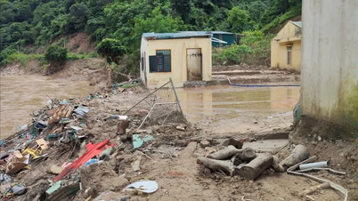
On land, the storm's impact is widespread in the Northeast region, some places in the Northwest and North Central regions. Quang Ninh, Hai Phong, Hung Yen, Ninh Binh, Thanh Hoa provinces are considered to be the areas most directly and strongly affected. Widespread heavy rain is forecast to occur in the North and from Thanh Hoa to Ha Tinh from July 21 to July 24. Some places may experience localized rain with rainfall of more than 150mm within 3 hours.
Notably, from July 21 to July 24, there is a possibility of a flood with a flood amplitude of 3m-6m on rivers in the North, Thanh Hoa and Nghe An. There is a high risk of flooding in low-lying areas along rivers, urban areas, residential areas, as well as flash floods and landslides in mountainous areas of the North, Thanh Hoa and Nghe An.
The National Center for Hydro-Meteorological Forecasting recommends that localities, units and people closely monitor the storm's developments, proactively deploy timely response measures, and ensure safety for people and property.
Source: https://huengaynay.vn/chinh-tri-xa-hoi/theo-dong-thoi-su/bao-wipha-di-chuyen-nhanh-kha-nang-gay-mua-lon-tren-dien-rong-155835.html
![[Photo] General Secretary To Lam meets with General Secretary and President of Laos Thongloun Sisoulith](https://vphoto.vietnam.vn/thumb/1200x675/vietnam/resource/IMAGE/2025/10/25/1761380913135_a1-bnd-4751-1374-7632-jpg.webp)


![[Photo] President Luong Cuong receives heads of delegations attending the signing ceremony of the Hanoi Convention](https://vphoto.vietnam.vn/thumb/1200x675/vietnam/resource/IMAGE/2025/10/25/1761377309951_ndo_br_1-7006-jpg.webp)
![[Photo] President Luong Cuong and United Nations Secretary-General Antonio Guterres chaired the signing ceremony of the Hanoi Convention.](https://vphoto.vietnam.vn/thumb/1200x675/vietnam/resource/IMAGE/2025/10/25/1761370409249_ndo_br_1-1794-jpg.webp)


Comment (0)