
Armed forces of Military Region 5 are assisting people in responding to flooding in Hoi An.
According to the Central Vietnam Regional Hydrometeorological Station, water levels on rivers in Da Nang City are currently rising rapidly. At 1 PM on October 27th, water levels on the Vu Gia River at Hoi Khach and Ai Nghia had exceeded alarm level 3.
The Thu Bon River at Nong Son, Giao Thuy, Cau Lau, and Hoi An is at flood level 3 (BĐ3). The Han River at Cam Le is at flood level 1 (BĐ1); the Tam Ky River at Tam Ky is below flood level 1 (BĐ1).
Forecast for the next 6 to 12 hours: Floods on the Vu Gia - Thu Bon rivers will rise above Level 3 (BĐ3). The peak flood level on the Vu Gia River at Ai Nghia will be 10.3 m (1.30 m above BĐ3, lower than the exceptionally large flood of 2007 by 0.06 m, higher than 2017 by 0.19 m ), and at Cam Le it will be 2.8 m (0.3 m above BĐ3).
On the Thu Bon River at Giao Thuy, the water level is 10.0 m, 1.2 m above flood level 3 (0.4 m higher than the exceptionally large flood in 2007, 0.5 m higher than in 2017 ); at Cau Lau, the water level is 5.1 m, 1.1 m above flood level 3 ( 0.29 m lower than the exceptionally large flood in 2007, equivalent to 2017 ); at Hoi An, the water level is 3.0 m, 1.0 m above flood level 3 (0.17 m higher than in 2017 ); the Tam Ky River is approximately at flood level 1.
From the next 12 to 24 hours, floods in the lower reaches of the Vu Gia - Thu Bon River will peak and be above Level 3; the Tam Ky River will be at Level 1-2.
Rising water levels on the Vu Gia - Thu Bon river system will cause widespread and deep flooding in low-lying areas along the riverbanks, and waterlogging in urban areas. This will particularly affect the following communes: Que Phuoc, Nong Son, Duy Xuyen, Thu Bon, Xuan Phu, Thanh My, Thuong Duc, Ha Nha, Phu Thuan, Vu Gia, Dai Loc, Go Noi, Dien Ban Tay, Dien Ban Bac, Hoa Tien, Hoi An, Hoi An Tay, Hoi An Dong, Nam Phuoc, Duy Nghia, An Thang...
There is a very high risk of flash floods and landslides on the slopes of the mountainous areas of Da Nang City.
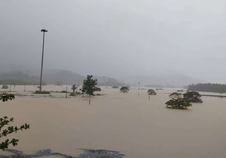
Heavy rains and flooding in recent days have inundated many areas in Da Nang city.
Warning of high rainfall risk (>200 mm/3 hours) in mountainous areas.
According to the Central Vietnam Regional Hydrometeorological Station, from noon on October 26th to noon on October 27th, moderate to heavy rain, and even very heavy rain, occurred in the communes and wards of Da Nang city. The total rainfall from 7 PM on October 26th to 12 PM on October 27th in the plains was generally 50-100 mm, with some areas receiving more; in the mountainous areas, it was generally 150-250 mm, with some areas exceeding 300 mm, such as Nong Son (377.4 mm) and Ba Na (367.0 mm).
Forecasts indicate moderate to heavy rain and thunderstorms in communes and wards of Da Nang city from this afternoon (October 27th) to the afternoon of October 29th. Total rainfall in lowland communes and wards will generally range from 200-350 mm, with some areas exceeding 450 mm; mountainous communes and wards will generally receive 250-500 mm, with some areas exceeding 750 mm. A warning is issued regarding the risk of heavy rainfall exceeding 200 mm/3 hours in mountainous areas.
Mr. Truong Xuan Ty, Deputy Director of the Department of Agriculture and Environment of Da Nang city, said that currently, the water level on the Vu Gia - Thu Bon river is rising rapidly, exceeding Level 3. Soil moisture models show that some areas are nearly saturated at over 95%, posing a risk of flash floods on small rivers and streams in mountainous areas; landslides on slopes, and land subsidence. The forecast indicates that the rain and flood situation will remain very complex in the coming days.
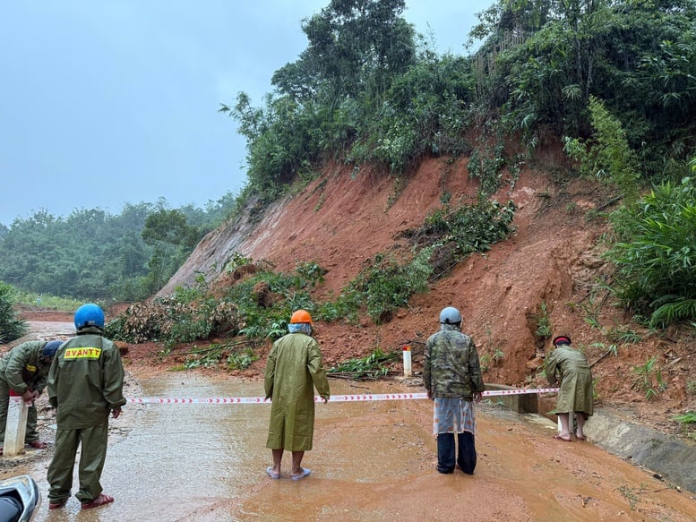
Numerous landslides have occurred in the mountainous areas of Da Nang city due to heavy rain and flooding.
Intensify evacuation efforts to ensure people's safety.
Given the complex developments of the floods and landslides, on October 27, the People's Committee of Da Nang City issued document No. 3261/UBND-PTDS regarding focusing on responding to and mitigating the consequences of floods and landslides.
Accordingly, the Chairman of the People's Committee of the City requested that the armed forces units, departments, agencies, People's Committees of communes, wards, special zones, and related units organize duty shifts, closely monitor weather forecasts and warnings about natural disasters, the situation of rain and floods, and promptly inform the people about the natural disaster situation so that they can proactively respond; implement disaster prevention and control plans; and continue to implement and ensure the contents as directed by the Chairman of the People's Committee of the City in the previous dispatch.
Chairpersons of the People's Committees of communes, wards, and special zones shall continue to maintain and implement activities to respond to heavy rain, floods, flash floods, and landslides. They shall proactively inspect and review areas that are not safe, especially areas that are deeply flooded, isolated, low-lying areas along rivers and streams, and areas at risk of flash floods and landslides. They shall proactively deploy forces to guard and set up checkpoints, strictly prohibiting people and vehicles from traveling on roads that are deeply flooded, have strong currents, are submerged, overflowing, on rivers, streams, reservoirs, and areas at high risk of landslides and flash floods.
Continue to maintain and strengthen evacuation activities to ensure people's safety, especially in dangerous areas, and ensure food supplies for people in flood- and landslide-affected areas and at evacuation sites, preventing people from going hungry or suffering from cold weather.
The Phong
Source: https://baochinhphu.vn/lu-dac-biet-lon-tren-song-vu-gia-thu-bon-co-the-vuot-dinh-lu-nam-2007-102251027171004031.htm






































Comment (0)