
Latest floods on the Red River and rivers in the North
According to the National Center for Hydro-Meteorological Forecasting, the flood situation on rivers in the past hours shows that the flood on Cau River (Bac Ninh Province) is receding slowly. The flood on Thai Binh River (Hai Duong City) is receding slowly. The flood on Hoang Long River (Ninh Binh Province) at Ben De is receding slowly.
Floodwaters on the Thuong River ( Bac Giang province) are receding slowly. Floodwaters on the Red River (Hanoi city) are receding rapidly. Floodwaters on the Luc Nam River (Bac Giang province) are receding slowly.
Water levels at 7:00 AM on September 13th on the following rivers were:
On the Cau River at Dap Cau, the water level is 7.66m, 1.36m above alarm level 3; and 0.18m below the historical flood level of 1971 (7.84m). On the Thuong River at Phu Lang Thuong, the water level is 6.95m, 0.65m above alarm level 3.
On the Luc Nam River at Luc Nam, the water level is 6.23m, 0.07m below alarm level 3. On the Hoang Long River at Ben De, the water level is 4.82m, 0.82m above alarm level 3; on the Thai Binh River at Pha Lai, the water level is 6.04m, 0.04m above alarm level 3; on the Red River at Hanoi , the water level is 10.02m, 0.48m below alarm level 2.
The National Center for Meteorological and Hydrological Forecasting predicts that over the next 24 hours, water levels at many downstream stations of the Red River-Thai Binh river system will tend to change slowly, generally remaining at high levels from alert level 2 to alert level 3, with some areas exceeding alert level 3, and receding slowly.
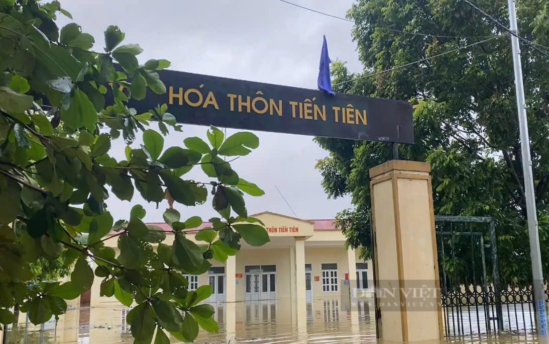
After just one night, all the villages in Chuong My (Hanoi) were submerged in water, it is forecasted that it will take 10-13 days for the water to completely recede in low-lying areas. Photo: Pham Thu
Specifically, in the next 12 hours, flood levels on the Luc Nam River will drop below alarm level 3; on the Cau River at Dap Cau, the Thuong River at Phu Lang Thuong, the Luc Nam River at Luc Nam, and the Hoang Long River at Ben De, flood levels will continue to drop but will still remain above alarm level 3; flood levels on the Red River in Hanoi will drop to alarm level 1.
Over the next 12-24 hours, flood levels on the Cau, Thuong, and Hoang Long rivers will continue to recede but will remain above alarm level 3; flood levels on the Luc Nam and Thai Binh rivers will continue to recede but will remain above alarm level 2; and flood levels on the Red River in Hanoi will fall below alarm level 1.
Flood warning for flooded areas
Although river levels have receded, as warned by the National Center for Meteorological and Hydrological Forecasting, the flood drainage and reduction process on the Red River system is likely to be slow. Therefore, flooding will continue for many days in low-lying areas along the riverbanks and alluvial plains outside the main dikes in the provinces/cities of Hanoi, Bac Giang, Bac Ninh, Thai Nguyen, Ninh Binh, Nam Dinh, Thai Binh, Ha Nam, and Hai Duong.
With the forecasted decrease in rain in the coming days, flooding in low-lying areas along the river will gradually improve.
"Water levels outside the dikes along the Red River in Hanoi will recede in the next 2-3 days, while in low-lying areas of Chuong My along the Bui River it will take 10-13 days, the Tich River about 7-10 days, the lower reaches of the Ca Lo River 3-5 days, and the Nhue River 2-3 days," the National Center for Meteorological and Hydrological Forecasting noted.
In the downstream areas of the Red River-Thai Binh River (Bac Giang, Bac Ninh, Ha Nam, Ninh Binh, Nam Dinh, Hung Yen, Thai Binh, and Hai Duong provinces), the water receding period lasts longer, from 3 to 6 days.
Flood water levels in the lower reaches of the Red River are currently at high levels (level 3 - above level 3), so there is still a risk of affecting riverside dykes and landslides at key locations in the following provinces/cities: Hanoi, Ha Nam, Nam Dinh, Hai Duong, Hung Yen, Thai Binh, Ninh Binh.
The risk of landslides remains on slopes in the mountainous areas of Northern Vietnam, even though the rain has subsided.
Source: https://danviet.vn/lu-tren-hang-loat-song-da-xuong-vung-trung-thap-chuong-my-cua-ha-noi-van-phai-mat-10-13-ngay-de-nuoc-rut-20240913100122427.htm
![[Photo] Prime Minister Pham Minh Chinh holds a phone call with the CEO of Russia's Rosatom Corporation.](/_next/image?url=https%3A%2F%2Fvphoto.vietnam.vn%2Fthumb%2F1200x675%2Fvietnam%2Fresource%2FIMAGE%2F2025%2F12%2F11%2F1765464552365_dsc-5295-jpg.webp&w=3840&q=75)


![[Photo] Closing Ceremony of the 10th Session of the 15th National Assembly](/_next/image?url=https%3A%2F%2Fvphoto.vietnam.vn%2Fthumb%2F1200x675%2Fvietnam%2Fresource%2FIMAGE%2F2025%2F12%2F11%2F1765448959967_image-1437-jpg.webp&w=3840&q=75)


![[OFFICIAL] MISA GROUP ANNOUNCES ITS PIONEERING BRAND POSITIONING IN BUILDING AGENTIC AI FOR BUSINESSES, HOUSEHOLDS, AND THE GOVERNMENT](https://vphoto.vietnam.vn/thumb/402x226/vietnam/resource/IMAGE/2025/12/11/1765444754256_agentic-ai_postfb-scaled.png)


Comment (0)