
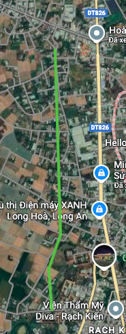
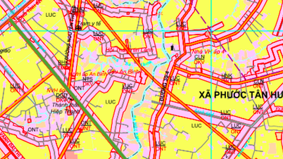
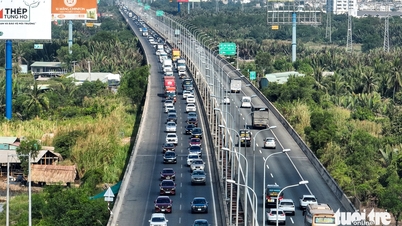
Overview of traffic planning of Rach Kien commune
According to the Land Use Planning Adjustment Map for the period 2021 - 2030 of Can Duoc district, Long An province, Rach Kien commune is oriented to open a number of new routes to strengthen connectivity and promote socio-economic development. Of which, there are two notable routes to help connect the key traffic axes of the area.

Details of two new routes according to planning
Based on the planning map, two main routes will be deployed in the future in Rach Kien commune, including one route cutting through Provincial Road 835 and one route running parallel to Provincial Road 826.
1. The route crosses Provincial Road 835
This route is expected to be approximately 2.3 km long. The starting point of the route intersects with Provincial Road 835, then heads west and north across the Doi Ma River. This route is expected to create a new connecting axis, reduce the load on existing routes and facilitate travel and freight transport.


2. Parallel route to Provincial Road 826
The second route is about 1.9 km long, planned to run almost parallel to Provincial Road 826. The construction of this route will contribute to forming a more synchronous traffic network, supporting Provincial Road 826 and opening up new development directions for areas along the route.

Note on planning information
The information on the above route is referenced from the Land Use Planning Adjustment Map for the period 2021 - 2030 of Can Duoc district, Long An province. The planning may be adjusted in the future depending on the actual development situation of the locality. People and investors should contact the authorities for the most accurate information at the time of interest.
Source: https://baolamdong.vn/quy-hoach-can-duoc-mo-hai-tuyen-duong-moi-tai-xa-rach-kien-407184.html


![[Photo] Cat Ba - Green island paradise](/_next/image?url=https%3A%2F%2Fvphoto.vietnam.vn%2Fthumb%2F1200x675%2Fvietnam%2Fresource%2FIMAGE%2F2025%2F12%2F04%2F1764821844074_ndo_br_1-dcbthienduongxanh638-jpg.webp&w=3840&q=75)


![[VIMC 40 days of lightning speed] Da Nang Port: Unity - Lightning speed - Breakthrough to the finish line](https://vphoto.vietnam.vn/thumb/402x226/vietnam/resource/IMAGE/2025/12/04/1764833540882_cdn_4-12-25.jpeg)


Comment (0)