
1. Current status of the super typhoon
At 04:00 on September 24th, the center of the super typhoon was located at approximately 21.3 degrees North latitude and 114.3 degrees East longitude, in the northern part of the South China Sea, about 650km east of Mong Cai ( Quang Ninh ). The strongest winds near the center of the super typhoon reached levels 15-16 (167-201 km/h), with gusts exceeding level 17. It was moving in a west-northwest direction at a speed of approximately 20 km/h.
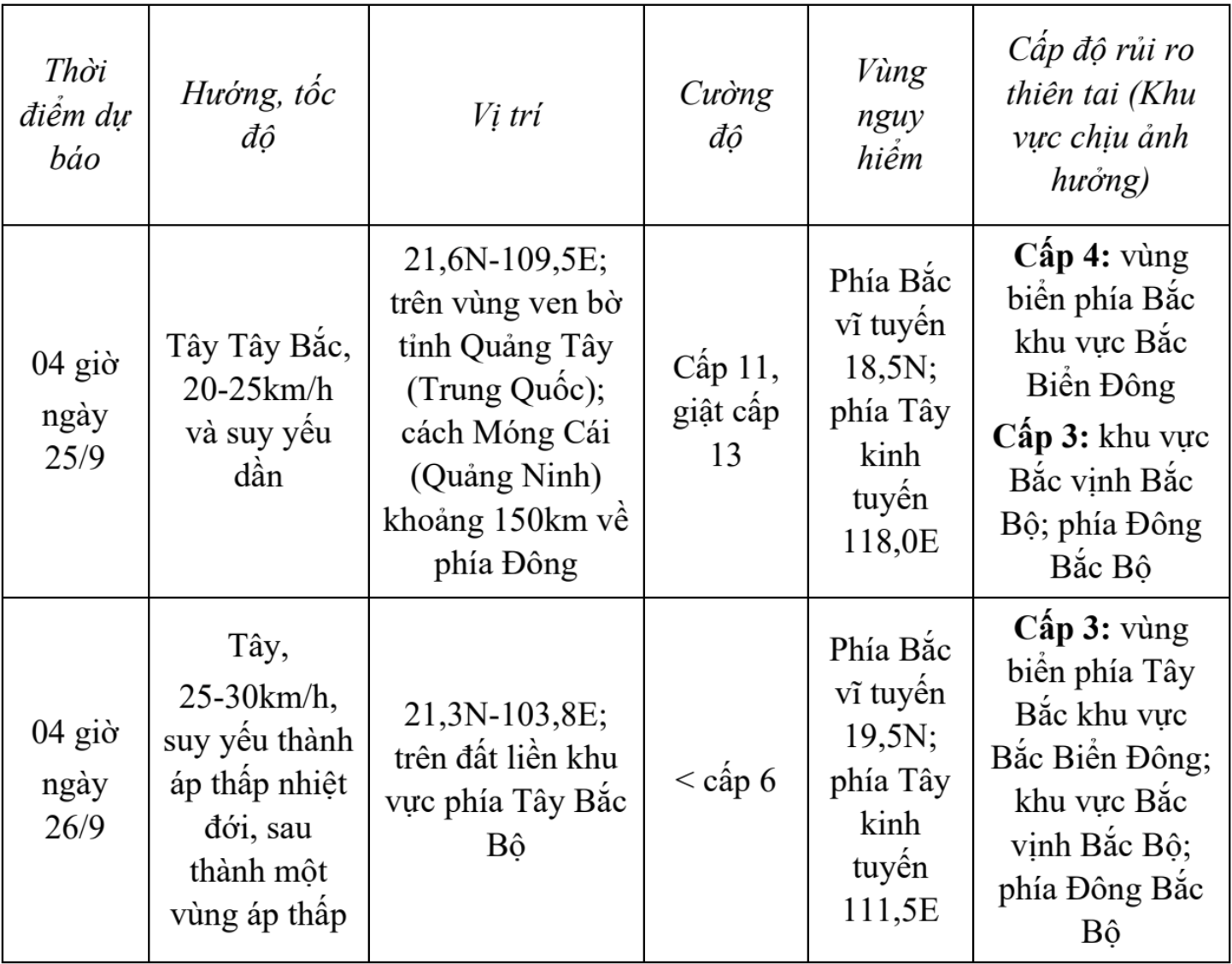
2. Forecast of the super typhoon's development (over the next 24 to 48 hours)
3. Forecast of the storm's impact
- Strong winds, high waves, rising water levels
At sea:
In the northern part of the South China Sea, winds are strong, reaching levels 10-13, with winds near the center of the super typhoon reaching levels 14-16, gusting above level 17, and waves exceeding 10.0m; the sea is extremely rough.
From September 24th, the eastern sea area of the northern Gulf of Tonkin (including the Bach Long Vy special zone) will experience increasingly strong winds, reaching levels 6-7, with gusts up to level 9.
From the night of September 24th, the sea area off Nghe An province (including Hon Ngu island) will experience increasingly strong winds, reaching levels 6-7, with gusts up to levels 8-9; sea waves will be 1.5-3.0m high, and the sea will be rough.
Heavy rain:
From September 25th to September 27th, Nghe An experienced moderate to heavy rain, with some areas experiencing very heavy rain and thunderstorms. The rainfall amount was generally 70-150mm, with some localized areas receiving over 250mm.
Be prepared for heavy rainfall causing urban flooding. Heavy rain is likely to cause flooding in low-lying areas; flash floods on small rivers and streams; and landslides on slopes.
Thunderstorms, tornadoes
Due to the influence of the wide storm circulation, there is a risk of thunderstorms, tornadoes, and strong gusts of wind both before and during the storm's landfall.
WEATHER FORECAST FOR SEPTEMBER 24TH (LAND AREA)
* Mountainous region
Cloudy to mostly cloudy, sunny during the day, scattered showers and thunderstorms in the afternoon and evening. Light wind.
- Temperature: 24 – 34 ° C
- Humidity: 80 - 90%
* Midlands region
Cloudy to mostly cloudy, sunny during the day with scattered showers and thunderstorms in the afternoon and evening. Light wind.
- Temperature: 26 – 34 ° C
- Humidity: 80 - 90%
* Coastal Plains region
Cloudy to mostly cloudy, sunny during the day. Scattered showers and thunderstorms in the afternoon and evening. West to southwest winds, force 2-3.
- Temperature: 26 – 33 ° C
- Humidity: 80 - 90%
* Cua Lo and Ngu Island area
Cloudy to mostly cloudy, sunny during the day. Showers and thunderstorms possible in the evening and at night. West to southwest winds, force 3-4.
- Temperature: 26 – 31 ° C
- Humidity: 85 - 90%
* Next 48 hours : Affected by the circulation of Typhoon Ragasa, Nghe An province will experience cloudy skies with moderate to heavy rain, very heavy rain in some areas, and scattered thunderstorms. Coastal areas will experience increasingly strong winds, reaching levels 4-5.
(Source: Weather forecast bulletin from Nghe An Meteorological Station)
Source: https://baonghean.vn/sieu-bao-ragasa-se-gay-mua-vua-den-mua-to-co-noi-mua-rat-to-o-nghe-an-10306993.html
![[Photo] Prime Minister Pham Minh Chinh holds a phone call with the CEO of Russia's Rosatom Corporation.](/_next/image?url=https%3A%2F%2Fvphoto.vietnam.vn%2Fthumb%2F1200x675%2Fvietnam%2Fresource%2FIMAGE%2F2025%2F12%2F11%2F1765464552365_dsc-5295-jpg.webp&w=3840&q=75)


Comment (0)