
Northeast wind gradually increases to level 2-3, coastal areas level 3-4. In the North and North Central regions, there will be scattered rain and light rain. From tonight, the weather will turn cold, with severe cold in some mountainous areas.
At the same time, scattered showers and thunderstorms were recorded in Hue City, the South Central Coast, the Central Highlands and Ho Chi Minh City, with some areas experiencing heavy to very heavy rain. Rainfall continued to be complicated when the moist cloud band combined with cold air caused widespread heavy rain in the Central region.
It is forecasted that on December 3, the area from South Quang Tri to Da Nang , East Quang Ngai to Dak Lak and Khanh Hoa will have moderate to heavy rain, with rainfall ranging from 40-100mm, with some places exceeding 150mm. Heavy rain will recur during the day and night of December 4 in the provinces from South Quang Tri to Da Nang City and East Quang Ngai with rainfall ranging from 40-80mm, with some places exceeding 150mm.
The Central Highlands and the South continue to have scattered showers and thunderstorms, with rainfall of 10-30mm, with heavy rain over 60mm in some places.
The meteorological agency warned that heavy rain in the area from South Quang Tri to Da Nang and East Quang Ngai will tend to decrease from December 5, but there is a high risk of flash floods, landslides in mountainous areas and localized flooding in urban areas.
At sea, at 1:00 a.m. on December 3, the center of the tropical depression was located at 13.6 degrees North latitude, 111.4 degrees East longitude, in the northwest sea area in the middle of the East Sea, with strong winds of level 6, gusts of level 8, and moving slowly in the southwest direction. This morning, the northwest sea area in the middle of the East Sea and off the coast of Gia Lai - Dak Lak had strong winds of level 6, gusts of level 8, rough seas with waves 2-4m high.
During the day and night of December 3, the North East Sea (including the Hoang Sa sea area) will have strong northeast winds of level 6-7, gusting to level 8-9, rough seas, and waves 3-5m high. In the Gulf of Tonkin, the wind will gradually increase to level 6 during the day, sometimes level 7, gusting to level 8, and gradually decrease at night, with waves 2-4m high.
On the afternoon and night of December 3, the sea area from South Quang Tri to Hue City and the North of the East Sea will have strong northeast winds of level 6, gusts of 7-8, rough seas. In addition, the sea area to the west of the East Sea and the sea area from South Quang Tri to Ca Mau will have scattered thunderstorms, risk of tornadoes, and strong gusts of level 6-7.
Localities need to closely monitor forecasts and proactively respond to heavy rain, strong winds at sea and severe cold in the northern mountainous regions.
Weather forecast for regions across the country:
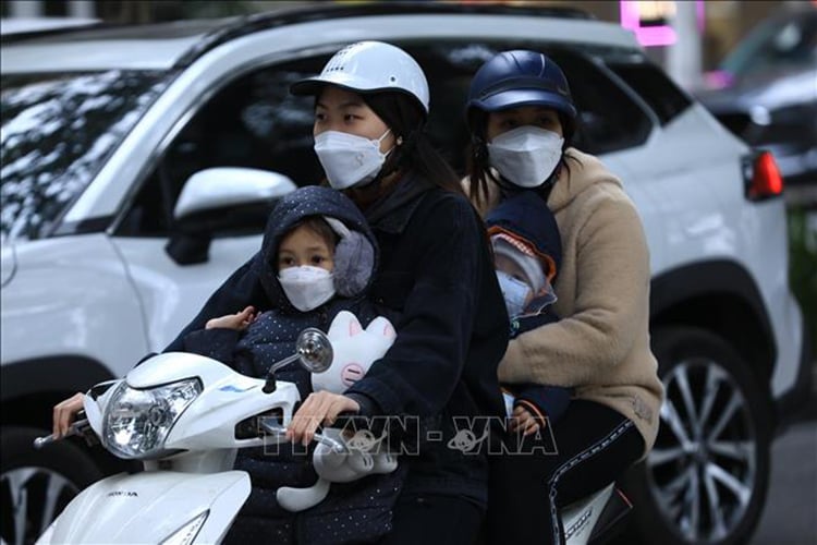
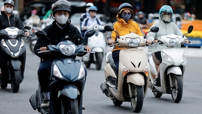
Hanoi capital is cloudy, with scattered rain and light rain during the day; no rain at night. Northeast wind level 2-3. Cold morning and night. Lowest temperature 15-18 degrees Celsius. Highest temperature 22-24 degrees Celsius.
The Northwestern provinces are cloudy with scattered showers and light rain; the Northwestern region is cloudy with some rain. Light wind. Mornings and nights are cold, with some places being very cold. The lowest temperature is 14-17 degrees Celsius, with some places below 13 degrees Celsius. The highest temperature is 22-25 degrees Celsius, with the Northwestern region being 25-27 degrees Celsius.
The Northeastern region is cloudy with scattered light rain during the day; some rain at night. Northeast wind level 2-3, coastal areas level 3-4. Cold in the morning and at night, some places in the mountains are very cold. Lowest temperature 15-18 degrees Celsius, mountainous areas 13-15 degrees Celsius, some places below 12 degrees Celsius. Highest temperature 21-24 degrees Celsius.
Provinces from Thanh Hoa to Hue are cloudy, with scattered rain in the North; rain, showers and thunderstorms in some places in the South, with heavy rain in some places, especially in the South of Quang Tri - Hue City, with moderate rain, heavy rain, and very heavy rain in some places. North to northwest wind level 2-3. Cold in the North in the morning and at night, cold in the South. During thunderstorms, there is a possibility of tornadoes, lightning and strong gusts of wind. Lowest temperature in the North is 16-18 degrees Celsius, in the South is 19-21 degrees Celsius. Highest temperature is 22-25 degrees Celsius.
The South Central Coast region is cloudy with moderate to heavy rain, some places with very heavy rain and thunderstorms. Northeast wind level 2-3. During thunderstorms, there is a possibility of tornadoes, lightning, hail and strong gusts of wind. The lowest temperature is 21-24 degrees Celsius, in the South, some places above 24 degrees Celsius. The highest temperature is 25-27 degrees Celsius in the North, 28-30 degrees Celsius in the South.
Central Highlands: Cloudy with scattered showers and thunderstorms, locally heavy rain. Light wind. Thunderstorms may include tornadoes, lightning, hail and strong gusts. Lowest temperature 18-21 degrees Celsius. Highest temperature 25-28 degrees Celsius.
The South is cloudy with scattered showers and thunderstorms, with scattered showers and thunderstorms in the afternoon and evening, and some places experiencing heavy rain. Light winds. During thunderstorms, there is a possibility of tornadoes, lightning, and strong gusts of wind. Lowest temperature 23-26 degrees Celsius. Highest temperature 29-32 degrees Celsius, some places above 32 degrees Celsius.
Ho Chi Minh City is cloudy with scattered showers and thunderstorms, with scattered showers and thunderstorms in the afternoon and evening. Light winds. Thunderstorms may cause tornadoes, lightning, and strong gusts of wind. Lowest temperature 24-26 degrees Celsius. Highest temperature 30-32 degrees Celsius.
Source: https://baotintuc.vn/xa-hoi/thoi-weather-ngay-312-khong-khi-lanh-tang-cuong-bac-bo-ret-tu-dem-nay-20251203054524962.htm

![[Photo] Worshiping the Tuyet Son statue - a nearly 400-year-old treasure at Keo Pagoda](/_next/image?url=https%3A%2F%2Fvphoto.vietnam.vn%2Fthumb%2F1200x675%2Fvietnam%2Fresource%2FIMAGE%2F2025%2F12%2F02%2F1764679323086_ndo_br_tempimageomw0hi-4884-jpg.webp&w=3840&q=75)
![[Photo] Parade to celebrate the 50th anniversary of Laos' National Day](/_next/image?url=https%3A%2F%2Fvphoto.vietnam.vn%2Fthumb%2F1200x675%2Fvietnam%2Fresource%2FIMAGE%2F2025%2F12%2F02%2F1764691918289_ndo_br_0-jpg.webp&w=3840&q=75)


![[Video] Protecting World Heritage from Extreme Climate Change](https://vphoto.vietnam.vn/thumb/402x226/vietnam/resource/IMAGE/2025/12/03/1764721929017_dung00-57-35-42982still012-jpg.webp)


Comment (0)