
It is forecasted that by 1:00 a.m. on December 9, the center of the low pressure will be at about 11.2 degrees North latitude - 117.8 degrees East longitude, in the sea area east of the central East Sea. Wind intensity will remain at level 6, gusting to level 8, continuing to move along the West-Southwest axis at a speed of 15-20 km/hour.
By 1 a.m. on December 10, the low pressure is forecast to move deep into the southern part of the East Sea, with its center at about 9.8 degrees North latitude - 113.5 degrees East longitude, about 200 km from Song Tu Tay Island. The strongest wind is still at level 6, gusting to level 8. After that, the circulation will gradually weaken and there is a high possibility of it dissipating into a low pressure area.
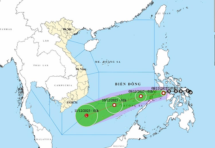
Meanwhile, the Northeast monsoon continues to be strong in the North East Sea. Records at Huyen Tran station show strong Northeast winds of level 6, sometimes level 7, gusting to level 8; at Phu Quy station, gusts of level 7 have appeared.
Forecast for the day and night of December 8, the North East Sea area, including the Hoang Sa sea area, will have strong northeast winds of level 6, sometimes level 7, gusting to level 8-9; rough seas, common high waves of 4-6m. The sea area to the southeast of the central East Sea area, including the sea area to the northeast of the Truong Sa sea area, will maintain winds of level 6, gusting to level 8; rough seas, high waves of 2-4m.
The remaining areas of the central East Sea and the sea area from Da Nang to Dak Lak have strong northeast winds of level 6, gusting to level 7-8; rough seas, waves 3-6m high. The sea area from Khanh Hoa to Ca Mau and the southwest of the East Sea, including the sea area west of Truong Sa, have strong northeast winds of level 6, sometimes level 7, gusting to level 8-9; rough seas, waves 3-5m high.
Particularly, the sea area from South Quang Tri to Hue has Northeast wind level 5, sometimes level 6, gusting to level 7-8; rough sea, waves 2-4m high.
In addition, during the day and night of December 8, the sea area in the southeast of the area between the East Sea and the South East Sea (including the Truong Sa sea area) will have scattered showers and thunderstorms. During thunderstorms, be on guard against tornadoes and strong gusts of wind of level 6-7.
Weather forecast for regions across the country:
Hanoi capital has rain in some places, early morning has fog and light fog scattered, afternoon less cloudy and sunny. Northeast wind level 2-3. Cold at night and morning. Lowest temperature 17-19 degrees Celsius. Highest temperature 23-26 degrees Celsius.
The Northwestern provinces have some rain, early morning there is scattered fog and light fog, afternoon and evening the clouds decrease and there is sunshine. Light wind. Night and morning is cold, some places are very cold. Lowest temperature 16-19 degrees Celsius, some places below 15 degrees Celsius. Highest temperature 22-25 degrees Celsius, Northwestern region 25-27 degrees Celsius.
In the Northeast region, there will be scattered rain, early morning fog and light fog, afternoon and evening the clouds will decrease and there will be sunshine. Northeast to east wind level 2-3. Cold at night and in the morning, some mountainous areas will be very cold. Lowest temperature 16-19 degrees Celsius, some mountainous areas below 15 degrees Celsius. Highest temperature 23-26 degrees Celsius.
Provinces from Thanh Hoa to Hue have scattered rain, early morning fog and light fog, in the North, the clouds decrease and there is sunshine in the afternoon. North to northwest wind level 2-3. In the North, it is cold at night, in the South, it is cold. Lowest temperature 17-20 degrees Celsius. Highest temperature 22-25 degrees Celsius.
In the South Central Coast region, there will be scattered showers and thunderstorms at night, and scattered showers and thunderstorms during the day. Northeast wind level 3-4. During thunderstorms, there is a possibility of tornadoes, lightning, and strong gusts of wind. Lowest temperature 20-23 degrees Celsius. Highest temperature 26-29 degrees Celsius.
Central Highlands showers and thunderstorms in some places. Northeast wind level 2-3. During thunderstorms, tornadoes, lightning and strong gusts of wind may occur. Lowest temperature 16-19 degrees Celsius. Highest temperature 25-28 degrees Celsius, some places above 28 degrees Celsius.
Southern region: Showers and thunderstorms in some places. Northeast wind level 2-3. During thunderstorms, there is a risk of tornadoes, lightning and strong gusts of wind. Lowest temperature 23-25 degrees Celsius, in the East 20-23 degrees Celsius. Highest temperature 29-32 degrees Celsius, in some places over 32 degrees Celsius.
Ho Chi Minh City has scattered showers and thunderstorms. Northeast wind level 2-3. During thunderstorms, beware of tornadoes, lightning, and strong gusts of wind. Lowest temperature 21-23 degrees Celsius. Highest temperature 30-32 degrees Celsius.
Source: https://baotintuc.vn/xa-hoi/thoi-tiet-ngay-812-ap-thap-tien-vao-bien-dong-gio-manh-gay-bien-dong-tren-dien-rong-20251208060043385.htm


Comment (0)