
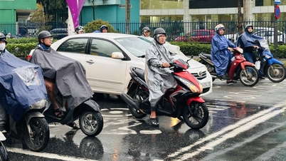
At this time, the coastal areas of the North and the east of the South are experiencing high tides, which can cause flooding and negatively impact maritime activities and sea tourism .
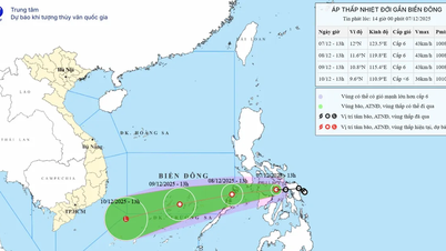
According to the National Center for Hydro-Meteorological Forecasting, at 7:00 a.m. on December 8, the tropical depression was in the eastern coastal area of the Philippines and was about to enter the East Sea. The wind intensity near the center of the tropical depression was strong at level 6 (39-49 km/h), gusting to level 8.
It is forecasted that in the next 24 hours, the tropical depression will continue to move west-southwest at a speed of 15-20 km/h, weakening into a low pressure area with wind intensity below level 6 in the central East Sea. According to this development, the sea area southeast of the central East Sea (including the sea area northeast of Truong Sa special zone) will have winds gradually increasing to level 6, gusting to level 8, waves 2-4 m high, rough seas.

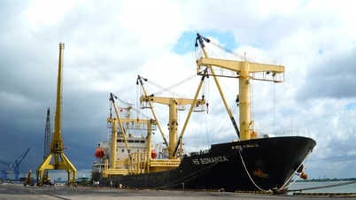
The tropical depression is forecast to dissipate into a low pressure area after entering the East Sea. Photo: NCHMF .
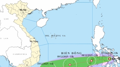
In addition, the strong northeast monsoon has made the weather in the northern East Sea (including Hoang Sa special zone) unfavorable. On the day and night of December 8, the northeast wind is strong at level 6-7, gusting at level 8-9; the sea is rough, with waves 4-6 m high.
The remaining areas of the central East Sea and the sea from Da Nang to Dak Lak have strong northeast winds of level 6, gusting to level 7-8; rough seas, waves 3-6 m high.
The sea area from Khanh Hoa to Ca Mau and the west of the southern East Sea (including the sea area west of Truong Sa special zone) has strong northeast wind level 6, sometimes level 7, gusting to level 8-9; rough sea, waves 3-5 m high.
Particularly, the sea area from southern Quang Tri to Hue city has northeast wind level 5, sometimes level 6, gusting to level 7-8; rough sea, waves 2-4 m high.

The highest wave height is forecast for December 8, with waves ranging from 2-6 m high in coastal areas of the central provinces. Photo: NCHMF .
In addition, during the day and night of December 8, the sea area southeast of the Central East Sea and the South East Sea (including Truong Sa special zone) will have scattered showers and thunderstorms; during thunderstorms, there is a possibility of tornadoes and strong gusts of wind of level 6-7.
Vessels operating in the above sea areas are susceptible to storms, whirlwinds, strong winds and large waves.
On the other hand, at this time, the water level in the Northern and Southeastern coastal areas is in the high tide period. In the Northern region, the highest daily peak tide at Hon Dau station is likely to reach 4.15-4.25 m. Low-lying areas along the coast, along rivers, and areas outside the dike are likely to be flooded between 4am and 7am every day.
The coast from Ho Chi Minh City to Ca Mau is experiencing high tide. Forecast: From 2pm - 5pm and 11pm - 2am the next morning is the highest tide period, about 4.2-4.3m.
The coastal areas of the North and the East of the South need to be on guard against strong offshore currents during low tide, especially in the morning (low water) and afternoon (high water), which are dangerous for maritime activities and sea tourism, especially at ports and beaches. The coastal areas from South Quang Tri to Khanh Hoa need to be aware of strong currents of over 1m/s.
High water levels and strong currents pose a high risk of flooding and dike overtopping in low-lying coastal and riverside areas, and outside the dikes. These impacts can affect transportation, agricultural production, aquaculture, water pollution, and people's daily lives.
Source: https://nongnghiepmoitruong.vn/ap-thap-nhiet-doi-suy-yeu-nhanh-tren-bien-d788155.html
![[Photo] General Secretary To Lam receives the Director of the Academy of Public Administration and National Economy under the President of the Russian Federation](/_next/image?url=https%3A%2F%2Fvphoto.vietnam.vn%2Fthumb%2F1200x675%2Fvietnam%2Fresource%2FIMAGE%2F2025%2F12%2F08%2F1765200203892_a1-bnd-0933-4198-jpg.webp&w=3840&q=75)


Comment (0)