
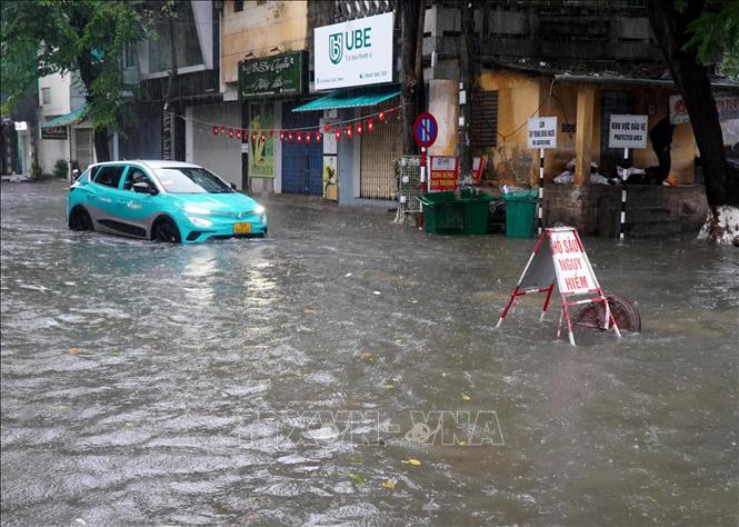
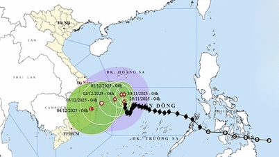
From the night of December 3 to December 5, the area from Quang Tri to Da Nang city and the east of Quang Ngai province will have moderate rain, heavy rain, and locally very heavy rain with common rainfall of 50-150mm, locally over 250mm.
Warning of risk of heavy rain over 100mm/3h. Level 1 risk of natural disasters due to heavy rain, tornadoes, lightning, and hail.
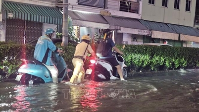
Heavy rains are likely to cause flooding in low-lying areas, urban and industrial areas; flash floods on small rivers and streams, landslides on steep slopes (real-time warning information on areas at risk of flash floods and landslides is provided online on the website of the Department of Hydrometeorology at: https://luquetsatlo.nchmf.gov.vn and in separate bulletins warning of flash floods and landslides).
Flash floods and landslides can have very negative impacts on the environment, threaten people's lives; cause local traffic congestion, affect the movement of vehicles; destroy civil and economic works, causing damage to production and socio-economic activities.
The hydrometeorological agency noted that people need to regularly monitor forecast and warning information on the website of the National Center for Hydrometeorological Forecasting at nchmf.gov.vn, the provincial, municipal and regional hydrometeorological stations, and regularly update the latest hydrometeorological forecast information on the official mass media of the Central and local levels to proactively respond, and at the same time recommend that the authorities in the affected localities pay attention to reviewing the flow bottlenecks and vulnerable locations in the area to have preventive and response measures.
According to the guidance of the Department of Dyke Management and Natural Disaster Prevention and Control (Ministry of Agriculture and Environment), in the face of the above situation, affected areas should closely monitor developments of heavy rain, floods, flash floods, landslides, and promptly and fully inform authorities and people at all levels to proactively prevent, respond, and minimize damage.
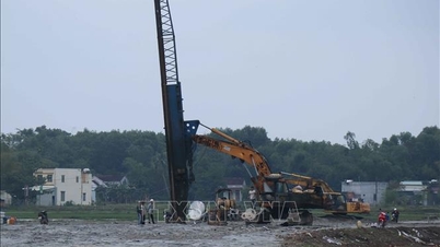
Localities deploy shock forces to inspect and review residential areas along rivers, streams, and low-lying areas to proactively organize the relocation and evacuation of people in areas at high risk of deep flooding, flash floods, and landslides; organize forces ready to control and guide traffic, and put up warning signs, especially through culverts, spillways, and areas with deep flooding and fast-flowing water; proactively arrange forces, materials, and means to overcome incidents and ensure smooth traffic on main traffic routes when heavy rain occurs.
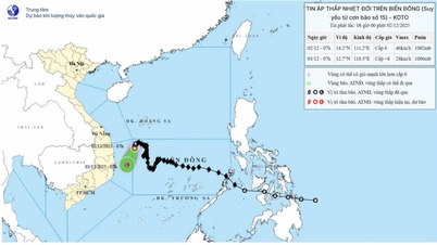
At sea, Ly Son station has recorded strong northeast winds of level 5, sometimes level 6, gusting to level 7.
Forecast for the day and night of December 1, the northwest area of the central East Sea will have strong winds of level 6; the area near the storm's eye will have winds of level 7-8, gusting to level 10, rough seas, waves about 2-4m high, the area near the storm's eye will be 3-5m high, wave direction will change according to the storm's circulation.
The Southwestern sea area of the North East Sea has strong Northeast to East winds at level 6, gusting to level 7-8, rough seas; waves 2-4m high.
The sea area from Quang Ngai to Khanh Hoa has strong North wind level 6, gusting to level 7-8, rough sea; waves 2-4m high.
In addition, during the day and night of December 1, the western sea area in the middle of the East Sea, the southwestern sea area in the North of the East Sea (including Hoang Sa special zone), and the sea area from Gia Lai to Khanh Hoa will have scattered showers and thunderstorms; in particular, the northwest of the middle of the East Sea will have storms, with the possibility of tornadoes and strong gusts of wind.
Warning: During the day and night of December 2, the northwest sea area between the East Sea and the sea area from Gia Lai to Khanh Hoa will have strong winds of level 6, gusts of level 7-8, rough seas with waves 2-4m high; in the northwest of the East Sea, the wind will gradually decrease at night.
The risk of natural disasters at sea is level 2; the northwest sea area of the central East Sea is level 3.
Vessels operating in the above areas are at high risk of being affected by strong winds and large waves.
Coastal areas from Da Nang to Khanh Hoa need to be on guard against high tides combined with large waves, which can cause dike overflow, coastal flooding and coastal erosion.
Source: https://baotintuc.vn/xa-hoi/tu-dem-212-den-ngay-512-trung-bo-co-noi-mua-rat-to-20251201102451264.htm

![[Photo] Worshiping the Tuyet Son statue - a nearly 400-year-old treasure at Keo Pagoda](/_next/image?url=https%3A%2F%2Fvphoto.vietnam.vn%2Fthumb%2F1200x675%2Fvietnam%2Fresource%2FIMAGE%2F2025%2F12%2F02%2F1764679323086_ndo_br_tempimageomw0hi-4884-jpg.webp&w=3840&q=75)
![[Photo] Parade to celebrate the 50th anniversary of Laos' National Day](/_next/image?url=https%3A%2F%2Fvphoto.vietnam.vn%2Fthumb%2F1200x675%2Fvietnam%2Fresource%2FIMAGE%2F2025%2F12%2F02%2F1764691918289_ndo_br_0-jpg.webp&w=3840&q=75)


![[Video] Protecting World Heritage from Extreme Climate Change](https://vphoto.vietnam.vn/thumb/402x226/vietnam/resource/IMAGE/2025/12/03/1764721929017_dung00-57-35-42982still012-jpg.webp)


Comment (0)