

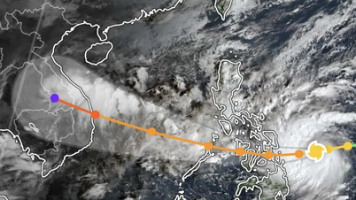
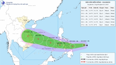
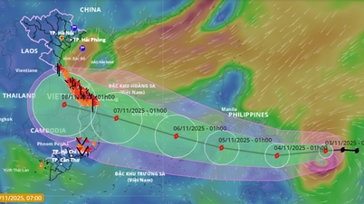
At 4 p.m., the center of the storm was at about 11.2 degrees North latitude; 132.5 degrees East longitude, in the sea east of the central Philippines with the strongest wind near the center of the storm at level 9 (75-88 km/h), gusting to level 11. Moving west at a fast speed of about 25 km/h.
At 4:00 p.m. on November 3, the storm was in the sea east of the central Philippines with strong winds of level 11-12, gusting to level 15-16, moving mainly west at a speed of about 20km/h and likely to strengthen.
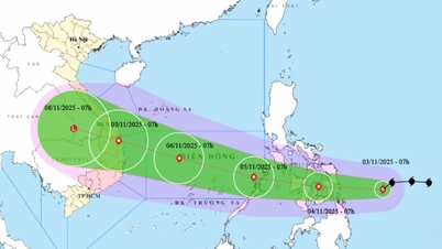
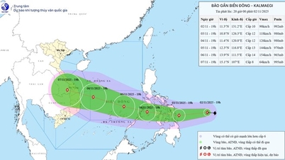
As of 4 p.m. on November 4, the storm in the western central Philippines with strong winds of level 12, gusts of level 15, was moving mainly in the West Northwest direction at a speed of about 20-25 km/h and was likely to intensify. The affected area was the sea area east of the central part of the East Sea. Disaster risk level 3.
As of 4 p.m. on November 5, the storm was in the central East Sea with strong winds of level 13, gusts of level 16-17, moving west-northwest at a speed of about 15 km/h and likely to intensify. The affected area is the central East Sea (including Truong Sa special zone). Disaster risk level 3.
From the next 72 to 120 hours, the storm will move mainly in the West Northwest direction, about 25km per hour and will likely strengthen.
Due to the impact of the storm, from the afternoon and night of November 4, the eastern sea area in the central East Sea will have winds gradually increasing to level 6-7, then increasing to level 8-9; the area near the storm's center will have strong winds of level 10-12, gusting to level 14-15, waves 5-7m high, and rough seas.
Warning: During November 5-6, the central area of the East Sea (including Truong Sa special zone), the sea off the coast of Da Nang - Khanh Hoa area is likely to be
affected by strong winds of level 12-14, gusts above level 17, waves 8-10m high, rough seas
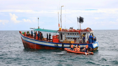
All boats operating in the above mentioned danger zones are susceptible to storms, whirlwinds, strong winds and large waves.
Source: https://baotintuc.vn/van-de-quan-tam/bao-gan-bien-dong-voi-ten-quoc-te-kalmaegi-20251102190137066.htm
![[Photo] President Luong Cuong receives US Secretary of War Pete Hegseth](https://vphoto.vietnam.vn/thumb/1200x675/vietnam/resource/IMAGE/2025/11/02/1762089839868_ndo_br_1-jpg.webp)
![[Photo] Lam Dong: Images of damage after a suspected lake burst in Tuy Phong](https://vphoto.vietnam.vn/thumb/1200x675/vietnam/resource/IMAGE/2025/11/02/1762078736805_8e7f5424f473782d2162-5118-jpg.webp)


Comment (0)