
On the evening of November 4, in Hanoi , the Department of Meteorology and Hydrology held a meeting to provide information on the situation of storm Kalmaegi. Director of the National Center for Hydro-Meteorological Forecasting Mai Van Khiem chaired the meeting.

At the meeting, a representative of the National Center for Hydro-Meteorological Forecasting said that on the evening of November 1, the tropical depression in the sea east of the central Philippines had strengthened into storm Kalmaegi.
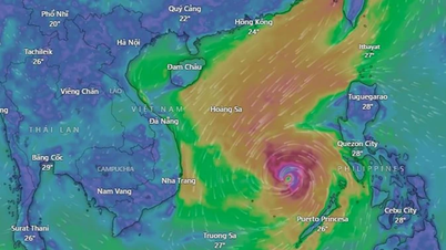
From the night of November 4 to the early morning of November 5, storm Kalmaegi crossed the north of Palawan Island (Philippines) into the East Sea, becoming storm number 13, possibly reaching an intensity of over level 14 in the Truong Sa special zone and the sea area of Da Nang - Khanh Hoa.

Mr. Mai Van Khiem said that since the evening of November 2, the National Center for Hydro-Meteorological Forecasting has issued a storm warning near the East Sea, predicting that the storm will enter the East Sea early in the morning of November 5. The storm will move towards the Vietnamese mainland, focusing on the area from Da Nang City to Dak Lak Province.
At the meeting, representatives of the National Center for Hydro-Meteorological Forecasting said that around the afternoon of November 6, the storm will move into the central sea area and from the night of November 6, the storm is likely to directly affect the area from Da Nang to Khanh Hoa, causing strong winds (coastal areas may have strong storm winds of level 10-12, gusts of level 15, deep inland there may be strong storm winds of level 7-9, gusts of level 13-14) and heavy rain from the night of November 6 to 9, with heavy rain concentrated in the provinces from Quang Tri to Dak Lak.
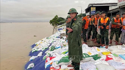
Mr. Mai Van Khiem warned: This is a very strong storm, with a wide storm circulation and strong winds that directly affect coastal provinces and cities from southern Quang Tri province to Dak Lak province (the path and impact are similar to storm No. 12 - Damrey in 2017 and storm No. 9 - Molave in 2020).
Source: https://www.sggp.org.vn/bao-kalmaegi-nguy-hiem-tuong-tu-bao-damrey-va-molave-post821703.html
![[Photo] Ca Mau "struggling" to cope with the highest tide of the year, forecast to exceed alert level 3](https://vphoto.vietnam.vn/thumb/1200x675/vietnam/resource/IMAGE/2025/11/04/1762235371445_ndo_br_trieu-cuong-2-6486-jpg.webp)

![[Photo] Ho Chi Minh City Youth Take Action for a Cleaner Environment](https://vphoto.vietnam.vn/thumb/1200x675/vietnam/resource/IMAGE/2025/11/04/1762233574890_550816358-1108586934787014-6430522970717297480-n-1-jpg.webp)
![[Photo] Panorama of the Patriotic Emulation Congress of Nhan Dan Newspaper for the period 2025-2030](https://vphoto.vietnam.vn/thumb/1200x675/vietnam/resource/IMAGE/2025/11/04/1762252775462_ndo_br_dhthiduayeuncbaond-6125-jpg.webp)

![[Photo] The road connecting Dong Nai with Ho Chi Minh City is still unfinished after 5 years of construction.](https://vphoto.vietnam.vn/thumb/1200x675/vietnam/resource/IMAGE/2025/11/04/1762241675985_ndo_br_dji-20251104104418-0635-d-resize-1295-jpg.webp)


Comment (0)